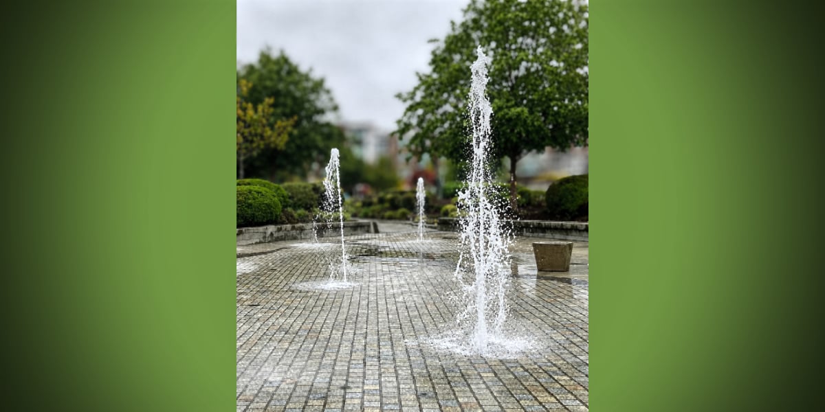
We’re pretty sure that the last time a tsunami hit the northwest coast of the U.S. was in 1964, shortly after a major earthquake struck Alaska; far as we know, it damaged some places on the Oregon coast, including Cannon Beach.

Saturday morning (Feb. 27th), imagine our surprise when we saw an “Advisory” posted in our Weather Widget in the right sidebar. Clicking on it revealed that yes, a “Tsunami Advisory” had been issued for the northern and central Washington coast after a huge, 8.8 quake hit Chile´.

We don’t think this is cause for panic in the Puget Sound region, but we wanted to share this info because, well, who knows – maybe a tsunami-based wave will hit the shorelines near Burien? Maybe not?

The advisory warns that, if indeed a tsunami wave makes it up the coast, takes a right turn through the Strait of Juan de Fuca, makes another right and heads down through the upper islands of Puget Sound…when (and if) it hits Pier 48 in Seattle it’s predicted to be .13 feet high, which, according to our rudimentary math skills, equals a measly 1.56 inches high.

According to this NOAA website, the predicted time for this wave to strike Seattle is 1641 PST – for us non-military types, that’s 4:41pm Saturday afternoon.

If you happen to have a video camera and a lot of free time this afternoon, why not hang out near one of Burien’s beaches around 4:30-5pm and see if you can videotape a 1.56 inch wave barreling in from the north? We’d love to post it – please email us if you do!

And if you know anyone who lives on the coast, or in Hawaii, please make sure they’re aware of this advisory, as it could be very serious in those areas.

According to the National Weather Service:

Persons in tsunami advisory areas should move out of the water… off the beach and out of harbors and marinas.

Tsunami advisories mean that a tsunami capable of producing strong currents or waves dangerous to persons in or very near water is imminent or expected. Significant widespread inundation is not expected for areas in an advisory. Tsunamis are a series of waves potentially dangerous several hours after initial arrival time. Estimated times of initial wave arrival for selected sites in the advisory are provided below.

Here’s the “Tsunami Advisory” language as posted at 9:18am:

Tsunami Advisory

Statement as of 9:18 AM PST on February 27, 2010

… A tsunami advisory remains in effect for the northern and central Washington coast…

A tsunami advisory remains in effect for the northern and central Washington coast.

There is no Tsunami Watch or warning in effect for the Washington coast. Repeat… there is no Tsunami Watch or warning in effect.

A powerful 8.8 magnitude earthquake occurred at 1034 PM PDT Friday near the central coast of chile. It has generated a tsunami wave… which is now spreading out across the Pacific Ocean.

The first tsunami waves are expected to reach the Washington coast between 250 PM and 310 PM PST this afternoon. The following are the
estimated arrival times of the first waves.

  • Seaside or… … ..246 PM PST
  • Westport WA… … .257 PM PST
  • Neah Bay WA… … .307 PM PST

The largest tsunami waves are expected two hours after the first arrival.

The waves are not expected to be large enough to cause coastal flooding along the Washington coast. However… some coastal areas could experience dangerous currents and surges in harbors and bays. Forecast tsunami wave amplitudes follow.

  • Long Beach WA… ..0.46 ft
  • Westport… … … .0.78 ft
  • Moclips… … … ..1.27 ft
  • Neah Bay… … … .0.65 ft
  • Port Angeles… … 0.33 ft
  • Bellingham… … ..0.46 ft
  • Everett… … … ..0.13 ft
  • Seattle-pier 48… 0.13 ft

The minimum wave height for a tsunami advisory on the Washington coast is 6 inches or 15 centimeters.

The initial wave will not be the largest. Coastal residents are advised to stay out of the water… off the beach… and away from harbors and marinas. Wave heights and currents are amplified by irregular shoreline and are difficult to predict. The tsunami may not be visible among the common ocean surf… yet tide gages will likely report some fluctuations.

Mariners in water deeper than 600 feet should not be affected by a tsunami.

Repeat… no Tsunami Watch or warning is in effect for the northern and central Washington coast.

And just ‘cuz we found it and we love science, here’s a pretty cool simulation video of what might happen if a tsunami hit Elliott Bay:

YouTube Preview Image

UPDATE: 1:45pm PST: So far, no tsunami yet in Hawaii, but this type of rare event is considered and “inexact science.” Here’s a link to a website that’s broadcasting a live TV signal from Hawaii.

Also, here’s the live webcam feed from Burien’s Seahurst Park Beach, just in case; refresh this page to see the latest:

The National Weather Service issued an unusual Advisory Monday (Jan. 18th) – this one for a “minor tidal overflow” that will be in effect for Puget Sound Tuesday morning and possibly again Wednesday morning.

According to the report, “very high astronomical tides combined with lower than normal atmospheric pressures” as well as high winds may cause some flooding.

So, if you live near the shoreline and your street/yard/area has a tendency to flood, you might want to put out some sandbags just in case.

Here’s the actual advisory:

… Coastal Flood Advisory for minor tidal overflow is in effect for Puget Sound and the north interior from 5 am to 11 am PST Tuesday…

The National Weather Service in Seattle has issued a coastal Flood Advisory for minor tidal overflow from Puget Sound to the north interior… which is in effect from 5 am to 11 am PST Tuesday.

Minor tidal overflow may occur along some of the shorelines and nearby low-lying areas around Puget Sound and the north interior Tuesday morning… around the time of high tide. Minor tidal overflow is caused by very high astronomical tides combined with lower than normal atmospheric pressures. The Table below shows time of high tide for areas around Puget Sound… along with the normal tide table value and the expected total tide.

Time of tide table expected expected location high tide value anomaly total tide

  • Seattle 7:30 am 12.2 ft 1.6 ft 13.8 ft
  • Port Townsend 7:06 am 9.1 ft 1.8 ft 10.9 ft
  • Bellingham 8:12 am 9.6 ft 1.9 ft 11.5 ft

Minor tidal overflow problems usually begin at 13.5 feet around Seattle and 11.5 feet around Bellingham… and the current forecasts for those areas just meet or exceed those levels. In addition… the atmospheric pressure could be a little lower than forecast… and local winds may cause water to pile up along shorelines more than expected… possibly higher than the expected total tide values. Southeast winds 20 to 30 knots are forecast over the northern inland waters Tuesday morning as another deep low pressure system moves northward offshore. Winds over the waters of Puget Sound are expected to be south 10 to 20 knots Tuesday morning.

Another very high astronomical tide will occur Wednesday morning. The forecast tides for Wednesday morning are slightly lower than for Tuesday… but computer model forecasts indicate the anomaly will still be large enough so that minor tidal overflow problems remain a possibility.

Precautionary/preparedness actions…

Minor tidal over flow can cause local flooding along shorelines and nearby low-lying areas.

The National Weather Service has released an updated forecast for this weekend, and they’re saying we may, just possibly have a 30-40% chance of SNOW starting Friday night (Dec. 11th) continuing through Sunday.

Of course, weather prognosticators are never wrong, are they? We sure hope not.

Here’s their latest day-by-day predictions, as of 9pm Wednesday Dec. 9th, most certain to change as the clock ticks:

  • Thursday Night: Mostly cloudy, with a low around 26. East northeast wind around 6 mph becoming calm.
  • Friday: Mostly cloudy, with a high near 38. Calm wind.
  • Friday Night: A 30 percent chance of snow. Cloudy, with a low around 28. Calm wind becoming north northeast around 6 mph.
  • Saturday: A 40 percent chance of snow. Snow level 300 feet. Cloudy, with a high near 40.
  • Saturday Night: A chance of snow. Snow level 300 feet. Cloudy, with a low around 32. Chance of precipitation is 50%.
  • Sunday: A chance of rain and snow showers. Cloudy, with a high near 41.
  • Sunday Night: A chance of rain and snow showers. Cloudy, with a low around 36.
  • Monday: A chance of rain and snow. Cloudy, with a high near 42.
  • Monday Night: A chance of rain. Cloudy, with a low around 42.

Cliff Mass adds:

A lot of you are wondering about snow. I have been wondering too. The problem is that the models are not consistent for this weekend and early next week. This morning our local model forced by the GFS..the NWS’s best large scale forecast model, indicated a major snowstorm late Monday. But I don’t trust any of it at this point and you shouldn’t either. Thursday and Friday until dinnertime looks dry for western Washington…and cold. You can bank on that.

BTW, a record low of 18 was set at SeaTac Airport Wednesday morning (Dec. 9th). The previous low was 21, set in 1972.

Two advisories were released Friday (Dec. 4th) – by the National Weather Service and King County, warning of “Arctic air” moving in as well as the possibility of “slick driving conditions” this weekend as temps drop down into the low 30s and upper 20s.

Sadly for most school-aged children, no snow is in the forecast (sorry kids…).

First, the National Weather Service’s “Special Weather Statement” released at 4:46pm 12/4:

… Cold weather to continue into next week for western Washington…

A secondary and stronger surge of cold air will filter into western Washington late this weekend. Temperatures will continue to run well below normal into late next week as Arctic high pressure slides south in western Canada allowing modified Arctic air into the area. High temperatures will remain in the 30s through most of next week with low temperatures well below freezing.

Snow showers are possible Saturday night as an upper low passes over the region. No accumulations are expected… except perhaps light accumulations for the northern shores of the Olympic peninsula where an upslope component and moisture picked up over the northern interior waters may produce accumulating snows late Saturday night and Sunday morning. Windy conditions will develop  Saturday evening through the first half of Sunday for the northern interior and Strait of Juan de Fuca as Fraser outflow increases.

And here’s King County’s warning on road conditions (link to the county’s road condition map here):

King County Road Alert Spotlight

The King County Road Services Division is alerting motorists of the possibility of slick driving conditions as temperatures cool and roads remain wet.

A brief rain shower that moved through parts of the county this afternoon may leave just enough moisture on some roadways to cause slick driving conditions tonight.

While many roads in unincorporated King County have been treated with anti-icing materials, motorists should still be on the lookout for icy stretches of roadway, especially in higher elevation areas and on bridges and overpasses.

If you are traveling tonight or early tomorrow morning, use extra caution and be prepared for winter driving.

And one more weather-related blurb to share, this one from noted Meteorologist Cliff Mass’ Blog on Thursday, Dec. 3rd

You have delicate plants…protect them. When the winds die down on Monday morning the temperatures could plummet on the western side into the teens in some locations. Maybe even colder Tuesday am. Good weather for plumbers–could have some frozen and bursting pipes.

And watch the action offshore! As the cold air moves over the relatively warm water there will developing cumulus activity…including showers. There will be lines of convection…should be impressive.

Monday and Tuesday will be cold and sunny. That’s far enough to forecast…but remember…sometimes the most interesting weather happens when a cold spell ends. I won’t even mention that unspeakable four letter word: S**W. Don’t even think about it.

The National Weather Service issued a “Wind Advisory” early Wednesday morning, so again, be sure to double-tie down your blue (and other colored) tarps Burien, as sustained winds of 20-30mph may be coming.

Here’s the advisory in all its weatherspeak glory:

… Wind Advisory in effect from 1 PM this afternoon to 1 am PST Thursday…

The National Weather Service in Seattle has issued a Wind Advisory… which is in effect from 1 PM this afternoon to 1 am PST Thursday.

Southerly winds will increase today… peaking late this afternoon through the evening hours. Sustained winds of 20 to 30 mph are expected with gusts to 40 to 50 mph… mainly this evening. The strongest winds are expected to occur over the north Hood Canal across to western Snohomish County… the entrances to the Strait and over the lower Chehalis valley.

Precautionary/preparedness actions…

A Wind Advisory is issued when sustained winds of 30 to 39 mph or gusts of 45 to 57 mph are likely. Winds this strong can snap small tree branches… topple small or shallow-rooted trees… and cause local power outages.

You know it’s November in the Northwest when another Weather Advisory gets posted – this one a “Wind Advisory” predicted to hit around 6pm Sunday night and continue for at least another 24 hours.

As usual, batten down your blue tarps Burien!

Here’s the statement, issued by the National Weather Service at 3:22pm Sunday, Nov. 15th:

Statement as of 3:22 PM PST on November 15, 2009

… Wind Advisory in effect from 6 PM this evening to 6 PM PST Monday…

… High wind watch in effect from Monday evening through Tuesday afternoon…

The National Weather Service in Seattle has issued a Wind Advisory… which is in effect from 6 PM this evening to 6 PM PST Monday. A high wind watch has also been issued. This high wind watch is in effect from Monday evening through Tuesday afternoon.

South winds of 25 to 35 mph with local gusts to 50 mph are expected to develop tonight and continue through much of the day Tuesday.

A deeper low is expected to move north through the coastal waters late Monday night and Tuesday. Widespread damaging winds of 40 mph with gusts to 60 mph are possible with this second deeper system.

Precautionary/preparedness actions…

A Wind Advisory is issued when sustained winds of 30 to 39 mph or gusts of 45 to 57 mph are likely. Winds this strong can snap small tree branches… topple small or shallow-rooted trees… and cause local power outages.

A high wind watch means conditions are favorable for damaging winds. High winds can topple trees… down power lines… and damage some structures. People in the watch area should prepare for the possibility of power outages.

The National Weather Service issued a “Special Weather Statement” at 4:30pm Thursday (Nov. 12th), warning of a “vigorous cold front” hitting the area Friday morning, bringing rain, wind and snow to the mountains.

Could this be the first breath of ol’ man winter?

Here’s the statement:

… Active weather day expected Friday…

A vigorous cold front will pass southeast across western Washington Friday morning… bringing Rain… Mountain snows… locally windy conditions and possibly snow showers to parts of The Lowlands.

South winds in advance of the front will increase late tonight into early Friday morning… mainly along the coast and parts of the northwest interior including the Admiralty Inlet region. Wind speeds in those areas are expected to reach 20 to 30 mph with a few gusts to 45 mph… mainly in and around the Island County area. After the front passes… winds will become west to southwest down the Strait of Juan de Fuca and across the northwest interior before diminishing through the afternoon. While below Wind Advisory criteria… wind of this strength could blow down a few tree limbs here and there with isolated power outages.

Colder air will surge in behind the front and lower already low snow levels across the region. During the morning hours ahead of the front the snow level will be around 1500 to 2000 feet. The snow level will then gradually drop through the day to around 500 feet by evening. This means some of the highest hills around the region could see a few snow showers late Friday into Friday evening. However… outside of the mountains or the immediate Cascade foothills… little to no snow accumulation is expected.

Dry and tranquil weather will return to the region late Friday night into Saturday.

The National Weather Service issued a “Special Weather Statement” Tuesday Nov. 3rd at 4:57pm, warning of “very strong” winds and rain hitting the area Thursday (Nov. 5th) with gusts possibly as high as 50mph.

Here’s the warning in all its glory:

Statement as of 4:57 PM PST on November 03, 2009

… Windy conditions for the mountains… coast… and northern interior Thursday…

A strong Pacific frontal system will impact western Washington on Thursday. Breezy southeasterly winds on Wednesday night will become south-southwest on Thursday for the north interior and coast increasing to 20 to 30 mph with gust as high as 50 mph.

Winds just above the surface will be very strong on Thursday. Ridgetop winds for the Olympics and lower south facing slopes will range from 45 to 65 mph with higher gusts possible. Ridgetop winds along the southern slopes of the Cascades will also be windy… with sustained winds up to 50 mph possible. The strong winds will also be accompanied by heavy rains… combining for dangerous conditions in the mountains.

So…considered yourself warned, and batten down the blue tarps hatches B-Town.

The National Weather Service has issued a “Special Weather Statement” alerting us all that, despite the recent sunny weather, the rain is a-comin’ back, starting Tuesday (Oct. 13th), so be sure to take heed an move all that crap in your yard and driveway back inside.

Or pull out the blue tarps so Burien can look like it should!

Here’s the statement, which was published at 4:44pm Sunday Oct. 11th:

Statement as of 4:44 PM PDT on October 11, 2009

… A series of Pacific storms will affect western Washington this week…

Columbus day will be a transition day from the recent cool and dry spell to an active… wet pattern. Look for a series of Pacific storms to affect the area starting Tuesday. The Tuesday system is expected to bring windy conditions to the coast and Cascade foothills as well as precipitation to the entire area. Chilly…east winds in the Cascade passes will mean that the precipitation will begin as snow or a rain and snow mix. However… significant snowfall amounts are unlikely.

Unsettled… wet conditions will persist on Wednesday as the region remains under the influence of a large area of low pressure over
the eastern Pacific. A much wetter system may affect the area during the latter part of the week.

Monitor forecasts from the National Weather Service in Seattle for updates on these upcoming events.

(Photo by Michael Brunk)

We haven’t seen one of these since July 29th, when the temps hit 104-degrees – an actual Weather Advisory – this time for quite the opposite: a cold/wet and “breezy” front to come in Saturday.

Consider yourselves warned, especially those of you planning on attending say, an outdoor wedding late Saturday afternoon:

… A cool and wet Labor Day weekend is expected across western Washington…

A cold front will move across western Washington on Saturday… bringing periods of rain… cooler… and breezy conditions. The front will be followed by an unseasonably cool and showery upper level trough Saturday night through Labor Day. Temperatures in The Lowlands Sunday and Labor Day will struggle to hit the lower 60s during the afternoon hours.

Snow levels in the mountains will be around 6000 feet Saturday night into Labor Day. Temperatures above 3500 feet will remain in
the 40s during the daytime hours. Cold temperatures will be accompanied by occasional showers and breezy conditions.

People planning travel into the mountains this weekend should be prepared for fall-like conditions. Dress warm and take rain gear. Hypothermia can occur with these expected conditions.

Need further evidence to get your rain coat out? Local celeb Meteorologist Cliff Mass talks about this weather event on his blog here.

Photo courtesy Gregory Rehmke.

Looks like the hottest heat from “Hotpocalypse ‘09″ is over, so now it’s time to do what every media outlet does – let’s take a nostalgic look back at this heat wave that just happened, where temps ranged from a high of 103 (our unofficial Burien high was 104) on Wednesday to 96 Thursday.

Here’s a photo slideshow of the record-setting days as shot by Photographer Michael Brunk:

Click to View Michael Brunk’s Photo Slideshow

We’re not saying that the 102.9-degree heat recorded Wednesday, July 29, 2009 was the hottest day ever.

No, that would be pretentious of us to think that it’s never been warmer here (since 1891 is when records started being kept, and there was plenty of weather history before then, right?).

With that said, can you FLIPPIN” BELIEVE HOW FLIPPIN’ HOT IT WAS TODAY???

104 degrees?

IN BURIEN???

Okay, so now that it’s cooled down a bit (and our keyboard isn’t drenched in sweat), we’d like to share some pics that BTB Readers sent us after we asked for “hot temp” pics (sorry, we’re only sharing the G-Rated stuff…and thanks gang, keep sending us more of those special pics!):

From Reader Carrie Rasmussen comes these photos of cookies being cooked in the back window of her Nanny Gloria’s car:

That's right...those are chocolate chip cookies baking in the rear window of a car.

And here they are...chocolate chip cookies. Freshly baked. In a CAR.

From Reader Candice Packer comes this pic of a truly-retro Honeywell thermostat showing that today’s temp was totally off the chart:

Our own Mini Cooper Blogmobile recorded the following 104-degree temp whilst overheating in downtown Burien:

BTB Photographer Francis Zera appears to have won the “hottest place” contest with this shot of his thermometer hitting 106.2!:

Francis’ prize of course is a duct-taped-patched down snowcoat we found at Value Village for $4.99, which he will be required to wear everyday (zipped up to the neck) until summer ends.

In the meantime, if you have any hot weather pics (wink wink), send ‘em our way. We’ll be posting more until we pass out from heat exhaustion.

The patented B-Town Blog Weather Rock™® (ok, so it’s not really a rock but we bet there’s quartz inside there, plus, that sounds waay cooler than a “Digital Thermometer”) shows proof that yes, the outside temp has hit 100 degrees in Burien, specifically outside our office window in Olde Burien.

Hey…remember during the big snowstorm last December, when everyone sent pics of how much snow they had in their yards?

Let’s do that again, only this time please send pics of the temp on your Weather Rock (aka “digital thermometer”; heck, we’ll even post analog ones) to us and let’s see who’s got the hottest yard!

Email us here.

Now, enjoy this photo and remember this record-setting day/week; and do you think it’s going to get much hotter?:

by Dr. Leslie Kasper, DVM
Companion Animal Medical Center

Boy it’s hot out! Ninety-plus degree weather and no real rainfall in months; Burienites haven’t seen weather like this for some time! But I guess now they understand the real meaning of “The Dog Days of Summer.”

I mean really, you think you got it bad?! Don’t forget about us – imagine wearing a fur coat and not being able to sweat other than through the pads of your feet (unless they are hairy too) and by panting! Yuck, Dry Mouth! So just as a kindly reminder from some of your fuzzy four-legged friends, here are some tips to help make keep us cool and comfortable too!

Cars + Pets = Death!
Think I’m being dramatic? Hundreds of pets die every year from being left in cars during summer heat. Yes, I know it’s just a quick errand and you left the windows cracked or even down, but in 80+ degree heat outside, the inside of a car can easily reach over 100 degrees in about five minutes. Best course of action is to just leave me at home! Really, you will only be gone a few minutes…

Shade or Shelter
If some of your four-legged friends spend a majority of their time outside during the day, make sure they have an adequate amount of shade to protect themselves. Doghouses can be helpful, but like your house or car, if it’s in the sun all day they can hold heat and provide little comfort. If the roof is detachable try lifting it up slightly or setting it off kilter to allow for airflow and heat escape. Having a second shelter or shaded area allows for options as the day and temperatures progress. If your pet has a light skin colored nose or ears (areas with little to no hair) a bit of sunscreen may be warranted as well.

Fresh water at all times!
Inside or out, all pets need access to fresh clean water. If possible when outside keep it in the shade, then it is bearable to drink and doesn’t evaporate quite as fast. Multiple bowls may be needed as we will go through more water than usual. But even inside, with all the fans and a/c going, the air becomes dry, and a good drink would feel great on that panting tongue. And ice cubes make fun toys!

Oh, and on the subject of mouths…
Don’t be surprised if the appetite falls off a bit! Sometimes it just doesn’t sound appealing to eat in this heat. Oh, and of course, sometimes heat can cause imbalances in the intestines, so soft stools can occur also!

Emergency Situations
Okay, we all know you are great pet-parents, but sometimes it’s just too hot! If you notice any of these symptoms, please call my veterinarian right away for evaluation or advice:

  • Difficulty breathing, especially in cats or dogs with short noses (like pugs, pekes, bull dogs, and others)
  • Pale gums, nose, eyes, or inner ears which are normally pink.
  • Vomiting, diarrhea, or lack of food/water intake
  • Shaking, seizures, or unresponsiveness when stimulated.

Okay, now go out and be safe!

Sincerely,
Rover and Tiger

(Courtesy of BTB Advertiser Companion Animal Medical Center, 206-878-0405)

The National Weather Service has released an “Excessive Heat Warning” along with an “Air Stagnation Advisory,” and while it may not be hot enough to cook an egg on the sidewalk (but if you do, email us a pic!), predictions are that the temps Wednesday and Thursday will hover around 100+, so be sure to stay cool, drink plenty of fluids and all the other common sense things one should do when it’s really hot.

Here’s the warning/advisory from the bigshot professional weatherpeeps:

Excessive Heat Warning, Air Stagnation Advisory
Statement as of 4:30 AM PDT on July 29, 2009

… Excessive heat warning remains in effect until 6 PM PDT Friday…
… Air stagnation advisory remains in effect until 6 PM PDT Friday…

An excessive heat warning remains in effect until 6 PM PDT Friday. An air stagnation advisory remains in effect until 6 PM PDT Friday.

Hot and humid conditions are expected to continue through Thursday. High temperatures from the upper 80s to 105 will be accompanied by rather humid conditions and only light breezes. Temperatures at night will remain quite warm… falling only into the 60s for a couple hours late at night in most places.

Record high temperatures will be widespread… and SeaTac Airport will likely tie or break its all time record high temperature of 100 degrees. While today is expected to be the hottest day overall… Thursday will be only a degree or two cooler in most locations.

Friday will be somewhat cooler as the low level flow turns onshore … but temperatures in the western Washington interior will still be well above normal with many spots in the upper 80s to mid 90s.

In addition… the stable air mass will limit dispersion of ozone pollutants and air quality will deteriorate.

Precautionary/preparedness actions…

An excessive heat warning means that a prolonged period of dangerously hot temperatures will occur. The combination of hot temperatures and high humidity will combine to create a dangerous situation in which heat illnesses are likely. Drink plenty of fluids… stay in an air-conditioned room… stay out of the sun…and check up on relatives and neighbors.

If you are concerned about the buildup of pollutants… check with your local air quality agency for further information.

If you need ideas on how to stay cool during this weather, here’s some previous stories we’ve posted:

And if you need a visual to focus on as you meditate your way to coolness, here ya go:


The Burien Parks Department wants kids of all ages to cool down by running through their sprinklers at Lake Burien School Park, where they’re turning on the irrigation systems for two one-hour periods over the next few days.

If you’re wondering what this new “spray ground” looks like, here’s a video courtesy Michael Lafreniere, Director of Burien Parks:

YouTube Preview Image

Here are the details:

WHAT: Lake Burien School Park’s main grassy area will become a “spray ground” as the Department turns on the irrigation systems for two 1-hour periods over the next few days.

WHEN: Tuesday, Wednesday and Thursday (7/28/09-7/30/09), from 3pm-4pm and again from 7pm-8pm

WHERE: Lake Burien School Park (located at SW 149th & 16th Ave SW)

COST: None. It’s FREE!

INFO: The Parks folks also add:

“In addition to this fun and wet opportunity to cool off, some cool breezes can be found along the shore at Seahurst Park, in the cool forests of Eagle Landing Park and Dottie Harper Park, and along the really cool trails in Shorewood Park.

More information about these cool parks is at http://www.burienwa.gov/index.aspx?NID=687.”

Somewhere, somebody cranked the master thermostat waaaay the flip up, with temps in the 80s Monday and predicted to hit a major, possible record-breaking high between 99 and 106(!) on Wednesday.

While the city of Burien doesn’t have an official “cooling center” (hey city, what gives?) there are numerous places around with air conditioning that you can take advantage of; here’s a list (more listed at the King County website):

BURIEN:

  • King County Library branch on SW 152nd and 4th SW (as well as any KCLS branch in the area)
  • Any bar/restaurant/coffee shop that doesn’t have its windows open (your first clue to A/C use)
  • Stores – stay cool by going from store to store around town!
  • The myriad of beaches around town, especially Seahurst Park Beach

DES MOINES:

  • City Cooling Shelter at the Activity Center (Senior Center)
    2045 S. 216th Street
    Des Moines
    Open for Des Moines and Normandy Park residents, Monday-Thursday this week from 11:00am to 9:00pm. The shelter accommodations are minimal, water will be provided at the shelters but no food will be available. Small pets in carriers will be allowed but the owner is responsible to provide food, water and bowls for the animals.  Pets will be required to remain in their carriers will inside the shelter. An information phone number with recorded information has been set up at (206) 870-6719.

TUKWILA:

  • Tukwila Community Center
    12424 42nd Avenue South
    6:15am. – 9pm (Monday – Thursday)
    Phone: 206-768-2822
  • Tukwila Aquatic Playground
    12424 42nd Ave South
    Tukwila, WA 98168
    Website: http://www.ci.tukwila.wa.us/recreation/recbrochure.html
  • Southcenter, where “it’s always a beautiful day” (and a cool one this week)
  • Tukwila Pond (go ahead and jump in, it’s not just a swamp…)

SEATAC:

  • SeaTac Community Center
    13735 24th Avenue South
    SeaTac, Washington 98168
    Phone: 206.973.4680

FEDERAL WAY:

  • Federal Way Community Center
    876 S. 333rd Street
    5:30 a.m. – 9:30 p.m. (weekdays)
    7:00 a.m. – 6:00 p.m. (Saturday)
    10:00 a.m. – 6:00 p.m. (Sunday)
    Phone: 253-832-6900
  • Wild Waves Water Park (cost involved)
    36201 Enchanted Pkwy
    Federal Way
    Phone: (253) 925-8000

AUBURN:

  • Auburn Senior Center
    808 9th Street SE
    8 a.m. to 9 p.m., Monday to Thursday
    Crated/caged pets welcome.Some pet cages available for those who don’t have them.
    Phone: 253-931-3016
  • Auburn Library
    1102 Auburn Way S
    10:00 a.m. – 9:00 p.m. (Monday – Thursday)
    Phone: 253-931-3018
  • Auburn City Hall
    25 W Main
    8 a.m. to 9 p.m., Monday to Thursday
    Crated/caged pets welcome. Some pet cages available for those who don’t have them.
    Phone: (253) 931-3033

For all you weather nerds out there, here’s a link to a new UW website called “probcast.com” that will do customized forecasts based on zip codes; here’a a screenshot of what we can expect for 98166 – note Wed.’s predicted high of 101!:

An Excessive Heat Warning will remain in effect until 6pm Thursday, July 30th; this means that a period of dangerously hot temperatures is expected which can lead to heat related illnesses. Anyone can be overcome by extreme heat, but some people are at higher risk than others. They include the elderly, the very young, and people with mental illness and chronic diseases

Signs and symptoms of heat related illness may vary but can include:

  • heavy sweating
  • paleness
  • muscle cramps
  • tiredness
  • weakness
  • dizziness
  • headache
  • nausea or vomiting
  • fainting

Heat exhaustion can lead to heat stroke, which can cause death or permanent disability unless treated immediately. Symptoms of heat stroke include an extremely high body temperature (above 103°F); red, hot, and dry skin; rapid, strong pulse; nausea, confusion and unconsciousness.

Public Health – Seattle & King County is urging people to take precautions and monitor themselves and others for signs and symptoms of heat related illness and call for medical aid as necessary.

Be sure to drink plenty of fluids and stay in air-conditioned buildings such as public libraries and community centers, malls and movie theaters. Check on relatives and neighbors, particularly those with health issues. Never leave children or pets unattended in a vehicle, even with the windows rolled down.

More hot weather safety tips are available at www.kingcounty.gov/health/BeatTheHeat

BTB Reader Philip Kelley sent us the pic below, and says:

“Of course, one way to beat the heat is with an ice cream cone.

I think I saw these two headed off toward Three Tree Point afterwards, probably to munch on a Mini Cooper…”

Looks like the much-hyped “Hotpocalypse ‘09™!” is finally hitting, with temps forecast to be in the 90s over the next several days, prompting local health officials to issue the following common sense tips:

“Protect yourself and your loved ones from heat exhaustion and heat stroke by following these recommendations:

STAY COOL:

  • Spend more time in air conditioned places. If you don’t have air conditioning, consider visiting a mall, movie theater or other cool public places (ie: Southcenter, where “it’s always a beautiful day”)
  • Go down to the water – Seahurst Park Beach is a great place to hang out, with a creek and lots of shady areas.
  • Cover windows that receive morning or afternoon sun.
  • Dress in lightweight clothing.
  • Check up on your elderly neighbors and relatives.

DRINK LIQUIDS:

  • Drink plenty of water or non-alcoholic beverages.
  • Don’t wait until you’re thirsty to drink.

WHILE OUTSIDE:

  • Limit your direct exposure to the sun.
  • Do not leave infants, children, people with mobility challenges and pets in a parked car, even with the window rolled down.
  • Avoid or reduce strenuous activity.
  • Limit outdoor activity to morning and evening hours.
  • Avoid sunburn by using a sunscreen with a high SPF (sun protection factor) rating.

Check with your physician if you are concerned about heat and the specific medications you are taking. Certain medications may increase sensitivity to the heat. Do not take salt tablets unless directed to by a physician.

Heat can lead to serious medical problems, particularly for older adults, young children, people with chronic illness, and people with weight or alcohol problems.

“The danger for heat–related illnesses rises when outside temperatures are very high,” said Dr. David Fleming, Director and Health Officer for Public Health – Seattle & King County. “Fortunately, all of us can prevent heat exhaustion or heat stroke with some simple steps.”

RECOGNIZING HEAT STROKE:

Overheating occurs when people’s bodies are not able to cool themselves quickly enough and can lead to symptoms of heat exhaustion, including muscle cramps, weakness, dizziness, headache, nausea and vomiting. If you notice someone with signs of overheating, move the person to a cooler location, have them rest for a few minutes and slowly drink a cool beverage. Seek medical attention for them immediately if they do not feel better.

In severe instances, people can suffer heat stroke, which can cause can cause death or permanent disability if emergency treatment is not provided. Symptoms of heat stroke include:

  • An extremely high body temperature (above 103°F)
  • Red, hot, and dry skin
  • Rapid, strong pulse
  • Nausea, confusion and unconsciousness
  • *Melted skin
  • *The smell of burning flesh
  • *Strangers using your body to make S’Mores
  • *Death

(* our inappropriate, lame jokes)

For more tips and resources on staying cool in hot weather, visit www.kingcounty.gov/health/BeatTheHeat.

Courtesy BTB Contributing Photographer Gregory Rehmke comes this slideshow of an unusual summer storm hitting Lake Burien around 6pm Saturday night July 25th:

Click to View Gregory Rehmke’s Photo Slideshow

The National Weather Service issued a “Special Weather Statement” late Thursday afternoon (July 23rd) warning about a heat wave that will begin this weekend and last into next week, with projected highs in the 85-95 degree range.

Here’s the official warning:

… Hot weather beginning this weekend and lasting into next week…

The hottest weather of the year is likely to occur this weekend and early next week. High temperatures will be in the 85 to 95 range. Overnight lows will be in the 60s. All areas of western Washington could be affected.

The first really hot day will be Saturday or Sunday. The hottest days look like Sunday through Tuesday. At this time models predict the hot weather could last into Thursday or beyond.

Unlike many previous hot spells… this one could also affect the coast and other places near the water. Also it is rare to have many hot days in a row in western Washington… but this heat wave could last several days.

Western Washington is having a dry Summer… and no rain is in the forecast for the next week or so. Fire danger will increase during the hot weather. There is also a risk of air stagnation during this period.

The National Weather Service will issue more statements about this event over the coming days.

And according to meteorologist Cliff Mass:

“I took a look at the long-range forecasts and was shocked.

The temperature climbs through the weekend…into the lower 90s on Sunday and mid 90s at least on Monday and Tuesday.

Too far out to be sure now….but be ready for real heat.”

BTW, Cliff also adds that:

“2009 is the driest 20 May-19 Jul period on record using the combined SeaTac/downtown observations”

So…have a great weekend, but stay cool, slathered up, and be sure to check in on elderly neighbors/relatives and drink plenty of water!

Summer officially begins tonight (Sat. June 20th) at 10:45pm PDT, with Sunday considered the “first day of summer” as well as the longest day and shortest night of the year.

Of course, it’d be nice if the weather gods would cooperate, but instead of basking in the heat of a new summer’s day, we’ll all be shivering as temps strain to reach 60 degrees, with a 60% chance of rain Sunday, which of course is the final day of Burien’s annual Strawberry & Arts Festival, where we have a booth near the Skate Park (come on by and enter our contest to win one of 38 local prizes valued at over $2,100!).

But we’re all rugged Northwesterners aren’t we, and we’re not going to let a little cold or dampness stop us from having fun, so strip off your shirts, show off some skin and relish in the start of another fine Summer Solstice Day (and if you’re planning on some kind of unusual pagan ritual this weekend, be sure to send us pics)!

Sunday night (May 3rd) around 7:30pm, BTB Sales Diva Janet Grella happened to capture these images of a vivid rainbow over the water off Three Tree Point:

Click to View Slideshow

Janet says:

“Diva,” our Olympic swimmer wanna-be, dived into the sound and swam two miles to the end of the rainbow in Normandy Park Cove only to find a leprechaun being choked by a neighbor.

She tried mouth to mouth on the little guy only to find the swine flu of her rainbow.

The National Weather Service issued a “Special Weather Statement” Sunday afternoon about a strong, windy weather system that’s predicted to hit the area Monday night.

We’re no Cliff Mass, but one thing that struck us was the mention of the pressure in this storm, rated at 980 millibars. As comparison, Hurricane Katrina was rated at 920 mb (lower is stronger), and the Inauguration Day storm of 1993 was rated between 972-980 mb (for a great read on northwest storm systems, with info on pressures, click here).

While it’s a powerful system, since the storm will weaken as it pushes inland, wind speeds are predicted to be between 20-35 mph, with gusts up to 45. There could be downed trees and power outages though, so you may want to batten down all those flowers you worked on Sunday.

Here’s the statement:

Statement as of 3:51 PM PDT on May 03, 2009

… Very windy conditions are expected to develop in the western Washington lowlands Monday night and continue through Tuesday morning…

A developing storm system in the central Pacific is expected to deepen to around 980 mb as it moves through the Washington offshore waters toward northern Vancouver Island Monday and Monday night. A strong frontal system associated with this low will move through western Washington Monday night.

A storm and frontal system of this magnitude is more typical of late fall or winter than of early may.

At this point it appears that south winds of 20 to 35 mph with gusts to 45 mph will develop Monday night as the front moves through and continue through the early morning hours on Tuesday. Many deciduous trees are now leafing. So winds of this magnitude may break some large branches and possibly topple a few trees.

Local power outages are possible.

As if our wild and wacky winter wasn’t enough, here comes a new “Special Weather Statement” from the National Weather Service that may just freeze your weekend gardening plans – in a nutshell, it’s gonna be COLD, so protect your plants (we suggest wrapping each one individually in a Snuggie Blanket with Sleeves:

Statement as of 4:40 AM PDT on April 03, 2009

… Record lows possible Saturday morning… Wet start to April…

The cold weather in March has extended into the first few days of April for western Washington. An upper level ridge will begin building over the area later today and tonight. With the ridge building skies will clear out across western Washington overnight into Saturday morning. A very cool air mass will still be in place over the area and with the clearing skies low temperatures Saturday morning could drop to below freezing in some locations with some record breaking lows possible.

The record low for Seattle is 31 degrees set in 1948. The record for Olympia is 26 degrees set in 2001.

The best chances for below freezing temperatures will be in the southwest interior.

Persons who may already have sensitive plants in the ground will want to take preventive measures to protect the plants.

In Seattle… record rainfall has been recorded at Seattle-Tacoma Airport on both the first and the second of the month. Total rainfall for the first two days of the month was 1.31 inches which is over half the monthly normal rainfall total of 2.59 inches. The only time in Seattle weather records that more rain has been recorded on the first two days of April was back in 1915 when 1.87 inches of rain was recorded. Records go back to 1891.

Courtesy BTB Contributing Photographer Gregory Rehmke comes this great photo of a rainbow over Lake Burien, taken around 6:15pm Monday night as a squall of rain passed through as the sun kept shining.

Some refer to these somewhat odd weather moments where it’s raining while sunny out as “The Devli’s Getting Married” or “The Devil’s Beating His Wife” (we’re partial to the former).

We’re wondering…what do you call it? Have an unusual saying for it?

Please Comment below…

Snow squalls slammed the Burien area this afternoon, chock full of hail-like snow “pellets” which turned to regular flakes which have either lightened up or stopped entirely.

The question on everyone’s mind of course is:

Will the snow continue tonight?

Will school be delayed or closed tomorrow?

The National Weather Service says there’s a 90% chance of snow this afternoon, with lows hitting the mid-20s tonight, but only one to three inches accumulation:

AN ARCTIC FRONT IS PUSHING SOUTH THROUGH THE PUGET SOUND REGION BRINGING INTENSE SHOWERY WEATHER TO THE REGION. THE FRONT EXTENDS FROM THE KITSAP PENINSULA EAST AND ARCS NORTHWARD BACK INTO SNOHOMISH COUNTY WHERE IT HAS DROPPED A COUPLE OF INCHES ON THE EVERETT AREA. SOUTHWESTERLY FLOW AHEAD OF THE FRONT IS SPARKING INTENSE SHOWERS FOR THE SOUTHERN SOUND TOWARD THE CASCADES FOOTHILLS. HAIL…SNOW AND THE OCCASIONAL RUMBLE OF THUNDER MAY BE PRODUCED BY THESE SHOWERS ACROSS THE SOUTHERN SOUND. THE FRONT WILL PUSH THROUGH THE SEATTLE METRO AREA AROUND 2 PM DROPPING A DUSTING TO 2 INCHES OF SNOW IN THE HEAVIER SHOWERS. THE FRONT WILL PUSH TO THE SOUTHERN SOUND IN THE AFTERNOON…POTENTIALLY AFFECTING THE EVENING COMMUTE.

Tuesday should be warmer, and we don’t know yet about any school closures or delays; best bet is to check www.schoolreport.org first thing in the am.

This Afternoon: Snow showers. High near 39. North northwest wind around 11 mph. Chance of precipitation is 90%. Total daytime snow accumulation of 1 to 3 inches possible.

Tonight: Scattered snow showers before 11pm. Partly cloudy, with a low around 26. North northwest wind between 9 and 14 mph. Chance of precipitation is 40%. New snow accumulation of less than a half inch possible.

Tuesday: Mostly sunny, with a high near 41. Northeast wind around 6 mph.

Here’s a closeup of the “snow pellets” that pelted B-Town around 1:30pm Monday:


Yes, it’s snowing lightly in Burien with temps in the low 30s, but as of 7am Monday morning there are no reported school delays or closures.

Here’s the latest forecast from the National Weather Service – up to an inch of snow is possible:

Today: Snow showers likely. Mostly cloudy, with a high near 40. Calm wind becoming north northwest between 7 and 10 mph. Chance of precipitation is 60%. Total daytime snow accumulation of less than one inch possible.

Tonight: A 40 percent chance of snow showers before 11pm. Mostly cloudy, with a low around 26. North northwest wind between 9 and 13 mph. New snow accumulation of less than a half inch possible.

According to the National Weather Service, we may be on the receiving end of some very cold temps and yes, maybe even snow in the Burien area over the next 24 hours, and the latest statement indicates potential precipitation in the afternoon/early evening:

Statement as of 4:59 PM PDT on March 08, 2009

…Another chance for lowland snow Monday followed by cold temperatures…

An Arctic front will slide out of the Fraser valley Monday morning… pushing south during the day. The front will drop up to a quick inch of snow as it pushes south through the northern interior Monday morning. It will likely reach the Seattle Metro area around noontime… where it will start to converge with slightly more moist air. As the front pushes into the Puget southern sound and southwest interior in the afternoon… there will be the potential for a couple of inches of snowfall.

Snow showers will come to an end from north to south on Monday… lingering into Monday evening for southern sections. Drier and colder air will quickly settle over western Washington Monday night.

Due to the Arctic origins of this airmass… record or near-record low temperatures are forecast for Monday and Tuesday night.
Temperatures will slowly moderate as the week progresses.

We’re certainly having a lively winter, and even though Spring is scheduled to start in just two weeks (March 20th), there’s a chance of snow in the forecast for Saturday night!

Here’s the statement from the National Weather Service:

Statement as of 5:36 AM PST on March 06, 2009

… Snow showers possible across The Lowlands this weekend…

A strong cold front will pass through western Washington on Saturday bringing cool and unstable conditions to the region. Onshore flow will increase behind the cold front with showers expected Saturday afternoon into Sunday. Snow levels will remain quite low…near sea level with rain possibly mixing with snow in heavier showers. Snowfall accumulations will be spotty with up to 1 inch of snow possible from stronger showers. Locally heavier amount may be found across the higher hills of King and Snohomish counties as a Puget Sound convergence zone develops Saturday afternoon through early Sunday. Heavy snow is also expected across the western slopes of the north and central Cascades.

Cool and showery weather will persist into early next week with temperatures remaining below normal. Low temperatures will be in the mid 20s to lower 30s with afternoon highs in the upper 30s to lower 40s.

Be sure to check in with The B-Town Blog if anything exciting happens, and/or email us your snow photos!

As of 6:02am Thursday Feb. 26th it’s snowing in the Burien area, and here are the latest weather-related updates:

  • HIGHLINE SCHOOL DISTRICT: 2 HOURS LATE

Updated: 5:42 a.m. February 26, 2009

Highline Public Schools will operate two hours late today. Emergency bus transportation is in effect.

*There will be no breakfast, no morning classes for preschool, kindergarten, ECEAP, or PSSC. Afternoon classes for these programs will be on time.

*Schools will dismiss at regular times.

Snow and power failures can cause disruptions for schools and families. During these difficult times, HIghline Public Schools will do all it can to communicate vital information to parents and students.

Our top priority is student safety!

  • SEATTLE PUBLIC SCHOOLS: 2 HOURS LATE:

2 Hours Late.

Buses Operate on Snow Routes.

No Door-to-Door Service.

No A.M. or P.M. Head Start.

No A.M. or P.M. Kindergarten.

Here’s the latest from the National Weather Service:

Statement as of 4:35 AM PST on February 26, 2009

… Additional snowfall of an inch or two and freezing temperatures will warrant caution this morning…

Hazardous driving conditions will be the rule across western Washington this morning due to snow that has already fallen…  possible accumulations of another inch or two… and freezing temperatures.

Scattered snow showers will continue this morning as the upper level low pressure system over the area moves eastward. Local
additional accumulations of an inch or two are possible. In addition temperatures have fallen below freezing across most of western Washington this morning… so roads and sidewalks will be icy even if they are free of snow.

These conditions will be relatively short lived. Temperatures will climb above freezing by noon today with highs around 40… and most of the area will have partly sunny skies.

If you’re going to be out driving, here are live webcam views – to get the latest view, be sure to refresh the page:

SeaTac Airport Webcam

I-5 at 188th
16th Ave SW at 107th
Hwy 99 at West Marginal Way

The National Weather Service issued the following Advisory Wed. morning about potential snow showers coming tonight/Thursday:

Statement as of 4:21 AM PST on February 25, 2009

… Local snow showers are expected over the western Washington lowlands late tonight and Thursday…

A cooler air mass will move into western Washington tonight… and it will be cold enough for showers to fall locally as snow or rain and snow mixed across the western Washington lowlands late tonight and Thursday.

Widespread snow accumulations are not expected… and high temperatures Thursday will reach the lower to mid 40s. However spotty accumulations of 1 or 2 inches are possible mainly in the northwest interior… along Hood Canal… and in the southwest interior late tonight or Thursday morning.

So be prepared…ol’ man winter might be making one final appearance!

More info/links:

A taxi driver was killed early Wednesday morning around 4:15am in a 6-car crash blamed on ice on SR-509 near SW 128th Street in Burien.

According to authorities, the driver lost control and spun out while traveling northbound on 509. He apparently then got out of his vehicle and was struck by two other drivers. He died on the scene, and his identity has not yet been released.

Police closed down the northbound lanes and diverted traffic off to the SW 128th exit while they investigated the scene.

Another person was trapped in one of the crashed cars and was critically injured.

Police advise drivers to proceed with extreme caution this morning, as freezing overnight temps have created icy driving conditions, especially on overpasses.

Somewhat surprising that it’s actually snowing in Burien now, and the National Weather Service has issued this Advisory:

… Winter Weather Advisory remains in effect until 6 PM PST this evening…

Along the I-5 corridor of King… Pierce… Thurston and Lewis counties…1 to 3 inches of snow accumulation is expected.

Heaviest snowfall will occur over the Kitsap peninsula west of Puget Sound… where 2 to 4 inches of accumulation is expected in the Bremerton area.

Precautionary/preparedness actions…

A Winter Weather Advisory means that periods of snow… sleet… or freezing rain will cause travel difficulties. Be prepared for slippery roads and limited visibilities… and use caution while driving.

For our area, they’re calling for:

  • Snow accumulation between 1 and 4 inches, contiuing tonight, with temps in the upper 30s.
  • Snow decreasing overnight. Snow accumulation up to one inch. Lows in the upper 20s to lower 30s. Southeast wind 10 to 15 mph.
  • Mostly cloudy. A chance of morning showers. Highs in the lower to mid 40s. North wind near 10 mph.

No word yet on school closures for Wednesday, but stay tuned for updates – we’ll post ‘em as we get ‘em (that is, as long as our Server holds out and the site stays online…).

Some snow in the area, but all Highline Schools are running on time today (Monday, Feb. 9th).

However, Seattle Schools are running two hours late:

  • 2 Hours Late.
  • No A.M. or P.M. Kindergarten.
  • No A.M. or P.M. Head Start.
  • No Door-to-Door Service.
  • Active Dates: 02/09/09 05:36 AM to 02/09/09 04:00 PM
  • Last Modified: 02/09/09 05:42 AM

Westside School follows Seattle Schools’ lead (with a scheduled 9:30am start time), but we just got an email from them and they’ll be opening on time.

Late Sunday afternoon, the National Weather Service issued an “Air Stagnation Advisory,” which basically declares a burn ban – so even though it’s cold outside, don’t you dare start a fire in the fireplace!

Here’s the advisory:

…Air stagnation advisory remains in effect until 10 PM PST Tuesday…

Stagnant conditions will return overnight as winds across most of the interior lowlands of western Washington become light. A strong temperature inversion remains over most of western Washington tonight that is limiting mixing and is trapping stagnant air near the surface. The exception is the east Puget Sound lowlands where gusty east winds will maintain good mixing and ventilation. The stagnant conditions are expected to last into Tuesday night.

People in western Washington should be aware that bans on outdoor burning are possible. Be sure to check with your local pollution control agency. In the Seattle area you can contact the Puget Sound clean air agency or visit their website at www.Pscleanair.Org.

Precautionary/preparedness actions… do not burn trash and be aware of local regulations for burning. People with respiratory difficulties such as asthma may find that strenuous exercise outdoors in this increasingly stagnant air mass may worsen the condition.

According to Pscleanair.Org, here are the restrictions under a Stage 1 burn ban:

  • No burning is allowed in fireplaces or uncertified wood stoves, unless this is your only adequate source of heat. Residents should rely instead on their home’s other, cleaner source of heat (such as their furnace or electric baseboard heaters) for a few days until air quality improves, the public health risk diminishes and the ban is cancelled.;
  • Natural gas, propane and pellet stoves or inserts ARE allowed.
  • No visible smoke is allowed from any wood stove or fireplace, certified or not, beyond a 20-minute start-up period.
  • All outdoor burning is prohibited, even in areas where outdoor burning is not permanently banned. This includes recreational fires such as bonfires, campfires and the use of fire pits and chimineas. Burning of storm and flood damage debris is also prohibited. The Clean Air Agency encourages people to take advantage of free flood-debris disposal coordinated by their county.
  • Burn ban violations are subject to a $1,000 penalty.

You can monitor air quality here: http://www.pscleanair.org/airq/aqi.aspx, including when the burn ban may be lifted.

Underneath these dinghys and picnic table lies a physical, wooden dock that is usually above the waterline of Lake Burien, but Thursday is partially submerged due to the record rainfalls. Photo by Cynthia Reid.

According to the National Weather Service, a record amount of rainfall fell at Sea-Tac Airport on Wednesday, Jan. 7th – 2.29 inches!

This kicks the butt of the lame old record, which was a paltry 1.33 inches, set in 1996.

We’re going into a slight dry spell now, with just an 80% chance of rain Thursday, with more clearing on Friday.

However, the massive amounts of moisture that fell are now either overflowing rivers and streams, or overflowing the soil, and the danger for landslides is still high; here’s a list of signs to look for if you live in a known slide area (courtesy the USGS website)

  • Springs, seeps, or saturated ground in areas that have not typically been wet before.
  • New cracks or unusual bulges in the ground, street pavements or sidewalks.
  • Soil moving away from foundations.
  • Ancillary structures such as decks and patios tilting and/or moving relative to the main house.
  • Tilting or cracking of concrete floors and foundations.
  • Broken water lines and other underground utilities.
  • Leaning telephone poles, trees, retaining walls or fences.
  • Offset fence lines.
  • Sunken or down-dropped road beds.
  • Rapid increase in creek water levels, possibly accompanied by increased turbidity (soil content).
  • Sudden decrease in creek water levels though rain is still falling or just recently stopped.
  • Sticking doors and windows, and visible open spaces indicating jambs and frames out of plumb.
  • A faint rumbling sound that increases in volume is noticeable as the landslide nears.
  • Unusual sounds, such as trees cracking or boulders knocking together, might indicate moving debris.

Also, the Cedar River in Renton was above its “flood stage” at 15.8 feet Thursday morning; flood stage is 12.0 feet. A Flood Warning remains in effect for it until Saturday evening, and its expected that the Cedar will crest around 16.4 feet at Noon Friday, flooding areas of Renton, including the airport.

Long story short: if you live in a valley, near a river or flood zone, or on a bluff above or near a slide zone, you’re SCREWED, as a major storm is moving in and the National Weather Service has issued THREE advisories:

  1. Flood Watch (previously posted here)
  2. Major Wind Advisory
  3. “Special Weather Statement” on increased landslide danger

Here’s the Wind Advisory:

… Wind Advisory in effect until 10 am PST Wednesday…

The National Weather Service in Seattle has issued a Wind Advisory… which is in effect until 10 am PST Wednesday.

A strong storm which is bringing heavy rain to the mountains is also causing strong winds in the Seattle area. These winds will last off and on through the night and diminish Wednesday morning.

Precautionary/preparedness actions…

A Wind Advisory is issued when sustained winds of 30 to 39 mph or gusts of 45 to 57 mph are likely. Winds this strong can snap small tree branches… topple small or shallow-rooted trees… and cause local power outages.

And now, the “Special Weather Statement” regarding heavy rains and the potential for landslides:

… Heavy rain to dramatically increase risk for rainfall induced landslides…

Previous rainfall amounts have been around two to three inches in the Seattle area over the past 18 days. This has resulted in moderate levels of soil moisture around western Washington. Heavy rainfall of nearly two inches in 24 hours and over three inches in 48 hours is expected this afternoon through Wednesday night. This amount of rain will put extra pressure on soil instability leading to an increased risk of landslides in slide prone areas. A diminishing risk of landslides will continue for several days after the rain ends.

The slow melt of the snow that has fallen over the last couple of weeks has had an additional soil wetting effect. In areas outside of Seattle… storm total rainfall could be 3 to 8 inches in The Lowlands and 10 to 20 inches in the mountains. For these reasons the landslide risk is higher than the USGS charts would suggest.

The amount of rainfall forecast in 24 hours… on top of the cumulative rainfall over the last three weeks… will push western Washington soils to the point where they are above the USGS landslide index. When cumulative rainfall exceeds the USGS landslide cumulative threshold index… rainfall induced landslides are possible during intense rainfall or when rainfall amounts exceed two inches in 24 hours.

While the USGS rainfall thresholds were designed for the Seattle area of the Puget Sound… most of The Lowlands of western Washington are similarly susceptible to landslides caused by wet soils. Areas most susceptible to landslides under these conditions are steep coastal Bluffs and other steep hillsides.

For more information about current conditions… visit www.Weather.Gov/Seattle… select hydrology… and then scroll down for the link to the USGS landslide information Page.

If you need help, here’s some info that may come in handy:

  • Sandbags are available for anyone in flood area – check this website here for details
  • King County’s Flood Warning Center is operating; a recorded flood-information hotline is also updated each hour for citizens wanting information in flood areas:
    • Call 206-296-8200 or 1-800-945-9263
    • Citizens who need help interpreting flood information should call 206-296-4535 or 1-800-768-7932
  • Problems on county-maintained roads can be reported by calling 206-296-8100 or 1-800-KC-ROADS

At 3:24pm Monday Jan. 5th, the National Weather Service issued the following Flood Watch Advisory:

… Flood Watch in effect from Tuesday evening through Friday afternoon…

Rain will fall over western Washington beginning Tuesday afternoon and continuing into Thursday. Rain will be heavy at times in the mountains… along the coast… and over the southwest interior and lower Chehalis valley. The Cascades and Olympics will get 5-10 inches with some southwest facing slopes 15-20 inches. Perhaps 6 inches will fall on the coast and SW interior. The Seattle area could see 4 inches over the two days and northern lowland areas will get an inch or two.

This sums to a real flood potential… both for river flooding and urban and small stream flooding. This flooding will be driven by heavy rain that has been consistently present in numerical models. Some flooding seems certain… and major flooding is possible on some rivers.

Precautionary/preparedness actions…

Monitor weather forecasts in case conditions change. If you live near a river… prepare for flooding now.

There are plenty of creeks and streams in the Burien area, so be sure to check for clear drains and clogs if you live or work near one.

Numerous Burien-area residents were in the dark Sunday night, and it wasn’t just because the sun went down – Seattle City Light reports that power was lost last night around 8pm to nearly 3,900 homes.

According to Mike Eagan of Seattle City Light, there were two outages overnight, both caused by falling tree branches laden with heavy snow:

1. Boundaries – 1/4/2009 8:03:00 PM:

  • North – S Barton St;
  • South – SW 152nd St;
  • West – Puget Sound;
  • East – 10th Ave S;
  • Approximate customers affected: 3899
  • Cause: UNKNOWN It was a Tree
  • Estimated power restoration time for the above outage: January 5, 2009 at 6 a.m. 100% power restored at 1:28am 1/5/09

2. Boundaries – 1/4/09 early am (time unknown):

  • North – S. 96th
  • South – SW 175th
  • West – 24th SW
  • East- 33rd SW
  • Cause: Tree
  • 95% power restored as of 9:25am 1/5/09