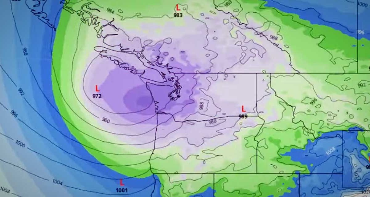
The National Weather Service issued a “Special Weather Statement” at 4:30pm Thursday (Nov. 12th), warning of a “vigorous cold front” hitting the area Friday morning, bringing rain, wind and snow to the mountains.

Could this be the first breath of ol’ man winter?

Here’s the statement:

… Active weather day expected Friday…

A vigorous cold front will pass southeast across western Washington Friday morning… bringing Rain… Mountain snows… locally windy conditions and possibly snow showers to parts of The Lowlands.

South winds in advance of the front will increase late tonight into early Friday morning… mainly along the coast and parts of the northwest interior including the Admiralty Inlet region. Wind speeds in those areas are expected to reach 20 to 30 mph with a few gusts to 45 mph… mainly in and around the Island County area. After the front passes… winds will become west to southwest down the Strait of Juan de Fuca and across the northwest interior before diminishing through the afternoon. While below Wind Advisory criteria… wind of this strength could blow down a few tree limbs here and there with isolated power outages.

Colder air will surge in behind the front and lower already low snow levels across the region. During the morning hours ahead of the front the snow level will be around 1500 to 2000 feet. The snow level will then gradually drop through the day to around 500 feet by evening. This means some of the highest hills around the region could see a few snow showers late Friday into Friday evening. However… outside of the mountains or the immediate Cascade foothills… little to no snow accumulation is expected.

Dry and tranquil weather will return to the region late Friday night into Saturday.

The National Weather Service issued a “Special Weather Statement” late Thursday afternoon (July 23rd) warning about a heat wave that will begin this weekend and last into next week, with projected highs in the 85-95 degree range.

Here’s the official warning:

… Hot weather beginning this weekend and lasting into next week…

The hottest weather of the year is likely to occur this weekend and early next week. High temperatures will be in the 85 to 95 range. Overnight lows will be in the 60s. All areas of western Washington could be affected.

The first really hot day will be Saturday or Sunday. The hottest days look like Sunday through Tuesday. At this time models predict the hot weather could last into Thursday or beyond.

Unlike many previous hot spells… this one could also affect the coast and other places near the water. Also it is rare to have many hot days in a row in western Washington… but this heat wave could last several days.

Western Washington is having a dry Summer… and no rain is in the forecast for the next week or so. Fire danger will increase during the hot weather. There is also a risk of air stagnation during this period.

The National Weather Service will issue more statements about this event over the coming days.

And according to meteorologist Cliff Mass:

“I took a look at the long-range forecasts and was shocked.

The temperature climbs through the weekend…into the lower 90s on Sunday and mid 90s at least on Monday and Tuesday.

Too far out to be sure now….but be ready for real heat.”

BTW, Cliff also adds that:

“2009 is the driest 20 May-19 Jul period on record using the combined SeaTac/downtown observations”

So…have a great weekend, but stay cool, slathered up, and be sure to check in on elderly neighbors/relatives and drink plenty of water!