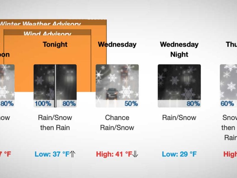
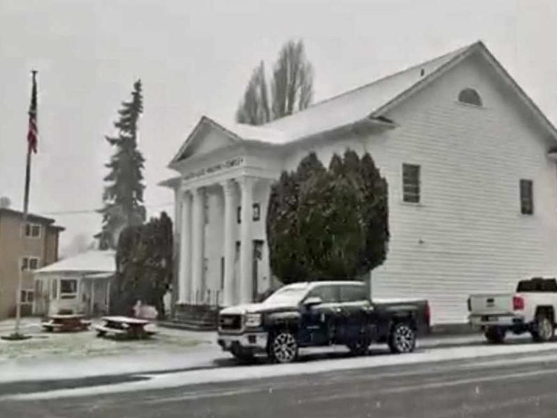
The National Weather Service has released an updated forecast for this weekend, and they’re saying we may, just possibly have a 30-40% chance of SNOW starting Friday night (Dec. 11th) continuing through Sunday.

Of course, weather prognosticators are never wrong, are they? We sure hope not.

Here’s their latest day-by-day predictions, as of 9pm Wednesday Dec. 9th, most certain to change as the clock ticks:

  • Thursday Night: Mostly cloudy, with a low around 26. East northeast wind around 6 mph becoming calm.
  • Friday: Mostly cloudy, with a high near 38. Calm wind.
  • Friday Night: A 30 percent chance of snow. Cloudy, with a low around 28. Calm wind becoming north northeast around 6 mph.
  • Saturday: A 40 percent chance of snow. Snow level 300 feet. Cloudy, with a high near 40.
  • Saturday Night: A chance of snow. Snow level 300 feet. Cloudy, with a low around 32. Chance of precipitation is 50%.
  • Sunday: A chance of rain and snow showers. Cloudy, with a high near 41.
  • Sunday Night: A chance of rain and snow showers. Cloudy, with a low around 36.
  • Monday: A chance of rain and snow. Cloudy, with a high near 42.
  • Monday Night: A chance of rain. Cloudy, with a low around 42.

Cliff Mass adds:

A lot of you are wondering about snow. I have been wondering too. The problem is that the models are not consistent for this weekend and early next week. This morning our local model forced by the GFS..the NWS’s best large scale forecast model, indicated a major snowstorm late Monday. But I don’t trust any of it at this point and you shouldn’t either. Thursday and Friday until dinnertime looks dry for western Washington…and cold. You can bank on that.

BTW, a record low of 18 was set at SeaTac Airport Wednesday morning (Dec. 9th). The previous low was 21, set in 1972.

The National Weather Service issued a “Special Weather Statement” at 4:30pm Thursday (Nov. 12th), warning of a “vigorous cold front” hitting the area Friday morning, bringing rain, wind and snow to the mountains.

Could this be the first breath of ol’ man winter?

Here’s the statement:

… Active weather day expected Friday…

A vigorous cold front will pass southeast across western Washington Friday morning… bringing Rain… Mountain snows… locally windy conditions and possibly snow showers to parts of The Lowlands.

South winds in advance of the front will increase late tonight into early Friday morning… mainly along the coast and parts of the northwest interior including the Admiralty Inlet region. Wind speeds in those areas are expected to reach 20 to 30 mph with a few gusts to 45 mph… mainly in and around the Island County area. After the front passes… winds will become west to southwest down the Strait of Juan de Fuca and across the northwest interior before diminishing through the afternoon. While below Wind Advisory criteria… wind of this strength could blow down a few tree limbs here and there with isolated power outages.

Colder air will surge in behind the front and lower already low snow levels across the region. During the morning hours ahead of the front the snow level will be around 1500 to 2000 feet. The snow level will then gradually drop through the day to around 500 feet by evening. This means some of the highest hills around the region could see a few snow showers late Friday into Friday evening. However… outside of the mountains or the immediate Cascade foothills… little to no snow accumulation is expected.

Dry and tranquil weather will return to the region late Friday night into Saturday.

Snow squalls slammed the Burien area this afternoon, chock full of hail-like snow “pellets” which turned to regular flakes which have either lightened up or stopped entirely.

The question on everyone’s mind of course is:

Will the snow continue tonight?

Will school be delayed or closed tomorrow?

The National Weather Service says there’s a 90% chance of snow this afternoon, with lows hitting the mid-20s tonight, but only one to three inches accumulation:

AN ARCTIC FRONT IS PUSHING SOUTH THROUGH THE PUGET SOUND REGION BRINGING INTENSE SHOWERY WEATHER TO THE REGION. THE FRONT EXTENDS FROM THE KITSAP PENINSULA EAST AND ARCS NORTHWARD BACK INTO SNOHOMISH COUNTY WHERE IT HAS DROPPED A COUPLE OF INCHES ON THE EVERETT AREA. SOUTHWESTERLY FLOW AHEAD OF THE FRONT IS SPARKING INTENSE SHOWERS FOR THE SOUTHERN SOUND TOWARD THE CASCADES FOOTHILLS. HAIL…SNOW AND THE OCCASIONAL RUMBLE OF THUNDER MAY BE PRODUCED BY THESE SHOWERS ACROSS THE SOUTHERN SOUND. THE FRONT WILL PUSH THROUGH THE SEATTLE METRO AREA AROUND 2 PM DROPPING A DUSTING TO 2 INCHES OF SNOW IN THE HEAVIER SHOWERS. THE FRONT WILL PUSH TO THE SOUTHERN SOUND IN THE AFTERNOON…POTENTIALLY AFFECTING THE EVENING COMMUTE.

Tuesday should be warmer, and we don’t know yet about any school closures or delays; best bet is to check www.schoolreport.org first thing in the am.

This Afternoon: Snow showers. High near 39. North northwest wind around 11 mph. Chance of precipitation is 90%. Total daytime snow accumulation of 1 to 3 inches possible.

Tonight: Scattered snow showers before 11pm. Partly cloudy, with a low around 26. North northwest wind between 9 and 14 mph. Chance of precipitation is 40%. New snow accumulation of less than a half inch possible.

Tuesday: Mostly sunny, with a high near 41. Northeast wind around 6 mph.

Here’s a closeup of the “snow pellets” that pelted B-Town around 1:30pm Monday:


Yes, it’s snowing lightly in Burien with temps in the low 30s, but as of 7am Monday morning there are no reported school delays or closures.

Here’s the latest forecast from the National Weather Service – up to an inch of snow is possible:

Today: Snow showers likely. Mostly cloudy, with a high near 40. Calm wind becoming north northwest between 7 and 10 mph. Chance of precipitation is 60%. Total daytime snow accumulation of less than one inch possible.

Tonight: A 40 percent chance of snow showers before 11pm. Mostly cloudy, with a low around 26. North northwest wind between 9 and 13 mph. New snow accumulation of less than a half inch possible.

According to the National Weather Service, we may be on the receiving end of some very cold temps and yes, maybe even snow in the Burien area over the next 24 hours, and the latest statement indicates potential precipitation in the afternoon/early evening:

Statement as of 4:59 PM PDT on March 08, 2009

…Another chance for lowland snow Monday followed by cold temperatures…

An Arctic front will slide out of the Fraser valley Monday morning… pushing south during the day. The front will drop up to a quick inch of snow as it pushes south through the northern interior Monday morning. It will likely reach the Seattle Metro area around noontime… where it will start to converge with slightly more moist air. As the front pushes into the Puget southern sound and southwest interior in the afternoon… there will be the potential for a couple of inches of snowfall.

Snow showers will come to an end from north to south on Monday… lingering into Monday evening for southern sections. Drier and colder air will quickly settle over western Washington Monday night.

Due to the Arctic origins of this airmass… record or near-record low temperatures are forecast for Monday and Tuesday night.
Temperatures will slowly moderate as the week progresses.

We’re certainly having a lively winter, and even though Spring is scheduled to start in just two weeks (March 20th), there’s a chance of snow in the forecast for Saturday night!

Here’s the statement from the National Weather Service:

Statement as of 5:36 AM PST on March 06, 2009

… Snow showers possible across The Lowlands this weekend…

A strong cold front will pass through western Washington on Saturday bringing cool and unstable conditions to the region. Onshore flow will increase behind the cold front with showers expected Saturday afternoon into Sunday. Snow levels will remain quite low…near sea level with rain possibly mixing with snow in heavier showers. Snowfall accumulations will be spotty with up to 1 inch of snow possible from stronger showers. Locally heavier amount may be found across the higher hills of King and Snohomish counties as a Puget Sound convergence zone develops Saturday afternoon through early Sunday. Heavy snow is also expected across the western slopes of the north and central Cascades.

Cool and showery weather will persist into early next week with temperatures remaining below normal. Low temperatures will be in the mid 20s to lower 30s with afternoon highs in the upper 30s to lower 40s.

Be sure to check in with The B-Town Blog if anything exciting happens, and/or email us your snow photos!

As of 6:02am Thursday Feb. 26th it’s snowing in the Burien area, and here are the latest weather-related updates:

  • HIGHLINE SCHOOL DISTRICT: 2 HOURS LATE

Updated: 5:42 a.m. February 26, 2009

Highline Public Schools will operate two hours late today. Emergency bus transportation is in effect.

*There will be no breakfast, no morning classes for preschool, kindergarten, ECEAP, or PSSC. Afternoon classes for these programs will be on time.

*Schools will dismiss at regular times.

Snow and power failures can cause disruptions for schools and families. During these difficult times, HIghline Public Schools will do all it can to communicate vital information to parents and students.

Our top priority is student safety!

  • SEATTLE PUBLIC SCHOOLS: 2 HOURS LATE:

2 Hours Late.

Buses Operate on Snow Routes.

No Door-to-Door Service.

No A.M. or P.M. Head Start.

No A.M. or P.M. Kindergarten.

Here’s the latest from the National Weather Service:

Statement as of 4:35 AM PST on February 26, 2009

… Additional snowfall of an inch or two and freezing temperatures will warrant caution this morning…

Hazardous driving conditions will be the rule across western Washington this morning due to snow that has already fallen…  possible accumulations of another inch or two… and freezing temperatures.

Scattered snow showers will continue this morning as the upper level low pressure system over the area moves eastward. Local
additional accumulations of an inch or two are possible. In addition temperatures have fallen below freezing across most of western Washington this morning… so roads and sidewalks will be icy even if they are free of snow.

These conditions will be relatively short lived. Temperatures will climb above freezing by noon today with highs around 40… and most of the area will have partly sunny skies.

If you’re going to be out driving, here are live webcam views – to get the latest view, be sure to refresh the page:

SeaTac Airport Webcam

I-5 at 188th
16th Ave SW at 107th
Hwy 99 at West Marginal Way

The National Weather Service issued the following Advisory Wed. morning about potential snow showers coming tonight/Thursday:

Statement as of 4:21 AM PST on February 25, 2009

… Local snow showers are expected over the western Washington lowlands late tonight and Thursday…

A cooler air mass will move into western Washington tonight… and it will be cold enough for showers to fall locally as snow or rain and snow mixed across the western Washington lowlands late tonight and Thursday.

Widespread snow accumulations are not expected… and high temperatures Thursday will reach the lower to mid 40s. However spotty accumulations of 1 or 2 inches are possible mainly in the northwest interior… along Hood Canal… and in the southwest interior late tonight or Thursday morning.

So be prepared…ol’ man winter might be making one final appearance!

More info/links:

A taxi driver was killed early Wednesday morning around 4:15am in a 6-car crash blamed on ice on SR-509 near SW 128th Street in Burien.

According to authorities, the driver lost control and spun out while traveling northbound on 509. He apparently then got out of his vehicle and was struck by two other drivers. He died on the scene, and his identity has not yet been released.

Police closed down the northbound lanes and diverted traffic off to the SW 128th exit while they investigated the scene.

Another person was trapped in one of the crashed cars and was critically injured.

Police advise drivers to proceed with extreme caution this morning, as freezing overnight temps have created icy driving conditions, especially on overpasses.

Somewhat surprising that it’s actually snowing in Burien now, and the National Weather Service has issued this Advisory:

… Winter Weather Advisory remains in effect until 6 PM PST this evening…

Along the I-5 corridor of King… Pierce… Thurston and Lewis counties…1 to 3 inches of snow accumulation is expected.

Heaviest snowfall will occur over the Kitsap peninsula west of Puget Sound… where 2 to 4 inches of accumulation is expected in the Bremerton area.

Precautionary/preparedness actions…

A Winter Weather Advisory means that periods of snow… sleet… or freezing rain will cause travel difficulties. Be prepared for slippery roads and limited visibilities… and use caution while driving.

For our area, they’re calling for:

  • Snow accumulation between 1 and 4 inches, contiuing tonight, with temps in the upper 30s.
  • Snow decreasing overnight. Snow accumulation up to one inch. Lows in the upper 20s to lower 30s. Southeast wind 10 to 15 mph.
  • Mostly cloudy. A chance of morning showers. Highs in the lower to mid 40s. North wind near 10 mph.

No word yet on school closures for Wednesday, but stay tuned for updates – we’ll post ‘em as we get ‘em (that is, as long as our Server holds out and the site stays online…).

Some snow in the area, but all Highline Schools are running on time today (Monday, Feb. 9th).

However, Seattle Schools are running two hours late:

  • 2 Hours Late.
  • No A.M. or P.M. Kindergarten.
  • No A.M. or P.M. Head Start.
  • No Door-to-Door Service.
  • Active Dates: 02/09/09 05:36 AM to 02/09/09 04:00 PM
  • Last Modified: 02/09/09 05:42 AM

Westside School follows Seattle Schools’ lead (with a scheduled 9:30am start time), but we just got an email from them and they’ll be opening on time.

Jan ’09
31
8:00 am

Burien Parks is sponsoring a special family snowshoe outing this Saturday, Jan. 31st at Snoqualmie Summit, leaving Burien at 8am.

Here are the details:

WHAT: Family Snowshoe Outing

WHEN: Saturday, Jan. 31st, leaving B-Town at 8am

WHERE: Snoqualmie Summit

WHO: Adults must be accompanied by a child 7 years or older.

COST: $20 per person

INFO: As of 1/25/09 there were still 11 spots available, so act fast! “Come spend some quality time together doing an activity the whole family can enjoy! Snowshoeing is one of the fastest growing, easiest to learn, and healthiest winter activities. Leave the driving to us!”

REGISTER: Call (206) 988-3700 to register or for more info: CLICK-N-GO

Numerous Burien-area residents were in the dark Sunday night, and it wasn’t just because the sun went down – Seattle City Light reports that power was lost last night around 8pm to nearly 3,900 homes.

According to Mike Eagan of Seattle City Light, there were two outages overnight, both caused by falling tree branches laden with heavy snow:

1. Boundaries – 1/4/2009 8:03:00 PM:

  • North – S Barton St;
  • South – SW 152nd St;
  • West – Puget Sound;
  • East – 10th Ave S;
  • Approximate customers affected: 3899
  • Cause: UNKNOWN It was a Tree
  • Estimated power restoration time for the above outage: January 5, 2009 at 6 a.m. 100% power restored at 1:28am 1/5/09

2. Boundaries – 1/4/09 early am (time unknown):

  • North – S. 96th
  • South – SW 175th
  • West – 24th SW
  • East- 33rd SW
  • Cause: Tree
  • 95% power restored as of 9:25am 1/5/09

6:15am UPDATE 1/5/09: :Last night’s snow is melting (or has melted depending on where you are), and it looks like all Highline Schools are operating on a normal schedule, with NO delays.

  • However, JFK High School will be starting LATE – at 10:30am.
  • Most King County Metro Transit buses are on their regular routing for Monday morning, but some will be chained. This could cause some service delays as the buses travel more slowly across both slushy and bare roadways. Metro riders to check service status online or by calling (206) 553-3000 before traveling today.
  • Today’s weather forecast shows NO SNOW: “Scattered showers. Mostly cloudy, with a high near 47. West southwest wind between 10 and 15 mph. Chance of precipitation is 50%.”

UPDATE 10:30pm 1/4/09: Looks like the sudden rush of heavy snow showers is fading and/or turning to a wet mix, so perhaps both garbage collections and school will go on as normal on Monday.

Outside The BTB Home HQ (near sea level) we received just over an inch of the stuff, which was very heavy and wet – not a good mix for branches and power lines; in fact, we heard of some sporadic power outages around Burien, including the Seahurst neighborhood around 9:30pm.

Be sure to check here Monday morning for the latest weather, school and road closure updates, and in the meantime, enjoy another exciting winter’s night!

PREVIOUSLY:

UPDATE 7pm 1/4/09: Okay, so perhaps we’ll be wrong about tonight’s snow, but according to the precipitation prognosticators, the snow is supposed to turn into rain late tonight/early tomorrow.

However, that hasn’t stopped the National Weather Service from posting this Winter Weather Advisory, which is in effect until 9pm tonight:

… Winter Weather Advisory in effect until 9 PM PST this evening…

The National Weather Service in Seattle has issued a Winter Weather Advisory… which is in effect until 9 PM PST this evening.

Snowfall amounts of 1 to 3 inches are likely across the Seattle… Tacoma and Everett areas… with snow changing over to rain later this evening.

Precautionary/preparedness actions…

A Winter Weather Advisory means that periods of snow will cause travel difficulties. Be prepared for slippery roads and limited visibilities… and use caution while driving.

PREVIOUSLY: It’s snowing again in Burien, but don’t worry folks – even though tomorrow is the first day back at school for kids, our patented B-Town Blog Weather Rock™ predicts that temps will be in the upper 40s tomorrow will change everything to rain as well as prevent any rash decisions by school officials.

However, one never knows with the weather ’round these parts, so be sure to check back and watch the webcams we’ve got posted here, and be sure to refresh the page to see the latest images:

Well, the snow and ice are gone, but, unfortunately for some, automotive dings and dents that may have accumulated over the past week or three “live on.”

Well, here’s a note from BTB Advertiser Amy Driscoll at Vision Collision Auto Body Repair:

Come on in!

Amy and husband Michael have years of experience in the auto body repair business, and they are happy to help you out in speedy fashion.

They are conveniently located just west of Ambaum at 803 SW 154th (see map below).

Call them at 206-244-2758, or visit their website at www.visioncollision.net.

And remember their slogan: “See? You’re Dent Free!”


View Larger Map

King County announced today that they’re offering assistance for property and business owners who suffered damages due to our recent winter weather.

Here’s the announcement in its entirety:

Property and business owners who had losses due to the recent winter weather may be eligible for assistance getting their property back in order. Eligibility is determined through a damage assessment process which takes into account total reported losses within King County.

Impacts of winter weather, such as snow load and flooding, may have resulted in individual property damages or business losses. King County homeowners and small business owners who have suffered damages from recent weather related conditions should file a damage report with King County Office of Emergency Management within the next two weeks.

A hotline number (800-523-5044) has been established for reporting damages within King County and is open during the following dates and times:

Dec. 29 – Dec. 31, 2008
8:30 a.m. – 4:00 p.m.
Jan. 5 – Jan. 9, 2008
8:30 a.m. – 4:00 p.m.

Before filing a damage report with OEM, citizens should contact their insurance company about existing coverage. They are also urged to document damages with photographs and keep records of all clean-up and repair costs.

In addition, business owners who have incurred weather-related economic losses should submit an Economic Injury Disaster Loan Program form to the Office of Emergency Management (fax# 206-205-4056). The form can be downloaded from the Washington Emergency Management Division’s website (http://emd.wa.gov/disaster/documents/EconomicInjuryWorksheetnew9-2007.pdf).

For more information, contact the Office of Emergency Management or visit the office website (http://www.kingcounty.gov/safety/prepare.aspx).

by Shawn Underwood

If I do say so myself…ahem, I am an unusually calm and cool driver.

Even in the calm and cool snowstorm we just survived.

Unforeseen curbs, sidewalks and even an errant jaywalker rarely cause me any distress.

However, this last week, I cannot contain myself any longer – Burien drivers (and you know who you are!) are summarily grounded when the snow falls!

RANT: DO NOT drive in the snow unless you know what the ‘H-E-Double-Toothpick’ you are doing!

Snow accumulation of one-inch or more constitutes a universal ”inept snow driver stay at home” grounding. This rule must be enforced by all police officers on patrol. I don’t care if you are having a much-needed coffee break in U.U. office at Starbucks, get out there and control the mayhem! Underwood-Undercover is willing to make a Citizen’s Arrest whenever her services are needed. No need for the errant driver to know that she officially deputized herself, like some arrogant female Barney Fife (a great role model if ever there was one).

RANT: A slick tire is a type of tire that has no tread pattern; these tires are used on RACECARS, not your Volvo! DO NOT attempt to drive in the sleet and slush with worthless wheels on your ancient Volvo, dude.

RANT: Under no circumstances can a weak driver with the dribbles back down (more like slide sideways) a giant hill to try again and “get a run at it.” Other competent, strong forces are trying to get up the hill.

RANT: Plan ahead you boofus, especially if Grandpa Joe is driving in geezer gear ahead of you. Use the horn man, and slip-slide your way around him. Oncoming traffic can be flashed off with multiple blinks of headlights. Again – it’s every (snow)man for himself.

RANT: Pedestrians – get the ‘H-E-Double-Toothpicks’ off the main road. Put on your freakin’ snow boots and walk (trudge) on the non-existent sidewalk. I know it’s hard going but it’s better than being run over by “Mr. Volvo Slick Tire.”

RANT: Do not stop in the middle of the already very narrow plowed main road to “help” a motorist stuck in the snow bank in the center of the road. For Gawd’s sake man, how are the other drivers supposed to: first of all stop, and second of all, get around you? Being an upstanding citizen does not negate using common sense!

Underwood-Undercover cannot think of any actual Raves with regards to driving in the snow; but sledding in the snow = plenty of raves.

RAVE: To U.U.’s daughter, who found an awesome steep driveway with plenty of trees to dodge (more exciting) and zero sledders competing for the steepest path. Way to go!

RANT: The very steep hill of Tuffie’s 1 and 2 (an aforementioned columnist’s favorite neighborhood dogs) is awesome for sledding, but dude! Where is the lookout on the bottom of the hill? U.U. has twice narrowly missed snow-blind boarders sliding right onto Maplewild.

As I look at my column now, I see that I have only one Rave.

Sad but true, but remember a Driver (especially a lame-o snow driver) is a “club with a wooden head.”

Twenty-five years of living in Burien gives Humorist Shawn Underwood much fodder for her writings.

All of her stories are true, or at least have a grain of truth with no added embellishments.

Or something like that.

Read more of her humor at her website here.

Monday (Dec. 29th) will be the first garbage and recycling pickup day for a lot of Burien residents in two weeks, so get your containers out there, and remember – triple volume accepted!

Here’s the latest from Waste Management:

Residential service for Monday garbage customers and those scheduled for recycling and/or yard waste service today. If this is not a regular recycling or yard waste collection week, customers will need to wait for service until the week of Jan 5-9.

Double/triple volume accepted; Tips for Managing Extra Garbage & Recycling.

Please remove snow from on top of and around containers. If your street is still snowy, please move your containers to a more accessible location for service.

CONTACT INFO:

Email: info@wmnorthwest.com
Phone:
1-800-592-9995
Fax:
1-866-284-1337

City of Burien Garbage and Recycling Help Line: 206-933-0992

We’ve got ours out, neatly arranged in triplicate and ready to go…have you?

There will be NO garbage/recycling collection in Burien Saturday or Sunday (12/27-28), with up to triple amounts of stuff accepted during the next pickup.

Here’s the latest update from Waste Management (more info available at their website here):

Saturday, December 27, 8:00 AM: Unsafe road conditions have unfortunately required Waste Management to once again postpone residential curbside collection in Snohomish County and most of King County, including Burien, Renton, and all East King County areas.

No residential collection will be provided on Sunday, as previously reported. Waste Management needs to preserve driver time for long work hours next week as we clean up the accumulated material resulting from numerous collection delays.

King County residents outside the City of Seattle may take garbage and recycling to King County transfer stations, including:

  • Bow Lake in Tukwila
  • Enumclaw
  • Renton
  • Factoria
  • Houghton
  • Shoreline

Call 206-296-4466 or visit http://your.kingcounty.gov/solidwaste/facilities/transfer.asp for addresses and hours.

Remove Snow Accumulation. To keep containers accessible, please remove snow and extra material from around or on top of them.

Clear Storm Drains to Prevent Street Flooding: As snow melts, water run-off can result in flooding, which further impedes collection. Please clear storm drains of snow and debris to prevent flooding.

Tips for Extra Material Storage and Set Out: Waste Management suggests that residents use the following options for storing and setting out extra materials:

Extra garbage: Place next to garbage container in:

  • Securely tied plastic bags labeled “Garbage” or
  • 32-gal can with handle and lid (65 lb limit) labeled “Garbage”

Extra recycling: Place next to recycling cart in:

  • Plastic recycling bins or
  • Cardboard boxes (2×2x2 ft. limit) labeled “Recycling”
  • No recycling in plastic bags

Extra yard trimmings (No food scraps or plastic): Place next to yard cart in:

  • Heavy paper yard bags (available at hardware stores) or
  • Reusable polywoven yard bags (available at hardware stores) or
  • 32-gal cans with handles & lids (65 lb limit) labeled “Yard” or
  • Bundles tied with sisal twine (4′x2′ limit)
  • Only patches of snow remain in the Burien area Saturday (some side roads may still be slushy), and proof that it is melting lies above in the sad crime scene photo of a one-time Snowman’s remains found on an area lawn.

    But fear not B-Towners, for we all know that Frosty will return again.

    The only question remains: how soon?

    What we do know is:

    • The rain will continue for the next several days with highs in the 40s.
    • A Flood Watch is still in effect for small streams in King County; here’s the warning from the National Weather Service:

    Rain locally heavy at times will persist through tonight. Rainfall amounts of a half to one inch with locally higher amounts on the coast are likely by Sunday morning. This combined with melting snow across The Lowlands or elevations below 2000 feet will likely result in some urban or small stream flooding. Residents in urban areas are strongly encouraged to clear any blockages of storms drains before it causes flooding problems.

    Excessive runoff from rain and snow melt will cause ponding of water on highways… streets and underpasses… in urban areas with poor or overwhelmed drainage… and will also cause elevated levels on small creeks and streams.

    Do not underestimate the power of flood waters. Only a few inches of rapidly flowing water can quickly carry away your vehicle.

    Sure, there aren’t any major rivers running through the Burien area, but we do have some significant creeks (ie: Miller & Walker Creeks), so everyone should make sure to clear any storm drains near your home, and if you’re near any of the above-mentioned creeks, please check on them and make sure they’re flowing well.

    Here’s the official Flood Watch warning:

    … Flood Watch remains in effect through Sunday morning…

    * a Pacific storm will bring warmer air and raise the snow level significantly. The combination of increasing southerly winds… milder temperatures… and rain on snow will result in rapid snow melt across The Lowlands tonight and Saturday. There is also the potential for minor flooding of the Skokomish River Saturday as the snow level climbs to near 5000 feet on the olympic range.

    * The combination of rain and melting snow across The Lowlands could result in urban and small stream flooding… especially in those areas where a foot or more of snow was still on the ground. Snow and ice may result in clogging of storm drains that could result in flooding of streets and… possibly…homes and businesses.

    * The Chehalis river and its tributaries could also approach or exceed flood stage. Up to two feet of snow covers the Chehalis watershed and it will all likely melt by Sunday. That water… along with the rain… will cause the rivers of southwest Washington to rise significantly.

    Precautionary/preparedness actions…

    A Flood Watch means conditions are favorable for flooding but flooding is not imminent or occurring. Monitor the latest forecasts from the National Weather Service and be ready to act quickly if flooding is observed or a warning is issued.

    And remember – if you have any interesting weather-related photos to share, please either email us or add ‘em to our Flickr Group so we can share them!

    Garbage/Recycling provider Waste Management says that there will be NO pickups Friday, Dec. 26th in the Burien area, although they will allow “up to triple volume accepted next regular collection day for each missed curbside container.”

    Here are some snippets from their latest update:

    Holiday Collection Schedule Friday and Saturday weeks of Dec 25 & Jan 1:

    Friday, December 26:
    (although there will be no pickup today…), Waste Management’s Customer Service Center will be open from 8 AM – 5 PM:

    Because of weather delays, we expect phone lines to be extremely busy, resulting in long waits.  The alternatives below will help customers get information quickly:

    • Double Triple volume will be accepted on the next regular collection day for each missed residential container. If a container is missed twice, triple volume will apply.
    • If you have too much material to fit in your containers, check our Tips for Managing Extra Garbage and Recycling.
  • You can e-mail Customer Service regarding specific concerns by locating your city or county contact address on the menu provided.

  • Carolyn Rosenfield found an easier way to get around Burien – by cross country skiing on SW 172nd in 3 Tree Point. Photo by John Naubert.

    10:45am 12/24/08 UPDATE: The soggy rain transition period continues, and with it comes potential new dangers like clogged storm drains, slushy roads, large walls of plowed, heavy snow and excessive roof loads.

    Some updates:

    • The City of Burien’s offices will be open until 2pm this afternoon.
    • All Burien Parks and Recreation programs are canceled for the week.
    • Far as we know, most restaurants in Burien are open today (including The Mark)
    • Normandy Park residents have until 3:30pm to haul their own garbage/recycling to one of two locations for disposal (think of yourself as Santa; read this post here for details)
    • Metro Transit is focusing on core service until weather and road conditions improve, which means bus service will be significantly limited during the weather emergency. Information about bus status is available on Metro’s Ice & Snow page, which is updated frequently. You can also call the Metro Customer Information Office at (206) 553-3000, but call volumes are high and there may be a wait to talk to a CIO representative.
    • Burien’s garbage & recycling service has been canceled for today, Dec. 24 (Waste Management) http://www.wmnorthwest.com/weatherboard.html
    • Residents are advised to avoid piling snow on top of storm drains when shoveling sidewalks and driveways. Storm drains need to be kept clear, so when the snow melts the runoff has some place to go. Residents are encouraged to clear snow from storm drains, when streets are clear of cars, after snow and ice starts to thaw. Clearing snow from storm drains will help to reduce the amount of localized flooding, which is likely to occur based on weather forecasts of warming temperatures and rain.

    Here’s some info from the City of Burien’s website on excessive roof loads:

    Recent weather conditions in the region resulting in abnormally heavy snowfalls may result in excessive roof loads on buildings due to the accumulation of snow and ice.

    The series of snow storms that have hit the state have left several inches of snow and ice on roofs, which have added to the total weight that trusses and rafters must support. A cubic foot of snow can weigh from seven pounds for snow that is new and dry up to 30 pounds for old, compacted snow. Rain falling on accumulated snow will add even more weight. The combination of these factors and the recent forecast which calls for more snow and rain over the next couple of days may cause an excess of snow loading on many roofs.

    Watch for Early Warning Signs of Overloading:

    • Be on the watch for these warning signs:
    • Severe roof leaks, indicating torn roof membranes.
    • Ripples or bends in metal supports.
    • Loud popping noises emanating from the building structure.
    • Water ponds in areas where it never accumulated before.
    • Obvious deformities in the roof.

    What to do if you Suspect Overloading
    When snow removal is necessary, it should be remembered that unsafe procedures may cause a collapse and injuries. Anyone working on a roof must have adequate fall protection and keep in mind that workers and others nearby can be injured by snow being dumped from a roof.

    Once it has been determined that the snow must be removed, there are several options for snow removal.

    Most roofing contractors are equipped to handle snow removal from the roof of your home and buildings.

    Another option is to remove the snow yourself. The best way to do this is to get up on your roof and push the snow off with a broom or shovel. It is important to use ladders, safety ropes and take necessary precautions.

    Snow rakes also can be used to remove snow. When using a snow rake, use extreme caution when working near overhead electrical power lines. Also, avoid excessive scraping on the roof or trying to chip off any ice.

    And finally, here’s a cool website where kids of all ages can watch Santa’s progress as he delivers his goodies around the world:

    Normandy Park residents who are fed up with having to store their own garbage and/or recycling can actually dispose of their stuff today (Wed. 12/24) between 9am and 3:30pm, if they can get out that is.

    Here’s an update from Allied Waste/Republic Services:

    Allied Waste/Republic Services Emergency Service Alternative for Normandy Park

    In recognition that the extended inclement weather has created storage issues for garbage and recycle commodities, the Bellevue Division is offering a temporary solution:

    Today Normandy Park has agreed to provide access to two community sites where residents who wish to utilize this opportunity to dispose of their recyclables and garbage may do so. These sites are cleared of snow and will allow Allied Waste /Republic Services to spot attended vehicles so residents can dispose of household recyclables and garbage.

    • This service will be available from 9 AM till 3:30 PM, Tuesday Wed., December 24, 2008
    • One vehicle will collect garbage only and another will collect recycle only
    • Waste Service employees will monitor for contamination and customer compliance

    Site 1 is the loop drive and parking lot area in front of City Hall, just off of SW 174th where we placed the container after the windstorm two years ago.

    Site 2 is the parking lot at Marvista Park next to the Public Works shop at 19900 4th Avenue SW.

    Lake Burien is still partially frozen Wednesday morning, with a fresh dusting of scenic snow. Photo by Gregory Rehmke.

    Looks like we’re in the icky weather transition period where the snow turns into rain (depending on where you live – we’re near the water and it’s raining here), and the roads become a huge slushy mess – a perfect day to clear any and all storm drains near your house, as the next phase will involve lots of water.

    There’s still a Winter Weather Advisory in effect until 4pm today:

    The Winter Weather Advisory is now in effect until 4 PM PST this afternoon.

    Snow is expected to continue this morning. By late morning or early afternoon the snow will change over to rain in locations below 500 to 1000 feet. The higher hills continue with snow through this afternoon.

    Up to two inches of new snow is possible before the change over to rain. Higher amounts are possible on hills above 500 to 1000 feet.

    Snow showers could bring additional accumulations late tonight and on Christmas day.

    Precautionary/preparedness actions…

    A Winter Weather Advisory for snow means that periods of snow will cause primarily travel difficulties. Be prepared for snow covered roads and limited visibilities… and use caution while driving.

    More BTB Reader photos to share – first, Jessica Gran’s pics of a homemade igloo; she says:

    “The kids had enough snow to make an igloo, with two brick walls protecting the entry way.

    The ultimate fortress for a snowball fight!”

    Then, from Virginia in the Hurstwood neighborhood comes this photo of one of her lit-up lawn reindeers doing its best “ostrich impression” with its head in the snow:

    Have any cool snow/ice photos to share?

    Please either email us or add ‘em to our Flickr Group so we can share them!

    3:30pm 12/23/08 UPDATE: As of 3pm, the National Weather Service released this Winter Storm Advisory – 2 to 4 inches of snow are expected Wed. Dec. 24th, with a transition to rain also:

    … Winter Weather Advisory in effect from midnight tonight to 4 am PST Thursday…

    The National Weather Service in Seattle has issued a Winter Weather Advisory for snow… which is in effect from midnight tonight to 4 am PST Thursday. This upgrades the Winter Storm Watch which had been in effect.

    Snow is expected to begin after midnight tonight and continue through Wednesday morning. The snow will be light at first but then increase its intensity on Wednesday morning. Late on Wednesday morning or early in the afternoon… locations below 500 to 1000 feet will transition to a cold rain… while higher hills continue with snow through Wednesday afternoon.

    Snowfall totals of 2 to 4 inches are expected. Significantly higher amounts are possible on hills above 500 to 1000 feet or anywhere that precipitation might continue as snow through the afternoon and evening.

    Snow showers could bring additional accumulations on Christmas day.

    Precautionary/preparedness actions…

    A Winter Weather Advisory for snow means that periods of snow will cause primarily travel difficulties. Be prepared for snow covered roads and limited visibilities… and use caution while driving.

    Also, this update about garbage collection in Normandy Park:

    Garbage Collection
    Allied Waste has not been able to collect residential garbage and recycling due to road conditions. City staff and Allied Waste have arranged for residential drop off services at two locations in Normandy Park.

    Residential customers will have access to collection vehicles/containers for residential garbage and recyclables on Wednesday, December 24th from 9:00 a.m. to 3:30 p.m. at the locations below:

    City Hall Parking Lot – 801 S.W. 174th Street

    and

    Marvista Park Parking Lot – 19900 4th Avenue S.W.

    Regular collection services will resume when road conditions improve and collection vehicles are able to safely operate on residential streets.

    11:15am 12/23/08 UPDATE: Looks like another snow storm is coming tonight (Tues. 12/23), with up to six more inches of snow predicted to fall overnight.

    Perhaps we will indeed have a “White Christmas” after all?

    AREA UPDATES:

    • City Hall and the Parks office will be open today until 2pm.
    • Burien Parks and Recreation programs are cancelled for today.
    • No garbage/recycling pickup today (more details here).
    • Road crews continue to plow and sand streets starting with main arterials and moving to secondary streets when they are able.  More details about priority routes can be found on our Snow & Ice Routes Map [PDF].  Please drive with extreme caution and only if necessary.

    WEATHER UPDATE:

    Here’s the latest Winter Storm Watch from the National Weather Service:

    … Winter Storm Watch in effect from late tonight through Wednesday evening…

    The National Weather Service in Seattle has issued a Winter Storm Watch… which is in effect from late tonight through Wednesday evening.

    Another low pressure system is expected to drop southeast into the Pacific northwest late tonight into Wednesday. A relatively cold air mass will be in place ahead of this system. With the cold air in place… up to another six inches of new snow is possible by Wednesday evening with the snow beginning sometime late tonight. As the system moves through… the low level wind flow will become southwesterly. This should warm up the air mass enough to change the precipitation from snow to rain. This transition is expected to occur Wednesday afternoon but there is plenty of uncertainty surrounding the timing of this transition if it even occurs at all.

    Precautionary/preparedness actions…

    A Winter Storm Watch means conditions are favorable for severe winter weather. If you must travel in the watch area… carry an extra flashlight… food… water… and blankets in case of emergency.

    Live webcam view from Sea-Tac Airport.
    Refresh page to get latest image.

    Also, according to the Port of Seattle, Sea-Tac Airport’s stranded travelers are starting to clear out, which must be a relief for everyone who got stuck there.

    A local tech Writer named John Cook got stranded at Sea-Tac for seven hours, and here’s a snippet from his blog:

    Seven hours.

    That’s how long my fellow passengers and I spent waiting on the airport tarmac Sunday as an uncharacteristic winter blast brought SeaTac airport to a grinding halt.

    Here’s a link to his interesting first-hand account.

    And here’s an update from the Port on the current airport conditions:

    The airport is open and the runways are clear for operations. The situation is improving, but there are still flight cancellations and delays. Please check with your airline before starting for the airport. You can also check your flight status online (http://hosting.portseattle.org/fids/FlightInfo.aspx) on the Port’s Web site or via text messaging.

    If your scheduled flight is canceled, rebook travel over the Internet or over the phone; do not come to the airport. Long lines at the ticket counters make it more efficient and quicker to rebook off-site.

    If a scheduled flight is planned to depart, allow extra travel time to the airport to accommodate challenging regional road conditions and lines at ticket counters and security checkpoints. Plan to arrive at the airport two hours before departure time. It’s a good idea to bring necessary items (diapers, snacks, etc.) in case there are delays and/or long wait times. Airport concessions are open, stocked and prepared to serve.

    The airport is continuing to provide volunteer staff in the terminal to assist passengers, answer questions, and assist with line control / crowd control issues.

    Here are some more great BTB Reader snow photos culled from our Flickr Pool:

    “Looked like steam was rising out of the water.” Photo by B-TownMom.

    “Checking out how the B-Town Blog car held up under the snow.”
    Photo by B-TownMom.

    “Winter Photo Jaunt.” Photo by ericagirlwonder.

    And here’s a slideshow of snow on Lake Burien from BTB Reader Gregory Rehmke:

    Have any cool snow/ice photos to share?

    Please either email us or add ‘em to our Flickr Group so we can share them!

    Just got some info from Jenn Ramirez-Robson of the City of Burien, who forwards us this update from Waste Management on Burien-area garbage and recycling pickup (missed again today but scheduled for another try next week, when you can put out TRIPLE the amount of garbage and recycling as usual):

    Monday, December 22 – Due to inclement weather, Waste Management has cancelled collection services for their customers in King, Snohomish, Kitsap and Skagit Counties.

    Please note that our call center will not be open until it’s safe for our employees to return to the office.

    For the most up to date status of your service we urge you to go to our website: www.wmnorthwest.com/weatherboard.html.

    Residential customers: Twice the regular amount of garbage, recycling and/or yard waste will be accepted at no additional charge on the next regularly scheduled collection day for each container. If your next regularly scheduled collection falls on a holiday, Waste Management will collect the following day. For example, due to Christmas, this week’s Thursday customers will be serviced on Friday and Friday customers will be serviced on Saturday.

    Residential customers in the City of Seattle: If inclement weather causes missed collections for one day, missed customers will be picked up the following day and all other residential collection will be pushed back one day. If two consecutive collection days are cancelled due to inclement weather, customers may set out a double load on their next scheduled collection day.

    Commercial customers. Priority service is given to locations such as hospitals and restaurants where public health is a high priority. All other commercial customers will be serviced as soon as conditions allow for safe collection.

    Waste Management is committed to providing reliable collection for all customers. However, in the event that circumstances such as unsafe roads interfere with service schedules, we appreciate customer understanding and cooperation as we manage collection on emergency scheduling.

    Waste Management customers are strongly encourages to visit our website for up-to-the-minute collection updates www.wmnorthwest.com/weatherboard.html.

    If garbage is missed twice, residents may put out three times as much on the third scheduled collection day.  We certainly will do all we can to keep that eventuality to a minimum!

    We are also using outdial phone calls to help keep residents as well informed as possible.

    Reminders about how to package extras:

    If recycling or yard waste is regularly collected every other week, the missed material will be collected on the next scheduled day for that container (two weeks from the missed collection), unless residents are otherwise notified by telephone or on this site.

    Extra garbage: Place next to garbage container in:

    • Securely tied plastic bags labeled “Garbage” or
    • 32-gal can with handle and lid (65 lb limit) labeled “Garbage”

    Extra recycling: Place next to recycling cart in:

    • Plastic recycling bins or
    • Cardboard boxes (2×2x2 ft. limit) labeled “Recycling”
    • No recycling in plastic bags

    Extra yard trimmings (No food scraps or plastic): Place next to yard cart in:

    • Heavy paper yard bags (available at hardware stores) or
    • Reusable polywoven yard bags (available at hardware stores) or
    • 32-gal cans with handles & lids (65 lb limit) labeled “Yard” or
    • Bundles tied with sisal twine (4′x2′ limit)

    Live webcam view from Sea-Tac Airport.
    Refresh page to get latest image.

    Sea-Tac Airport is apparently jammed full of people stuck as the result of numerous flight cancellations and delays.

    Apparently Alaska and Horizon Airlines resumed limited service Monday after thousands of stranded travelers spent the night at the airport, where hundreds of flights have been canceled since Friday.

    If you’ve got travel plans and want to get the latest information, we recommend a two-pronged approach using both your telephone and internet:

    1. Call your airline via the number listed below (or on your itinerary/ticket).
    2. At the same time, try accessing the Port of Seattle’s travel info website or your specific airline’s website.

    So basically, you’ll have a phone in your ear while you surf the web, and eventually you’ll either get through or you’ll get your update. Just don’t give up.

    Here’s the latest update from the Port of Seattle (access their airport travel info website here):

    The airlines continue to face a number of challenges during this weather event.

    Many flights been canceled.  Please check your flight before coming to Sea-Tac Airport.

    See contact information below:

    • Aeromexico 800 237-6639
    • Air Canada (including Air Canada regional airlines) 800 247-2262
    • Air France 800 237-2747
    • AirTran Airways 800-247-8726
    • Alaska Airlines 800 426-0333
    • American Airlines 800 433-7300
    • Asiana Airlines 800 227-4262
    • British Airways 800 247-9297
    • Continental Airlines 800 525-0280
    • Delta Air Lines 800 221-1212
    • EVA Air 800 695-1188
    • Frontier Airlines 800 432-1359
    • Hainan Airlines 888 688-8813
    • Hawaiian Airlines 800 367-5320
    • Horizon Air 800 547-9308
    • JetBlue Airways 1-800-JETBLUE
    • Korean Air 800-438-5000, (206) 241-1576
    • Lufthansa Airlines 800 399-LUFT
    • Midwest Airlines 800 452-2022
    • Northwest Airlines 800 225-2525
    • Scandinavian Airlines 800 221-2350
    • Southwest Airlines 800 435-9792
    • Sun Country Airlines 800 359-6786
    • United Airlines (including United Express) 800 241-6522
    • US Airways 800 428-4322
    • Virgin America 877 359-8474

    The white blanket is really covering up the Brrrien area today (including the B-Town Blogmobile above), with upwards of over a foot of snow, and here are some updates to keep in mind as you either continue to hunker down or dare to go out:

    SEA-TAC AIRPORT UPDATE:

    • Some flights are resuming, others remain canceled. Best bet is to check the Port of Seattle’s airport website here (note: their website appears to be overloaded so be patient). Here’s a statement from that site: Many airlines have suspended or canceled flights, while others are continuing to operate. Travelers should check with their specific airlines for schedule confirmations or changes. Inclement weather at several other major airports has caused delayed arrivals and departures, causing the airlines to have aircraft at the wrong airports for scheduled flights (i.e. if an expected flight from Denver didn’t arrive at Sea-Tac as scheduled in the evening, it cannot depart in the morning).

    SCHOOL CLOSURES:

    • We’re sure you’re aware of this, but just in case – ALL PUBLIC & PRIVATE CHILDREN’S SCHOOLS ARE CLOSED, as it’s now Winter Break.
    • Highline School District’s Admin offices are also CLOSED.
    • South Seattle Community College is CLOSED.
    • Highline Community College is CLOSED.

    CITY OF BURIEN:

    • Burien City Hall will be open for limited hours, 10:00am – 2:00pm on Monday, Dec. 22 and Tuesday, Dec. 23. Please check http://www.burienwa.gov for weather related closures and information.
    • All Burien Parks and Recreation scheduled programs have been canceled for Monday.
    • Road crews continue to plow and sand streets as snow has continued to fall, starting with main arterials and moving to secondary streets when they are able.  More details about priority routes can be found on our Snow & Ice Routes Map [PDF].  Please drive with extreme caution and only if necessary.

    CITY OF NORMANDY PARK:

    • Normandy Park’s City Hall is CLOSED today due to weather and travel conditions. City Hall will open late on Tuesday, December 23rd at 10:00AM and close at 2PM.
    • Road crews reported most of the main routes have been plowed and sanded.  Please drive with extreme caution and only if necessary.

    LIBRARY UPDATES:

    • Far as we can tell, both the Burien and White Center library branches are open today from 10am-9pm.
    • More info on library closures available here.

    OTHER CLOSURES:

    • Garbage & recycling service has been CANCELED for today; Waste Management says: “Double volume next regular collection day for each missed container” when in fact it would be TRIPLE VOLUME!; more info here: http://www.wmnorthwest.com/weatherboard.html
    • King County District Court will be CLOSED.

    METRO BUS SERVICE:

    • Once again due to the weather and dangerous driving conditions, King County Metro Transit will be operating approximately half of its normal bus service for Monday, Dec. 22. Information about bus status is available on Metro’s Ice & Snow page, which is updated frequently. You can also call the Metro Customer Information Office at (206) 553-3000, but call volumes are high and there may be a wait to talk to a CIO representative.

    OTHER TIPS/COMMENTS:

    • To see live road conditions via webcam feeds, go to our Webcams page.
    • If you haven’t started your car since the snow first fell, you should start it up. Also, wipe off the windshield and do NOT turn on your wipers, unless your windshield is warmed up and there’s no ice around them – turning on frozen windshield wipers can strip the gears and thus ruin them.
    • Make sure your pets are okay. BTB Reader Katie Hicks sends us this email: “Could you please remind people that it is FREEZING outside and they should let their pets that live outdoors IN! It is making me sick to my stomach that I have seen dogs sleeping outside!”

    Some great night-time photos courtesy of BTB Readers Brooke & Andrea Trisler, taken in Burien Sunday Dec. 21, 2008:

    Welcome to Bedford Falls – er, we mean Olde Burien.
    You practically expect to see Jimmy Stewart running
    down the street yelling at everyone…

    There’s just something about snow, neon and
    holiday lights at night that warm your heart…

    Have any cool snow/ice photos to share?

    Please either email us or add ‘em to our Flickr Group so we can share them!


    5:30pm 12/21 UPDATE: Snow’s still falling, and by our estimations a grand total of 7-1/2 inches are on the ground now near our home office. That means that an additional 2-1/2 to 3 inches fell since yesterday afternoon, including a hard layer of ice that’s now under about 1-2 inches of snow.

    And get this – some are predicting an additional 5-8 inches overnight!

    Also, due to this event, Alaska Airlines has canceled all Alaska and Horizon airlines flights into and out of both Seattle and Portland. More info at the Port of Seattle’s airport website here.

    Here are some selected weather warning snippets, as well as the latest Winter Storm Warning:

    TONIGHT: Snow this evening will give way to lingering snow showers late. Low 28F. Winds E at 5 to 10 mph. Chance of snow 70%. Snow accumulating 2 to 4 inches.

    MONDAY: Intermittent snow showers, especially early. Temps nearly steady in the low to mid 30s. Winds NNE at 5 to 10 mph. Chance of snow 40%. Snow accumulations less than one inch.

    … Winter Storm Warning in effect until 4 am PST Monday…

    The National Weather Service in Seattle has issued a Winter Storm Warning… which is in effect until 4 am PST Monday. The Winter Weather Advisory is no longer in effect.

    An additional 3 to 6 inches of snow is expected through tonight in the Puget Sound lowlands and the lower Chehalis valley. A few isolated locations could receive as much as 8 inches. Snowfall amounts will be variable from location to location.

    Precautionary/preparedness actions…

    A Winter Storm Warning for heavy snow means significant snowfall is occurring or imminent. Snowfall intensities will be heavy enough to reduce visibilities to near zero at times.

    Here’s an earlier update from the City of Burien:

    No major power outages overnight in Burien
    City staff continue to monitor weather conditions. Please check back for weather related closures and information. The weather forecast still calls for more snow, ice and cold temperatures. Go to www.weather.gov/seattle for updated forecasts and weather warnings.

    Road crews have plowed and sanded most of the main arterials and are working on the secondaries.  More details about priority routes can be found on our Snow & Ice Routes Map [PDF].

    Metro Bus Service:
    Once again due to the weather and dangerous driving conditions, King County Metro Transit will be operating approximately half of its normal bus service for Sunday, Dec. 21 and will run three Seahawks shuttles.Information about bus status is available on Metro’s Ice & Snow page, which is updated frequently. You can also call the Metro Customer Information Office at (206) 553-3000, but call volumes are high and there may be a wait to talk to a CIO representative.
    Please drive with extreme caution and only if necessary.

    PREVIOUSLY:

    Just when you thought Ol’ Man Winter was done introducing his bad self to Brrrien comes this news from the National Weather Service – 2-4 more inches of snow are due to hit the area today:

    The Winter Weather Advisory is now in effect until 4 am PST Monday.

    After a brief break in precipitation through midday…moderate to occasionally heavy snow showers will move across western Washington with an incoming frontal system. New snowfall accumulations of 2 to 4 inches are likely in the interior lowlands between this afternoon and midnight tonight while heavier 6 to 9 inch accumulations are likely in the mountains. In the mountains east winds gusting to 30 mph will produce some drifting and blowing of the snow.

    Snow shower activity will taper off from the north around midnight tonight.

    A Winter Weather Advisory means that periods of snow or freezing rain will cause travel difficulties. Be prepared for slippery roads and use caution while driving.

    SeaTac Airport Webcam
    Live webcam view from Sea-Tac Airport
    (refresh page to see latest image).

    Cancellations and delays continue at Sea-Tac Airport, and here’s the latest bulletin from the Port of Seattle:

    Airport is open – two runways are operational.

    There are many airline-initiated cancellations.

    Backlog of stranded passengers awaiting rebooking.

    No local hotel rooms available, many passengers sleeping in airport.

    Travelers are advised to contact their airline for flight status and to attempt to rebook from home.

    Airport concessions are having trouble getting deliveries, anyone coming to the airport should come prepared.

    If you’re planning on flying out anytime soon, be sure to check your flight status at the airport’s Web site: http://hosting.portseattle.org/fids.

    To see live road conditions via webcam feeds, go to our Webcams page.

    Here’s a reminder from BTB Reader Stephanie Breslin, who sent us the photo above – please refill your bird feeders during winter weather:

    This might be a good time to remind people to fill their bird feeders and as is demonstrated here check them to make sure they didn’t ice up over night!

    The normal food source for our feathered friends under the ice and snow or frozen on the trees…

    Lake Burien is partially frozen! Photo taken by Contributing Photographer
    Gregory Rehmke
    at 8am, Sunday, Dec. 21, 2008.

    Nice way to wake up to Winter Solstice huh?

    Between 3-5 inches of powdery, icy new snow, on top of the previous 4-5 inches…perfect day to play outside and enjoy this rare event.

    Some interesting tidbits about last night’s storm:

    • The snow is very crunchy, due to its heavy ice content.
    • Some roads have been plowed and sanded, but please don’t try to drive unless you really must.
    • To see live road conditions via webcam feeds, go to our Webcams page and refresh the page to see the latest images.
    • According to the National Weather Service, a record low was tied at Sea-Tac Airport: “A record low temperature of 14 degrees was set at Seattle-Tacoma Airport yesterday. This ties the old record of 14 set in 1990. A record snowfall of 3 inches was set at Seattle-Tacoma Airport yesterday. This breaks the old record of 1.7 set in 1951.”
    • Metro and Sound Transit buses are operating on a very limited schedule Sunday – about half their usual service. However, there will still be runs to today’s Seahawks game (including the Sounder trains which are experiencing NO delays), which should be fun as long as they leave the snow on the field. Check Metro’s regular website, their Seahawks Shuttle one, or Sound Transit’s for full details.
    • Sea-Tac Airport travelers had many problems due to the storm, ranging from delayed or cancelled flights to being stuck in the airport with no available hotel rooms. KOMO News says: “A miserable combination of cancelled flights, hazardous weather conditions and heavy passenger volumes added up to one giant migraine for many travelers at Sea-Tac International Airport on Sunday. Thousands of people arrived at the regional hub airport only to learn that their flight had been cancelled, then couldn’t find transportation back home.”

    Also, here’s the latest Winter Weather Advisory (downgraded from a Winter Storm Watch):

    … Winter Weather Advisory in effect until 4 PM PST this afternoon… Winter Storm Warning is cancelled…

    The National Weather Service in Seattle has issued a Winter Weather Advisory… which is in effect until 4 PM PST this afternoon. The Winter Storm Warning has been cancelled.

    Snow showers will continue today over the area. Intermittent freezing rain from Everett southward this morning will come to an end as a front moves through the region. An organized band of showers will move across western Washington late this morning into the afternoon hours. Up to two inches of new snow is possible by late this afternoon. In addition… this morning ice accumulation up to a quarter of an inch is also possible.

    A Winter Weather Advisory means that periods of snow or freezing rain will cause travel difficulties. Be prepared for slippery roads and use caution while driving.

    Have any cool snow/ice photos to share?

    Please either email us or add ‘em to our Flickr Group so we can share them!

    We often glance out the window and check for snow by looking up at the street light in front of our house to see if there are still flakes falling.

    Imagine our surprise when we looked up around 10pm Saturday night (Dec. 20th) to see this – icicles forming on the actual street light itself:

    Here’s the latest National Weather Service Winter Storm Warning:

    A Winter Storm Warning remains in effect until 10 am PST Sunday.

    Periods of snow will continue across the area overnight. Storm total snowfall amounts of 6 to 12 inches are likely… with  lesser amounts along the I-5 corridor from Tacoma northward. Localized gusty winds will also result in some blowing snow.

    The snow has changed over to freezing rain on the central coast and will probably change over to sleet or freezing rain over the southwest interior… including the lower Chehalis valley… later tonight or Sunday morning. Elsewhere snow will continue through Sunday morning.

    As we were returning (slowly of course) on Sylvester Road from an all-day excursion to the eastside, we were nearly run off the road by an approaching large truck-like vehicle in the opposite lane.

    Turns out it was a snowplow.

    An actual snowplow.

    Plowing the snow.

    In Brrrien!

    As you may recall from a report we did on Thursday (Dec. 18th), several Burien-area residents were upset enough with the previous lack of city snowplowing and road care that they posted numerous rants on Craigslist.

    Speaking of Mr. Plow, the City of Seattle sends us this press release about their road-clearing efforts, which we’ve truncated here:

    At a briefing this evening at the Emergency Operations Center, Mayor Greg Nickels announced that a fleet of 27 snow plows are clearing Seattle roads and seven utility repair crews stand ready to respond as a winter storm hits the region.

    The city of Seattle activated its Emergency Operations Center at 2 pm on Saturday, coordinating responses by the Department of Transportation, Seattle City Light, Seattle Public Utilities, Human Services, Police, Fire and Parks departments.

    Snow and ice removal crews will continue clearing arterial roads through the night. Road conditions may become icy tonight as temperatures drop. Two trucks will be dedicated to the West Seattle Bridge and the Alaskan Way Viaduct. The Seattle Department of Transportation is urging residents only to drive if necessary.

    A primary concern tonight is expected to be high winds, particular in east King County. At this hour, there are no power outages within the city of Seattle, but City Light is prepared to call in as many crews as needed if conditions change.

    Three severe weather shelters remain open at least through Monday night: City Hall, Frye Hotel, and Seattle Center Pavilion B. Shelter beds are still available. Last night, 143 people stayed at the three shelters. During the day, Seattle residents can find warm, public space at Parks Department community centers and the Seattle Center. The following community centers will be open on Sunday from noon to 5 p.m.: Garfield Community Center, Rainier Beach Community Center, South Park Community Center, Rainier Community Center and Hiawatha Community Center.

    Seattle’s recycling and garbage transfer stations will be closed tomorrow. Solid waste customers who were missed for pickup today should bring in their containers until next week.

    Not to be outdone, the City of Burien issued its own safety alert this afternoon:

    SEVERE WEATHER ALERT: Snow & high winds are predicted for today, and Burien residents are urged to be prepared for possible power outages and extreme cold.

    The City of Burien is monitoring conditions and will post updated information as it becomes available to the City website (www.burienwa.gov).

    All Parks & Recreation programs and facility rentals are canceled. Metro Bus Service is severely impacted.

    For complete and up-to-date information regarding this severe storm, visit the National Weather Service website at www.weather.gov/seattle.

    Of course we went to the city’s website, expecting to see more detailed info, but alas, the most recent update was from yesterday (Fri. 12/19). Hmmm…

    Also, here’s the latest Winter Storm Warning from our friends at the National Weather Service:

    A Winter Storm Warning remains in effect until 10 am PST Sunday.

    Another round of heavy snow is expected tonight through Sunday morning. Heaviest snow will occur on the Kitsap peninsula… along Hood Canal… and from Olympia and Chehalis west to the central coast near Ocean Shores. 10 to 18 inches of snow is expected close to the Hood Canal. Other locations within this area should get 5 to 12 inches of snow.

    Along the I-5 Corridor North of Tacoma… including Seattle and Everett… storm total snowfall of 4 to 8 inches is expected. In general… lighter amounts will occur near the Cascade foothills with heavier amounts farther west along the shores of Puget Sound. Some parts of eastern King County… where wind is a big threat… will receive 1 inch or less of snowfall.

    Late tonight into Sunday morning… freezing rain is possible in Grays Harbor County and the lower Chehalis valley. If more precipitation occurs in the form of freezing rain than snow…  then an ice storm would be possible with ice accumulations in excess of one quarter of an inch. Ice storms are capable of causing power lines and large tree branches to snap and cause major travel disruptions.

    Precautionary/preparedness actions…

    A Winter Storm Warning means significant amounts of snow… sleet… and ice are expected or occurring. Strong winds are also possible. This will make travel very hazardous or impossible.

    And the B-Town Blog Weather Rock™’s first-hand (or rock) report is thus:

    • As of 7pm 12/20, 1-inch of new snow has accumulated since the storm moved in this afternoon. We now have between 5-7 inches of snow here, and growing.
    • The new snow is icier, powdery, and harder to make snowballs and snowpeople with. Dang.
    • This type of icy snow sparkles in the basking glow of the still-functioning street lights. Purdy.
    • The Weather Rock™ predicts 3-5 inches will fall overnight.
    • The Weather Rock™ has detected little or no wind. Yet.
    • Our new kerosene heater is still sitting in its box, awaiting emergency use for potential power outages.
    • Some sleet is mixed in with this batch of precipitation – evidenced as it clumped up quickly into freezing messes on the windshield as we drove. Is this a sign of a potential “ice storm” that may be developing? Stay tuned…

    “Frozen Downspout” by Scott Schaefer, taken at 11:45am 12/19/08, 3 Tree Point.

    12/19/08 1:30pm UPDATE: The Snow Day continues, with the temp still hovering around 29 degrees, and here’s the latest:

    • All schools are still closed. None have re-opened.
    • Buses still operating at low capacity. Walk instead. Check Metro’s “Ice & Snow Status” website (or call 206-553-3000) Metro says they will be providing bus service only on cleared highways and arterial roads, and to major transit centers and park-and-ride lots, with little service on side streets and in smaller neighborhoods. Also check Sound Transit’s website.
    • The City of Burien is still closed.
    • Most roads are still extremely dangerous, but many main ones have been sanded (including Maplewild SW outside our house).
    • Many business are actually open.
    • Many weekend events are still going on – check the Event Calendar on the right sidebar for the latest.
    • Weatherfolk are still predicting another, much-worse storm hitting the area Saturday night/Sunday morning!

    AREA ROAD CLOSURES/HAZARDS:
    From the city’s website:

    Burien road conditions are deteriorating. Please drive with only if necessary and with extreme caution

    Road crews concentrate on getting and keeping primary routes (like 1st Ave S) plowed. Once the snow stops and the primary routes are clear, crews move to the secondary routes and then neighborhood roads. Following the plows are the sanders to provide traction on the ice. Snow plows’ rubber blades do not remove ice.More details about priority routes can be found on our Snow & Ice Routes Map [PDF].

    OTHER ROAD CLOSURES:

    1. CLOSED: The entrance to SR509 at 5th Ave South @ 11248 North in Boulevard Park due to ICE HAZARD

    OTHER CLOSURES:
    BURIEN CITY HALL IS CLOSED TODAY
    Due to current road conditions and safety concerns Burien City Hall and the Burien Community Center are closed today. More severe weather is expected over the weekend, including high winds. Please prepare for possible power outages as well as continued cold temperatures.

    All Burien Parks and Recreation Programs & Rental are canceled for Friday, December 19th. Call (206)988-3700 for updated information.

    GARBAGE RECYCLING COLLECTION:
    Far as we can tell, no garbage/recycling will be collected until next week; from Waste Management’s website:

    Due to severe road conditions, we have stopped collection of ALL residential routes in the City of Burien. As such, very few homes were actually collected. We will collect “double the amount” on their next regularly scheduled colleciton day.

    ONLINE RESOURCES:

    LATEST WINTER WEATHER ADVISORY (as of 7:58 AM PST) – BIG SNOW/WIND STORM DUE SAT. NIGHT:

    … Winter Storm Watch in effect from Saturday evening through late Sunday night…

    The National Weather Service in Seattle has issued a Winter Storm Watch for most of the western Washington lowlands and the Olympics… which is in effect from Saturday evening through late Sunday night.

    This developing winter storm will be different from the storm that brought snow to western Washington Wednesday and Thursday. As always happens with snow storms over western Washington… the winds interacting with terrain will determine where the heaviest snow accumulations will occur… as well as which areas will receive very little snow accumulation.

    Strong east winds will predominate Saturday through Sunday. This means that the heaviest snow accumulations will most likely be over the Kitsap peninsula and along Hood Canal… where the east winds will enhance the snowfall by creating upslope conditions as they encounter the Olympics. Snow accumulations here could range from 6 inches to a foot and a half.

    Another location where east winds may enhance the snow is along the western Strait of Juan de Fuca and the north coast where 6 to 15 inches is possible.

    The track of the frontal system across southwest Washington and Oregon means greater snow fall will occur over the southwest part of western Washington. Snow accumulations of 4 to 10 inches may be possible over the southwest interior and the central coast. In addition… local sleet and freezing rain is possible as warm air aloft from the system moves overhead. Parts of the immediate coast may change to rain Sunday morning.

    There will be a rapid drop off in snow accumulation as you move east and north of central Puget Sound. The strong east winds affecting The Lowlands east of Puget Sound will limit snow accumulations so that anywhere between a trace of snow and two inches is possible. The Seattle-Tacoma Metro area is in the transition zone between the Kitsap peninsula and areas east of Puget Sound… so snow accumulations are especially uncertain.

    Total accumulations here through Sunday afternoon could range from a trace to 4 inches.

    This storm will be weakest over the northwest interior… and early on in the storm… snow will be light. However snow may pick up later Sunday as the upper level low trailing the main front begins affecting the area. The San Juan Islands and the Admiralty Inlet area including Whidbey Island could see anywhere from 2 to 5 inches of snow.

    At this time… the areas that look to be least affected are the Everett area northward through western Whatcom County. These areas have been left out of the Winter Storm Watch for now. Snow accumulations here through Sunday may range from a trace to two inches.

    Precautionary/preparedness actions…

    A Winter Storm Watch means that heavy snow is possible but not yet certain. The watch functions as advance notice of the possibility of significant snow… allowing people and communities to make preparations ahead of the event. Monitor weather forecasts and Road conditions. Delay travel if possible.

    Have any cool snow/ice photos to share?

    Please either email us or add ‘em to our Flickr Group so we can share them!