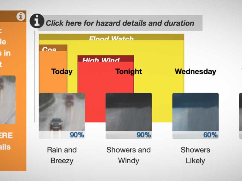
The National Weather Service issued a “Special Weather Statement” at 4:30pm Thursday (Nov. 12th), warning of a “vigorous cold front” hitting the area Friday morning, bringing rain, wind and snow to the mountains.
Could this be the first breath of ol’ man winter?
Here’s the statement:
… Active weather day expected Friday…
A vigorous cold front will pass southeast across western Washington Friday morning… bringing Rain… Mountain snows… locally windy conditions and possibly snow showers to parts of The Lowlands.
South winds in advance of the front will increase late tonight into early Friday morning… mainly along the coast and parts of the northwest interior including the Admiralty Inlet region. Wind speeds in those areas are expected to reach 20 to 30 mph with a few gusts to 45 mph… mainly in and around the Island County area. After the front passes… winds will become west to southwest down the Strait of Juan de Fuca and across the northwest interior before diminishing through the afternoon. While below Wind Advisory criteria… wind of this strength could blow down a few tree limbs here and there with isolated power outages.
Colder air will surge in behind the front and lower already low snow levels across the region. During the morning hours ahead of the front the snow level will be around 1500 to 2000 feet. The snow level will then gradually drop through the day to around 500 feet by evening. This means some of the highest hills around the region could see a few snow showers late Friday into Friday evening. However… outside of the mountains or the immediate Cascade foothills… little to no snow accumulation is expected.
Dry and tranquil weather will return to the region late Friday night into Saturday.
The National Weather Service issued a “Special Weather Statement” Tuesday Nov. 3rd at 4:57pm, warning of “very strong” winds and rain hitting the area Thursday (Nov. 5th) with gusts possibly as high as 50mph.
Here’s the warning in all its glory:
Statement as of 4:57 PM PST on November 03, 2009
… Windy conditions for the mountains… coast… and northern interior Thursday…
A strong Pacific frontal system will impact western Washington on Thursday. Breezy southeasterly winds on Wednesday night will become south-southwest on Thursday for the north interior and coast increasing to 20 to 30 mph with gust as high as 50 mph.
Winds just above the surface will be very strong on Thursday. Ridgetop winds for the Olympics and lower south facing slopes will range from 45 to 65 mph with higher gusts possible. Ridgetop winds along the southern slopes of the Cascades will also be windy… with sustained winds up to 50 mph possible. The strong winds will also be accompanied by heavy rains… combining for dangerous conditions in the mountains.
So…considered yourself warned, and batten down the blue tarps hatches B-Town.
The National Weather Service has issued a “Special Weather Statement” alerting us all that, despite the recent sunny weather, the rain is a-comin’ back, starting Tuesday (Oct. 13th), so be sure to take heed an move all that crap in your yard and driveway back inside.
Or pull out the blue tarps so Burien can look like it should!
Here’s the statement, which was published at 4:44pm Sunday Oct. 11th:
Statement as of 4:44 PM PDT on October 11, 2009
… A series of Pacific storms will affect western Washington this week…
Columbus day will be a transition day from the recent cool and dry spell to an active… wet pattern. Look for a series of Pacific storms to affect the area starting Tuesday. The Tuesday system is expected to bring windy conditions to the coast and Cascade foothills as well as precipitation to the entire area. Chilly…east winds in the Cascade passes will mean that the precipitation will begin as snow or a rain and snow mix. However… significant snowfall amounts are unlikely.
Unsettled… wet conditions will persist on Wednesday as the region remains under the influence of a large area of low pressure over
the eastern Pacific. A much wetter system may affect the area during the latter part of the week.Monitor forecasts from the National Weather Service in Seattle for updates on these upcoming events.
(Photo by Michael Brunk)
We haven’t seen one of these since July 29th, when the temps hit 104-degrees – an actual Weather Advisory – this time for quite the opposite: a cold/wet and “breezy” front to come in Saturday.
Consider yourselves warned, especially those of you planning on attending say, an outdoor wedding late Saturday afternoon:
… A cool and wet Labor Day weekend is expected across western Washington…
A cold front will move across western Washington on Saturday… bringing periods of rain… cooler… and breezy conditions. The front will be followed by an unseasonably cool and showery upper level trough Saturday night through Labor Day. Temperatures in The Lowlands Sunday and Labor Day will struggle to hit the lower 60s during the afternoon hours.
Snow levels in the mountains will be around 6000 feet Saturday night into Labor Day. Temperatures above 3500 feet will remain in
the 40s during the daytime hours. Cold temperatures will be accompanied by occasional showers and breezy conditions.People planning travel into the mountains this weekend should be prepared for fall-like conditions. Dress warm and take rain gear. Hypothermia can occur with these expected conditions.
Need further evidence to get your rain coat out? Local celeb Meteorologist Cliff Mass talks about this weather event on his blog here.
Photo courtesy Gregory Rehmke.

Underneath these dinghys and picnic table lies a physical, wooden dock that is usually above the waterline of Lake Burien, but Thursday is partially submerged due to the record rainfalls. Photo by Cynthia Reid.
According to the National Weather Service, a record amount of rainfall fell at Sea-Tac Airport on Wednesday, Jan. 7th – 2.29 inches!
This kicks the butt of the lame old record, which was a paltry 1.33 inches, set in 1996.
We’re going into a slight dry spell now, with just an 80% chance of rain Thursday, with more clearing on Friday.
However, the massive amounts of moisture that fell are now either overflowing rivers and streams, or overflowing the soil, and the danger for landslides is still high; here’s a list of signs to look for if you live in a known slide area (courtesy the USGS website)
- Springs, seeps, or saturated ground in areas that have not typically been wet before.
- New cracks or unusual bulges in the ground, street pavements or sidewalks.
- Soil moving away from foundations.
- Ancillary structures such as decks and patios tilting and/or moving relative to the main house.
- Tilting or cracking of concrete floors and foundations.
- Broken water lines and other underground utilities.
- Leaning telephone poles, trees, retaining walls or fences.
- Offset fence lines.
- Sunken or down-dropped road beds.
- Rapid increase in creek water levels, possibly accompanied by increased turbidity (soil content).
- Sudden decrease in creek water levels though rain is still falling or just recently stopped.
- Sticking doors and windows, and visible open spaces indicating jambs and frames out of plumb.
- A faint rumbling sound that increases in volume is noticeable as the landslide nears.
- Unusual sounds, such as trees cracking or boulders knocking together, might indicate moving debris.
Also, the Cedar River in Renton was above its “flood stage” at 15.8 feet Thursday morning; flood stage is 12.0 feet. A Flood Warning remains in effect for it until Saturday evening, and its expected that the Cedar will crest around 16.4 feet at Noon Friday, flooding areas of Renton, including the airport.

At 3:24pm Monday Jan. 5th, the National Weather Service issued the following Flood Watch Advisory:
… Flood Watch in effect from Tuesday evening through Friday afternoon…
Rain will fall over western Washington beginning Tuesday afternoon and continuing into Thursday. Rain will be heavy at times in the mountains… along the coast… and over the southwest interior and lower Chehalis valley. The Cascades and Olympics will get 5-10 inches with some southwest facing slopes 15-20 inches. Perhaps 6 inches will fall on the coast and SW interior. The Seattle area could see 4 inches over the two days and northern lowland areas will get an inch or two.
This sums to a real flood potential… both for river flooding and urban and small stream flooding. This flooding will be driven by heavy rain that has been consistently present in numerical models. Some flooding seems certain… and major flooding is possible on some rivers.
Precautionary/preparedness actions…
Monitor weather forecasts in case conditions change. If you live near a river… prepare for flooding now.
There are plenty of creeks and streams in the Burien area, so be sure to check for clear drains and clogs if you live or work near one.

Only patches of snow remain in the Burien area Saturday (some side roads may still be slushy), and proof that it is melting lies above in the sad crime scene photo of a one-time Snowman’s remains found on an area lawn.
But fear not B-Towners, for we all know that Frosty will return again.
The only question remains: how soon?
What we do know is:
- The rain will continue for the next several days with highs in the 40s.
- A Flood Watch is still in effect for small streams in King County; here’s the warning from the National Weather Service:
Rain locally heavy at times will persist through tonight. Rainfall amounts of a half to one inch with locally higher amounts on the coast are likely by Sunday morning. This combined with melting snow across The Lowlands or elevations below 2000 feet will likely result in some urban or small stream flooding. Residents in urban areas are strongly encouraged to clear any blockages of storms drains before it causes flooding problems.
Excessive runoff from rain and snow melt will cause ponding of water on highways… streets and underpasses… in urban areas with poor or overwhelmed drainage… and will also cause elevated levels on small creeks and streams.
Do not underestimate the power of flood waters. Only a few inches of rapidly flowing water can quickly carry away your vehicle.
Sure, there aren’t any major rivers running through the Burien area, but we do have some significant creeks (ie: Miller & Walker Creeks), so everyone should make sure to clear any storm drains near your home, and if you’re near any of the above-mentioned creeks, please check on them and make sure they’re flowing well.
Here’s the official Flood Watch warning:
… Flood Watch remains in effect through Sunday morning…
* a Pacific storm will bring warmer air and raise the snow level significantly. The combination of increasing southerly winds… milder temperatures… and rain on snow will result in rapid snow melt across The Lowlands tonight and Saturday. There is also the potential for minor flooding of the Skokomish River Saturday as the snow level climbs to near 5000 feet on the olympic range.
* The combination of rain and melting snow across The Lowlands could result in urban and small stream flooding… especially in those areas where a foot or more of snow was still on the ground. Snow and ice may result in clogging of storm drains that could result in flooding of streets and… possibly…homes and businesses.
* The Chehalis river and its tributaries could also approach or exceed flood stage. Up to two feet of snow covers the Chehalis watershed and it will all likely melt by Sunday. That water… along with the rain… will cause the rivers of southwest Washington to rise significantly.
Precautionary/preparedness actions…
A Flood Watch means conditions are favorable for flooding but flooding is not imminent or occurring. Monitor the latest forecasts from the National Weather Service and be ready to act quickly if flooding is observed or a warning is issued.
And remember – if you have any interesting weather-related photos to share, please either email us or add ‘em to our Flickr Group so we can share them!

Carolyn Rosenfield found an easier way to get around Burien – by cross country skiing on SW 172nd in 3 Tree Point. Photo by John Naubert.
10:45am 12/24/08 UPDATE: The soggy rain transition period continues, and with it comes potential new dangers like clogged storm drains, slushy roads, large walls of plowed, heavy snow and excessive roof loads.
Some updates:
- The City of Burien’s offices will be open until 2pm this afternoon.
- All Burien Parks and Recreation programs are canceled for the week.
- Far as we know, most restaurants in Burien are open today (including The Mark)
- Normandy Park residents have until 3:30pm to haul their own garbage/recycling to one of two locations for disposal (think of yourself as Santa; read this post here for details)
- Metro Transit is focusing on core service until weather and road conditions improve, which means bus service will be significantly limited during the weather emergency. Information about bus status is available on Metro’s Ice & Snow page, which is updated frequently. You can also call the Metro Customer Information Office at (206) 553-3000, but call volumes are high and there may be a wait to talk to a CIO representative.
- Burien’s garbage & recycling service has been canceled for today, Dec. 24 (Waste Management) http://www.wmnorthwest.com/weatherboard.html
- Residents are advised to avoid piling snow on top of storm drains when shoveling sidewalks and driveways. Storm drains need to be kept clear, so when the snow melts the runoff has some place to go. Residents are encouraged to clear snow from storm drains, when streets are clear of cars, after snow and ice starts to thaw. Clearing snow from storm drains will help to reduce the amount of localized flooding, which is likely to occur based on weather forecasts of warming temperatures and rain.
Here’s some info from the City of Burien’s website on excessive roof loads:
Recent weather conditions in the region resulting in abnormally heavy snowfalls may result in excessive roof loads on buildings due to the accumulation of snow and ice.
The series of snow storms that have hit the state have left several inches of snow and ice on roofs, which have added to the total weight that trusses and rafters must support. A cubic foot of snow can weigh from seven pounds for snow that is new and dry up to 30 pounds for old, compacted snow. Rain falling on accumulated snow will add even more weight. The combination of these factors and the recent forecast which calls for more snow and rain over the next couple of days may cause an excess of snow loading on many roofs.
Watch for Early Warning Signs of Overloading:
- Be on the watch for these warning signs:
- Severe roof leaks, indicating torn roof membranes.
- Ripples or bends in metal supports.
- Loud popping noises emanating from the building structure.
- Water ponds in areas where it never accumulated before.
- Obvious deformities in the roof.
What to do if you Suspect Overloading
When snow removal is necessary, it should be remembered that unsafe procedures may cause a collapse and injuries. Anyone working on a roof must have adequate fall protection and keep in mind that workers and others nearby can be injured by snow being dumped from a roof.Once it has been determined that the snow must be removed, there are several options for snow removal.
Most roofing contractors are equipped to handle snow removal from the roof of your home and buildings.
Another option is to remove the snow yourself. The best way to do this is to get up on your roof and push the snow off with a broom or shovel. It is important to use ladders, safety ropes and take necessary precautions.
Snow rakes also can be used to remove snow. When using a snow rake, use extreme caution when working near overhead electrical power lines. Also, avoid excessive scraping on the roof or trying to chip off any ice.
And finally, here’s a cool website where kids of all ages can watch Santa’s progress as he delivers his goodies around the world:
Lake Burien is still partially frozen Wednesday morning, with a fresh dusting of scenic snow. Photo by Gregory Rehmke.
Looks like we’re in the icky weather transition period where the snow turns into rain (depending on where you live – we’re near the water and it’s raining here), and the roads become a huge slushy mess – a perfect day to clear any and all storm drains near your house, as the next phase will involve lots of water.
There’s still a Winter Weather Advisory in effect until 4pm today:
The Winter Weather Advisory is now in effect until 4 PM PST this afternoon.
Snow is expected to continue this morning. By late morning or early afternoon the snow will change over to rain in locations below 500 to 1000 feet. The higher hills continue with snow through this afternoon.
Up to two inches of new snow is possible before the change over to rain. Higher amounts are possible on hills above 500 to 1000 feet.
Snow showers could bring additional accumulations late tonight and on Christmas day.
Precautionary/preparedness actions…
A Winter Weather Advisory for snow means that periods of snow will cause primarily travel difficulties. Be prepared for snow covered roads and limited visibilities… and use caution while driving.
Just when you thought the worst was over comes this brand spankin’ new Winter Weather Advisory (as of 4:58 12/18/08) from the National Weather Service – basically, another, even more powerful storm is coming this weekend, with snow, sleet and lots of wind:
… Major winter storm should impact western Washington from late Saturday afternoon through Sunday…
After the current round of snow showers is gone… the next weather system to impact western Washington will arrive on the coast on Saturday afternoon and spread inland on Saturday night. This system will contain a lot of moisture and should bring a wide variety of winter weather conditions to all of western Washington.
Perhaps the most significant impact will be potentially destructive winds in the Cascades and the east Puget Sound lowlands. See the high wind watch issued by this office.
This system will contain a lot of moisture as it spreads over the cold air mass in place. Precipitation should first start in the form of snow as it spreads inland. Heaviest snow amounts should take place along the central coast… in the lower Chehalis valley… over the Kitsap peninsula and the southwest interior.
Snowfall totals could exceed 6 inches for many locations with a few locations reaching a foot in a few places. Strong east winds could then cause blowing and drifting of snow.
Elsewhere… including the Seattle-Tacoma-Everett corridor… snow accumulations are expected but amounts will be less.
Later Saturday night and Sunday morning… a layer of warm air aloft will overspread sub-freezing air at the surface. This could cause snow to mix with or change to sleet and freezing rain… mainly south of a line from Ocean Shores to Everett. If more precipitation falls in the form of freezing rain as opposed to snow… then significant icing in excess of one-quarter inch would be possible in these areas. Ice accumulations of this magnitude can cause power lines to snap… bring down large tree branches… and cause widespread travel disruptions.
Temperatures on Sunday afternoon are forecast to rise a little above freezing for most of the western Washington lowlands… so the threat of freezing rain would end at that time.
This has the potential to be a significant winter storm for much of western Washington. Many of the exact details remain uncertain… so check back for the latest forecasts… watches and warnings as the details of this event become more solid.
Regardless of the details… be prepared for winter weather and significant weather-related disruptions this weekend starting Saturday afternoon.
Note how the forecast mentions “south of a line from Ocean Shores to Everett”?
Here’s a map of that line, and notice where Burien is located:

So…are you ready for this one?

The National Weather Service released this “Winter Storm Watch” warning at 2:10pm Thurs. Dec. 11th:
… Winter Storm Watch in effect from Friday afternoon through late Friday night…
The National Weather Service in Seattle has issued a Winter Storm Watch… which is in effect from Friday afternoon through late Friday night.
Heavy lowland snow is possible over portions of western Washington Friday night.
At this time it appears that the highest probability of accumulating snow in The Lowlands will over the Kitsap peninsula… along the Strait of Juan de Fuca… and in the foothills of the Cascades. Other areas such as the north coast… the areas north of Seattle in the Puget Sound convergence zone area… and at elevations above about 700 feet in the southwest interior… may also see heavy snow accumulations Friday night depending on the exact track and intensity of the incoming storm. Three to five inch accumulations are possible in the lowland watch area.
A majority of current forecast models suggest that snow would begin falling during the late afternoon hours over the Kitsap peninsula and around Hood Canal… then spread into other areas in the watch around the tail end of the evening commute.
Precautionary/preparedness actions…
A Winter Storm Watch means there is a potential for significant snow accumulations that may impact travel. Continue to monitor the latest forecasts.
Also note that Sunday’s forecast looks *very* cold, with a High of just 28°F and a Low of 19°F!
So…batten down the hatches and stock up B-Town! A storm’s a-brewin’!

According to King County officials, a very heavy rainstorm is en route to our area (due here ’round Thursday) and we here at the B-Town Blog have a common-sense suggestion that may take your mind off all those dang political thangs going on today:
In-between watching election results, why not go outside and clear out your nearest storm drain?
Here’s some info lifted directly from the King County website:
Heavy rainfall is forecast for later this week, which means King County residents should be prepared to deal with flooding and weather-related emergencies.
“Our crews are prepared for the first potentially serious storm of the season,” said Harold Taniguchi, director of the King County Department of Transportation. “And, as the storm season starts, our Road Services Division already has overnight crews out in the field on the watch for weather-related problems.”
Throughout the storm season, Road Division crews will try to stay one step ahead of the natural elements when it comes to dealing with rain, snow, ice and wind. But, county residents can also do their part.
“We really appreciate it when residents help us out with simple things like clearing leaves away from storm drains, not abandoning their cars or driving through floodwater, and calling us about problems in their unincorporated neighborhoods,” said Tony Ledbetter, maintenance superintendent for the Road Division.
Residents are also encouraged to report problems on roads in unincorporated King County by calling (206) 296-8100, or 1-800-KC ROADS if they live outside the greater Seattle calling area.

The patented, trademarked and copyrighted B-Town Blog Weather Rock®™© looks like its on the verge of needing a very absorbent diaper soon, as it’s just issued the following Weather Advisory:
… A powerful and wet Pacific storm will bring significant rainfall to western Washington tonight through Wednesday…
A powerful storm more typical of autumn will bring rain… locally heavy… to the area tonight through Wednesday. Storm total rainfall amounts are expected to be in the 2 to 4 inch range in the Olympics… and the 1 to 3 inch range on the coast and Cascades. Elsewhere… amounts will be less or generally in the quarter to one inch range. It is possible that the heavy rains could lead to water rises on small creeks as well as ponding of water in low lying areas.
In addition to the significant rainfall… this storm system will bring gusty winds and usher in a colder air mass Wednesday night. By early Thursday… the snow levels are expected to be mainly in the 6000 to 6500 foot range. People planning on hiking or camping in the mountains should be prepared for Fall-like weather and plan accordingly.
If you don’t have your own patented, trademarked and copyrighted Weather Rock®™©, you can get the full weather report here.
The rain will not dampen nor stop today’s Farmer’s Market.
Repeat: no matter what size raindrops are falling, the Farmer’s Market will open today at 11am on 10th Ave SW between SW 152nd and SW 151st.
It’s open until 6pm (but if you want the really good, fresh stuff, come on down *now* as most vendors are selling now).
Here are some of the things you can find at today’s Market:
√ Fresh – vegetables, seasonal fruits and berries
√ Fresh flowers – bouquets
√ Fresh, hungry worms perfect for composting
√ Plants – perennials, baskets, vegetable baskets
√ Breads – organic grains – baked fresh daily
√ Pies – fresh fruit pies (Mmmm…pie…)
√ Handcrafted – colorful pottery, yard art, jewelry, pictures, woodwork
√ Blogging – live, real blogging done from within the B-Town Blog booth
√ Hearty Northwesterners who don’t let a little rain stop them from moving onward with their lives
So let me get this straight – last weekend the temp hit 75 or so, and this coming weekend it may…gulp…SNOW???
Or at least freeze all the spring blooms?
What’s going on?
Is this some kind of Earth Day practical joke?
From the National Weather Service, updated 10:21 AM PDT April 16, 2008:
Unusually cold weather is expected Friday through early next week…
A deep upper level low pressure system moving southeast from the Gulf of Alaska will move into the area Friday and will linger through early next week. This upper level low will give quite cool and unstable conditions to the area Friday and Saturday. While drier air will begin to filter into the area Sunday into Monday… temperatures will remain unusually cool for mid to late April.
At this time of year… temperatures in The Lowlands typically range from lows 35 to 45… and highs are near 60. Low temperatures on Friday and Saturday will generally be in the 30s… while highs stay in the 40s. These temperatures are more typical of early to mid February. Near record low maximum and minimum temperatures are likely on Saturday. Temperatures in the mountains will stay in the 20s and 30s.
Snow levels Friday night and Saturday morning will average around 1000 feet… and may fall to near sea level in heavier showers. Any snow that falls in The Lowlands is unlikely to stick… except briefly on cars and grass. The mountains and Cascade passes will see accumulating snow Friday through Saturday… with accumulations over the two day period possibly between 1 and 2 feet.
Strong high pressure developing over British Columbia Saturday night into early next week will allow drier air to filter into the area. While daytime temperatures will moderate into the lower tomid 50s Sunday and Monday… nighttime lows will be quite cold for this time of year with any clearing. Frost… with freezing nighttime temperatures in protected and outlying areas will likely cause problems for anyone with sensitive Nursery stock…ornamentals…or vegetables that were planted early.
Monitor the forecasts from the National Weather Service closely the next few days.
Sadly, no snow fell (or at least stuck) in B-Town overnight, but according to the National Weather Service, we’re not out of the woods yet – another cold air mass is expected to come in Monday, with potential accumulations through Tuesday:
“A COLD AND UNSTABLE AIR MASS OVER THE REGION WILL ALLOW FOR SCATTERED SNOW SHOWERS OVER WESTERN WASHINGTON THROUGH MONDAY. SOME LOCAL ACCUMULATIONS ARE POSSIBLE AT ANY TIME THROUGH MONDAY. ANOTHER COLD WEATHER SYSTEM WILL AFFECT THE REGION LATE MONDAY NIGHT INTO TUESDAY. THIS SYSTEM MAY BRING SIGNIFICANT SNOWFALL TO THE LOWLANDS BEFORE THE PRECIPITATION CHANGES OVER TO RAIN. COOL AND UNSETTLED WEATHER IS EXPECTED THE REST OF THE UPCOMING WORK WEEK. NOW FOR MONDAY NIGHT INTO TUESDAY…HMMMMM…LOOKS INTERESTING. AIR MASS IN PLACE OVER THE REGION IS FAIRLY COLD WITH LOW THICKNESS VALUES AS A STARTING POINT. MODELS HAVE BEEN RATHER CONSISTENT IN BRINGING A FAIRLY STRONG SYSTEM ONSHORE EARLY TUESDAY…THE PROBLEM IS WHERE THE CENTER OF THE SYSTEM MOVES INLAND. CURRENT MODEL RUNS HAVE A LOW CENTER MOVING RIGHT DOWN THE STRAIT ON THE NORTH END AND RIGHT DOWN THE COLUMBIA ON THE SOUTH END WITH ANOTHER MODEL SPLITTING THE DIFFERENCE. ALL OF THEM MAKE FOR INTERESTING WEATHER. THE DIFFERENCE WILL BE WHEN AND IF THE PRECIPITATION CHANGES FROM SNOW TO RAIN.”
So…keep your mitten-covered fingers crossed…we may have a Snow Day soon!
Video taken at Eagle Landing Park on 12/3/07.
According to the submitter:
The storm drain is running about half as fast in this video, as it was during the heaviest rains. Over 4.5 inches of rain in a 24 hour period.


