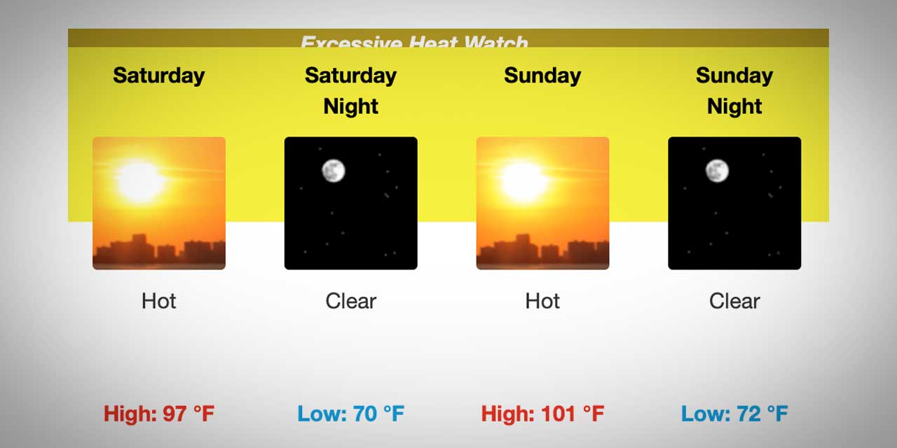
Looks like the hottest heat from “Hotpocalypse ‘09″ is over, so now it’s time to do what every media outlet does – let’s take a nostalgic look back at this heat wave that just happened, where temps ranged from a high of 103 (our unofficial Burien high was 104) on Wednesday to 96 Thursday.

Here’s a photo slideshow of the record-setting days as shot by Photographer Michael Brunk:

Click to View Michael Brunk’s Photo Slideshow

We’re not saying that the 102.9-degree heat recorded Wednesday, July 29, 2009 was the hottest day ever.

No, that would be pretentious of us to think that it’s never been warmer here (since 1891 is when records started being kept, and there was plenty of weather history before then, right?).

With that said, can you FLIPPIN” BELIEVE HOW FLIPPIN’ HOT IT WAS TODAY???

104 degrees?

IN BURIEN???

Okay, so now that it’s cooled down a bit (and our keyboard isn’t drenched in sweat), we’d like to share some pics that BTB Readers sent us after we asked for “hot temp” pics (sorry, we’re only sharing the G-Rated stuff…and thanks gang, keep sending us more of those special pics!):

From Reader Carrie Rasmussen comes these photos of cookies being cooked in the back window of her Nanny Gloria’s car:

That's right...those are chocolate chip cookies baking in the rear window of a car.

And here they are...chocolate chip cookies. Freshly baked. In a CAR.

From Reader Candice Packer comes this pic of a truly-retro Honeywell thermostat showing that today’s temp was totally off the chart:

Our own Mini Cooper Blogmobile recorded the following 104-degree temp whilst overheating in downtown Burien:

BTB Photographer Francis Zera appears to have won the “hottest place” contest with this shot of his thermometer hitting 106.2!:

Francis’ prize of course is a duct-taped-patched down snowcoat we found at Value Village for $4.99, which he will be required to wear everyday (zipped up to the neck) until summer ends.

In the meantime, if you have any hot weather pics (wink wink), send ‘em our way. We’ll be posting more until we pass out from heat exhaustion.

The patented B-Town Blog Weather Rock™® (ok, so it’s not really a rock but we bet there’s quartz inside there, plus, that sounds waay cooler than a “Digital Thermometer”) shows proof that yes, the outside temp has hit 100 degrees in Burien, specifically outside our office window in Olde Burien.

Hey…remember during the big snowstorm last December, when everyone sent pics of how much snow they had in their yards?

Let’s do that again, only this time please send pics of the temp on your Weather Rock (aka “digital thermometer”; heck, we’ll even post analog ones) to us and let’s see who’s got the hottest yard!

Email us here.

Now, enjoy this photo and remember this record-setting day/week; and do you think it’s going to get much hotter?:

by Dr. Leslie Kasper, DVM
Companion Animal Medical Center

Boy it’s hot out! Ninety-plus degree weather and no real rainfall in months; Burienites haven’t seen weather like this for some time! But I guess now they understand the real meaning of “The Dog Days of Summer.”

I mean really, you think you got it bad?! Don’t forget about us – imagine wearing a fur coat and not being able to sweat other than through the pads of your feet (unless they are hairy too) and by panting! Yuck, Dry Mouth! So just as a kindly reminder from some of your fuzzy four-legged friends, here are some tips to help make keep us cool and comfortable too!

Cars + Pets = Death!
Think I’m being dramatic? Hundreds of pets die every year from being left in cars during summer heat. Yes, I know it’s just a quick errand and you left the windows cracked or even down, but in 80+ degree heat outside, the inside of a car can easily reach over 100 degrees in about five minutes. Best course of action is to just leave me at home! Really, you will only be gone a few minutes…

Shade or Shelter
If some of your four-legged friends spend a majority of their time outside during the day, make sure they have an adequate amount of shade to protect themselves. Doghouses can be helpful, but like your house or car, if it’s in the sun all day they can hold heat and provide little comfort. If the roof is detachable try lifting it up slightly or setting it off kilter to allow for airflow and heat escape. Having a second shelter or shaded area allows for options as the day and temperatures progress. If your pet has a light skin colored nose or ears (areas with little to no hair) a bit of sunscreen may be warranted as well.

Fresh water at all times!
Inside or out, all pets need access to fresh clean water. If possible when outside keep it in the shade, then it is bearable to drink and doesn’t evaporate quite as fast. Multiple bowls may be needed as we will go through more water than usual. But even inside, with all the fans and a/c going, the air becomes dry, and a good drink would feel great on that panting tongue. And ice cubes make fun toys!

Oh, and on the subject of mouths…
Don’t be surprised if the appetite falls off a bit! Sometimes it just doesn’t sound appealing to eat in this heat. Oh, and of course, sometimes heat can cause imbalances in the intestines, so soft stools can occur also!

Emergency Situations
Okay, we all know you are great pet-parents, but sometimes it’s just too hot! If you notice any of these symptoms, please call my veterinarian right away for evaluation or advice:

  • Difficulty breathing, especially in cats or dogs with short noses (like pugs, pekes, bull dogs, and others)
  • Pale gums, nose, eyes, or inner ears which are normally pink.
  • Vomiting, diarrhea, or lack of food/water intake
  • Shaking, seizures, or unresponsiveness when stimulated.

Okay, now go out and be safe!

Sincerely,
Rover and Tiger

(Courtesy of BTB Advertiser Companion Animal Medical Center, 206-878-0405)

The National Weather Service has released an “Excessive Heat Warning” along with an “Air Stagnation Advisory,” and while it may not be hot enough to cook an egg on the sidewalk (but if you do, email us a pic!), predictions are that the temps Wednesday and Thursday will hover around 100+, so be sure to stay cool, drink plenty of fluids and all the other common sense things one should do when it’s really hot.

Here’s the warning/advisory from the bigshot professional weatherpeeps:

Excessive Heat Warning, Air Stagnation Advisory
Statement as of 4:30 AM PDT on July 29, 2009

… Excessive heat warning remains in effect until 6 PM PDT Friday…
… Air stagnation advisory remains in effect until 6 PM PDT Friday…

An excessive heat warning remains in effect until 6 PM PDT Friday. An air stagnation advisory remains in effect until 6 PM PDT Friday.

Hot and humid conditions are expected to continue through Thursday. High temperatures from the upper 80s to 105 will be accompanied by rather humid conditions and only light breezes. Temperatures at night will remain quite warm… falling only into the 60s for a couple hours late at night in most places.

Record high temperatures will be widespread… and SeaTac Airport will likely tie or break its all time record high temperature of 100 degrees. While today is expected to be the hottest day overall… Thursday will be only a degree or two cooler in most locations.

Friday will be somewhat cooler as the low level flow turns onshore … but temperatures in the western Washington interior will still be well above normal with many spots in the upper 80s to mid 90s.

In addition… the stable air mass will limit dispersion of ozone pollutants and air quality will deteriorate.

Precautionary/preparedness actions…

An excessive heat warning means that a prolonged period of dangerously hot temperatures will occur. The combination of hot temperatures and high humidity will combine to create a dangerous situation in which heat illnesses are likely. Drink plenty of fluids… stay in an air-conditioned room… stay out of the sun…and check up on relatives and neighbors.

If you are concerned about the buildup of pollutants… check with your local air quality agency for further information.

If you need ideas on how to stay cool during this weather, here’s some previous stories we’ve posted:

And if you need a visual to focus on as you meditate your way to coolness, here ya go:


The Burien Parks Department wants kids of all ages to cool down by running through their sprinklers at Lake Burien School Park, where they’re turning on the irrigation systems for two one-hour periods over the next few days.

If you’re wondering what this new “spray ground” looks like, here’s a video courtesy Michael Lafreniere, Director of Burien Parks:

YouTube Preview Image

Here are the details:

WHAT: Lake Burien School Park’s main grassy area will become a “spray ground” as the Department turns on the irrigation systems for two 1-hour periods over the next few days.

WHEN: Tuesday, Wednesday and Thursday (7/28/09-7/30/09), from 3pm-4pm and again from 7pm-8pm

WHERE: Lake Burien School Park (located at SW 149th & 16th Ave SW)

COST: None. It’s FREE!

INFO: The Parks folks also add:

“In addition to this fun and wet opportunity to cool off, some cool breezes can be found along the shore at Seahurst Park, in the cool forests of Eagle Landing Park and Dottie Harper Park, and along the really cool trails in Shorewood Park.

More information about these cool parks is at http://www.burienwa.gov/index.aspx?NID=687.”

Somewhere, somebody cranked the master thermostat waaaay the flip up, with temps in the 80s Monday and predicted to hit a major, possible record-breaking high between 99 and 106(!) on Wednesday.

While the city of Burien doesn’t have an official “cooling center” (hey city, what gives?) there are numerous places around with air conditioning that you can take advantage of; here’s a list (more listed at the King County website):

BURIEN:

  • King County Library branch on SW 152nd and 4th SW (as well as any KCLS branch in the area)
  • Any bar/restaurant/coffee shop that doesn’t have its windows open (your first clue to A/C use)
  • Stores – stay cool by going from store to store around town!
  • The myriad of beaches around town, especially Seahurst Park Beach

DES MOINES:

  • City Cooling Shelter at the Activity Center (Senior Center)
    2045 S. 216th Street
    Des Moines
    Open for Des Moines and Normandy Park residents, Monday-Thursday this week from 11:00am to 9:00pm. The shelter accommodations are minimal, water will be provided at the shelters but no food will be available. Small pets in carriers will be allowed but the owner is responsible to provide food, water and bowls for the animals.  Pets will be required to remain in their carriers will inside the shelter. An information phone number with recorded information has been set up at (206) 870-6719.

TUKWILA:

  • Tukwila Community Center
    12424 42nd Avenue South
    6:15am. – 9pm (Monday – Thursday)
    Phone: 206-768-2822
  • Tukwila Aquatic Playground
    12424 42nd Ave South
    Tukwila, WA 98168
    Website: http://www.ci.tukwila.wa.us/recreation/recbrochure.html
  • Southcenter, where “it’s always a beautiful day” (and a cool one this week)
  • Tukwila Pond (go ahead and jump in, it’s not just a swamp…)

SEATAC:

  • SeaTac Community Center
    13735 24th Avenue South
    SeaTac, Washington 98168
    Phone: 206.973.4680

FEDERAL WAY:

  • Federal Way Community Center
    876 S. 333rd Street
    5:30 a.m. – 9:30 p.m. (weekdays)
    7:00 a.m. – 6:00 p.m. (Saturday)
    10:00 a.m. – 6:00 p.m. (Sunday)
    Phone: 253-832-6900
  • Wild Waves Water Park (cost involved)
    36201 Enchanted Pkwy
    Federal Way
    Phone: (253) 925-8000

AUBURN:

  • Auburn Senior Center
    808 9th Street SE
    8 a.m. to 9 p.m., Monday to Thursday
    Crated/caged pets welcome.Some pet cages available for those who don’t have them.
    Phone: 253-931-3016
  • Auburn Library
    1102 Auburn Way S
    10:00 a.m. – 9:00 p.m. (Monday – Thursday)
    Phone: 253-931-3018
  • Auburn City Hall
    25 W Main
    8 a.m. to 9 p.m., Monday to Thursday
    Crated/caged pets welcome. Some pet cages available for those who don’t have them.
    Phone: (253) 931-3033

For all you weather nerds out there, here’s a link to a new UW website called “probcast.com” that will do customized forecasts based on zip codes; here’a a screenshot of what we can expect for 98166 – note Wed.’s predicted high of 101!:

An Excessive Heat Warning will remain in effect until 6pm Thursday, July 30th; this means that a period of dangerously hot temperatures is expected which can lead to heat related illnesses. Anyone can be overcome by extreme heat, but some people are at higher risk than others. They include the elderly, the very young, and people with mental illness and chronic diseases

Signs and symptoms of heat related illness may vary but can include:

  • heavy sweating
  • paleness
  • muscle cramps
  • tiredness
  • weakness
  • dizziness
  • headache
  • nausea or vomiting
  • fainting

Heat exhaustion can lead to heat stroke, which can cause death or permanent disability unless treated immediately. Symptoms of heat stroke include an extremely high body temperature (above 103°F); red, hot, and dry skin; rapid, strong pulse; nausea, confusion and unconsciousness.

Public Health – Seattle & King County is urging people to take precautions and monitor themselves and others for signs and symptoms of heat related illness and call for medical aid as necessary.

Be sure to drink plenty of fluids and stay in air-conditioned buildings such as public libraries and community centers, malls and movie theaters. Check on relatives and neighbors, particularly those with health issues. Never leave children or pets unattended in a vehicle, even with the windows rolled down.

More hot weather safety tips are available at www.kingcounty.gov/health/BeatTheHeat

BTB Reader Philip Kelley sent us the pic below, and says:

“Of course, one way to beat the heat is with an ice cream cone.

I think I saw these two headed off toward Three Tree Point afterwards, probably to munch on a Mini Cooper…”

The National Weather Service issued a “Special Weather Statement” late Thursday afternoon (July 23rd) warning about a heat wave that will begin this weekend and last into next week, with projected highs in the 85-95 degree range.

Here’s the official warning:

… Hot weather beginning this weekend and lasting into next week…

The hottest weather of the year is likely to occur this weekend and early next week. High temperatures will be in the 85 to 95 range. Overnight lows will be in the 60s. All areas of western Washington could be affected.

The first really hot day will be Saturday or Sunday. The hottest days look like Sunday through Tuesday. At this time models predict the hot weather could last into Thursday or beyond.

Unlike many previous hot spells… this one could also affect the coast and other places near the water. Also it is rare to have many hot days in a row in western Washington… but this heat wave could last several days.

Western Washington is having a dry Summer… and no rain is in the forecast for the next week or so. Fire danger will increase during the hot weather. There is also a risk of air stagnation during this period.

The National Weather Service will issue more statements about this event over the coming days.

And according to meteorologist Cliff Mass:

“I took a look at the long-range forecasts and was shocked.

The temperature climbs through the weekend…into the lower 90s on Sunday and mid 90s at least on Monday and Tuesday.

Too far out to be sure now….but be ready for real heat.”

BTW, Cliff also adds that:

“2009 is the driest 20 May-19 Jul period on record using the combined SeaTac/downtown observations”

So…have a great weekend, but stay cool, slathered up, and be sure to check in on elderly neighbors/relatives and drink plenty of water!

The patented B-Town Blog Weather Rock® is already showing serious signs of melting due to the recent heat wave that’s come in,  so please be aware of the dangers of the following throughout the hot weekend ahead (yay.):

  • Pets in cars
  • Elderly neighbors or family members
  • Magical, large boulders used to predict weather

From the National Weather Service comes this “Advisory”:

…Hot weather across western Washington into the weekend…

A strong ridge of high pressure will build over the Pacific northwest today and persist through at least Saturday. Temperatures on Thursday will be noticeably warmer across western Washington under sunny skies. Offshore flow will strengthen on Friday with much hotter temperatures expected through Saturday.

Some spots may exceed the record high temperatures over the next few days.

Temperatures Thursday are expected to range from the upper 70s and 80s at the coast with widespread 80s across the interior. On Friday and Saturday interior areas north of Seattle will continue in the 80s with temperatures rising mainly into the low and mid 90s around the Puget Sound region… foothills…and southwest interior.

A switch to onshore flow will first occur Saturday afternoon along the coast resulting in cooler high temperatures. Temperatures will begin to moderate across the interior on Sunday as onshore flow increases.

Be careful of the heat in the coming days and check up on the elderly. Stay hydrated and avoid vigorous activity during the heat of the day. Never leave pets in a parked car.

The record temps to beat at SeaTac Airport are (go mercury!):

  • THURS. 8/14: 88 (set in 2005)
  • FRI. 8/15: 92 (set in 1967)
  • SAT. 8/16: 98 (set in 1967) 

So…enjoy another fine summer weekend, but be careful out there.

…and we have proof in this photo of our patented B-Town Blog Digital Weather Thingy®, taken at 2:34pm today in Three Tree Point, where it was probably a bit cooler than other ‘hoods:

The high at SeaTac Airport today was 90 degrees, and yes, we’re very proud that it was .3 degrees warmer at our place.

We hope everyone enjoyed this brief taste of summer.  Tomorrow should be considerably cooler.

We now return you to your regularly-scheduled Spring…

7pm UPDATE: According to the loco meteorologists, apparently the record high of 84 degrees was actually tied today at SeaTac Airport!

WAY TO GO YOU VISUALIZING B-TOWN BLOG READERS!

PREVIOUSLY: According to the patented B-Town Blog Weather Rock®, today’s high temps should be in the 80s.

To break the all-time record, today’s high would have to reach 85, and tomorrow 86.

We know that we can do it!

But the weather gods may need a little help, and that’s why we’re asking all B-Town Blog readers to take a minute, close your eyes, take three slow deep breaths, then, as you exhale the last breath, at the nadir moment where you’re neither inhaling or exhaling, turn your eyes upward and visualize the following:

  • Large bold newspaper headlines that shout: “High Temps Break All-Time Record!”
  • Wacky “on the scene” TV Reporters in colorful shirts and shorts doing over-excited live broadcasts from area beaches
  • The number 85 for today (repeatedly chant “85…85…85…”) and 86 for tomorrow (lather, rinse, repeat)

On another note, please use common sense this weekend, as when that bright orb comes out it’s easy to forget a few obvious “D’oh!” things, like:

  • Although you may get the urge to jump into area lakes, rivers or Puget Sound waters to cool off, it would not be a wise idea. Water temperatures are still quite cold, often in the 30s and 40s. Cold water tends to do bad things to the human body rather quickly…like this little thing called hypothermia, which causes muscles to cramp up from the cold.
  • Also, rivers are running high and swift due to Spring snow melt. Avoid jumping into swift moving, cold water.
  • Drink plenty of water and avoid overexertion.
  • Limit time spent in direct sunlight. Wear a hat. Slather the SPF on children (and yourself).
  • Check up on elderly relatives or neighbors.
  • Protect pets from the dangers of hot weather. Never leave them in a parked car on a hot day!
  • For those planning on taking advantage of the weather by hiking in the mountains, please be aware that there is an avalanche warning in effect for the Olympics and Cascades through Saturday.
  • For more details, visit the northwest weather and avalanche center web site at www.Nwac.US.

Now, get ready to do your visualization exercises and let’s see what we can do!