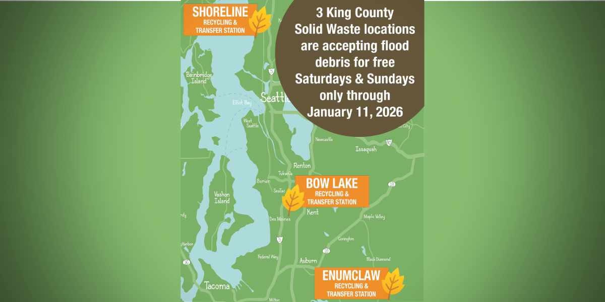
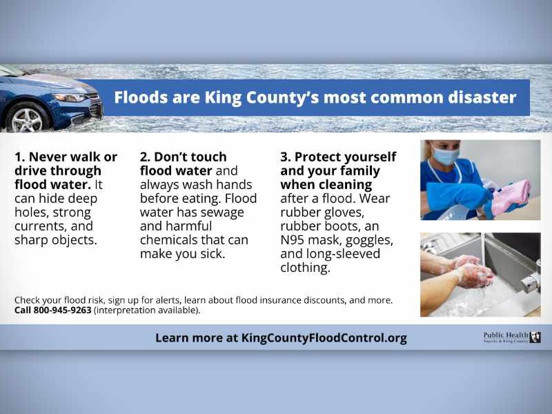
The National Weather Service issued an unusual Advisory Monday (Jan. 18th) – this one for a “minor tidal overflow” that will be in effect for Puget Sound Tuesday morning and possibly again Wednesday morning.

According to the report, “very high astronomical tides combined with lower than normal atmospheric pressures” as well as high winds may cause some flooding.

So, if you live near the shoreline and your street/yard/area has a tendency to flood, you might want to put out some sandbags just in case.

Here’s the actual advisory:

… Coastal Flood Advisory for minor tidal overflow is in effect for Puget Sound and the north interior from 5 am to 11 am PST Tuesday…

The National Weather Service in Seattle has issued a coastal Flood Advisory for minor tidal overflow from Puget Sound to the north interior… which is in effect from 5 am to 11 am PST Tuesday.

Minor tidal overflow may occur along some of the shorelines and nearby low-lying areas around Puget Sound and the north interior Tuesday morning… around the time of high tide. Minor tidal overflow is caused by very high astronomical tides combined with lower than normal atmospheric pressures. The Table below shows time of high tide for areas around Puget Sound… along with the normal tide table value and the expected total tide.

Time of tide table expected expected location high tide value anomaly total tide

  • Seattle 7:30 am 12.2 ft 1.6 ft 13.8 ft
  • Port Townsend 7:06 am 9.1 ft 1.8 ft 10.9 ft
  • Bellingham 8:12 am 9.6 ft 1.9 ft 11.5 ft

Minor tidal overflow problems usually begin at 13.5 feet around Seattle and 11.5 feet around Bellingham… and the current forecasts for those areas just meet or exceed those levels. In addition… the atmospheric pressure could be a little lower than forecast… and local winds may cause water to pile up along shorelines more than expected… possibly higher than the expected total tide values. Southeast winds 20 to 30 knots are forecast over the northern inland waters Tuesday morning as another deep low pressure system moves northward offshore. Winds over the waters of Puget Sound are expected to be south 10 to 20 knots Tuesday morning.

Another very high astronomical tide will occur Wednesday morning. The forecast tides for Wednesday morning are slightly lower than for Tuesday… but computer model forecasts indicate the anomaly will still be large enough so that minor tidal overflow problems remain a possibility.

Precautionary/preparedness actions…

Minor tidal over flow can cause local flooding along shorelines and nearby low-lying areas.

Sad news today from King County Miller/Walker Creek Basin Steward Dennis Clark – remember the two beavers who made their home (and subsequent dam) in a pond near Des Moines Memorial Drive in Burien?

They were euthanized last week.

Previously, we asked Readers what the city should do in regards to the creatures, and the results were:

  • 65% voted “Leave them alone, and just deal with the consequences”
  • 33% said “Re-locate them safely in the wild somewhere else
  • 2% said “Just kill the dam things before they flood downtown!”

So much for our new campaign to hire a “Beaver Whisperer” to psychically tell them to leave. Oh well.

Here’s an email we received from Dennis on Wednesday (Oct. 21st):

Scott,

I’m sorry to report that last week the beavers were euthanized.

We relied on the expertise of the wildlife biologists at the US Department of Agriculture-Wildlife Services Branch to make a determination about whether to relocate or euthanize the animals.  Their staff were very concerned about the transmission of disease (both from our animals to other animals and vice versa) and I suspect that was what led to euthanizing the beavers.  Their trained staff carried out the removal on behalf of the City.

One of Burien's two beavers that was euthanized last week.

As I mentioned to you before, the key problem was that keeping the beavers would raise the average water level in the wetland as they built up their dams and/or blocked the culverts under Des Moines Memorial Drive.  Beaver behavior (not unlike that of the other dam-builders, we humans) is to expand their territory.  If they were allowed to do this, there would be little room for the wetland to hold more water before it began to flood the septic drain field and driveways of one or more neighbors.  An even higher water level would threaten both homes and the integrity of Des Moines Memorial Drive itself.

This last Saturday, October 17, provided a dramatic example of how the wetland responds to rain.  From 8 a.m. to Noon — a mere four hour period — I observed the wetland water level increase by over one foot! Because the beavers had been removed and the water level lowered the previous day, the wetland was able to handle this rise in the water level, which still came just to the level of the nearest neighbor’s driveway.

Fluctuation of the level of the wetland IS a good thing because that is a sign that the wetland is storing water during storms.  If the wetland didn’t exist (and the City should be recognized for conserving it through purchase back in 2005) or if there were larger culverts under Des Moines Memorial Drive, the water would otherwise rush downstream, potentially flooding private and public property in Burien and Normandy Park and damaging stream ecology with higher flows (scouring spawning gravel, causing erosion, blowing fish and leaf debris downstream).

I was excited when the beavers showed up this spring because the healthiest streams do include beaver in their ecosystems.  I researched whether there were techniques we could apply that would allow us to keep the beavers as neighbors without flooding the human neighbors or undermining Des Moines Memorial Drive.  I observed their interaction with the wetland and talked with the neighbors to learn from them.

And I had hours to think on all of this while chest-deep in water each time I cleared out the culverts the beavers had blocked!  By the end of the summer, both I and City staff reluctantly concluded that there was not room for beavers in this urbanized stream.

It was a sad outcome for me personally because I came to respect the energy and dam-building skill of these remarkable rodents in addition to appreciating their ecological value.  However, I was also reminded each time I had to unplug the culverts or adjust the height of their dams that there’s a reasons we term beavers WILDLIFE.  They have their own needs and aren’t amenable to being “managed.”  Unfortunately, we could not accommodate their needs in this situation.

- Dennis

So…what do YOU think of the fact that these two dams beavers are now sleepin’ wit’ da fishes?

Please take our poll below, and/or leave a Comment…

Do you think that Burien's two beavers should've been euthanized?

View Results

Loading ... Loading ...

We’ve covered this before, but since then our friend Dennis Clark sent us these photos so we just had to do an update – Burien has its own, functioning, dam (building) beaver family living in Walker Creek near Des Moines Memorial Drive; the city may have to relocate these animals soon:

This is the beaver's dam home. The yardstick is used (by humans) to monitor water levels, which are affected by the beaver's dam.

This is a beaver in its home. Any dam questions?

A recent posting in our forums from Sue (one of the beaver’s neighbors) is worth a note as well, expressing her concern for the safety of the animals if they’re relocated:

“We have recently had a couple of beavers decide to move into our pond area off of Desmoines Memorial Drive.

But, because they’re affecting the culverts under the roadway, the city may relocate them to avoid having to pay to keep them in their protected habitat.

We’ve had a guy from King County out a couple of times, and they’ve lowered the levels of the dams and cleared out the culverts.

They have warned us that if the beavers keep being beavers, that they will have to be relocated.

I’m not sure if anyone knows this but the mortality rate of a beaver, once relocated, is very slim. Please help us keep our wild life!!

According to King County’s Miller/Walker Creek Basin Steward Dennis Clark:

As for the beavers, they are still there doing their dam beaver thing. I now TRULY understand the term “busy as a beaver.”

I’m the “King County guy” that Sue refers to, of course. Her characterization of the issue isn’t entirely accurate, unfortunately.

Right now, the City of Burien is reviewing how to manage the beavers. While it’s exciting to have the beavers and they provide ecological benefits, they also in their dam way cause some big drainage problems. The key challenge is keeping the culverts under Des Moines Memorial Drive free-flowing so water doesn’t back up and flood over the road and the neighbors to the north.

What makes the decision for the City particularly hard is that the costs of different options vary considerably and the outcomes of the more costly options are uncertain. WILDlife is unpredictable in its response to our efforts to “manage” it.

At this point, I don’t know when the City will make its decision.

previously, Clark has also written on his blog:

Per yesterday’s entry, further work was needed to clear the Walker Creek culverts under Des Moines Memorial Drive in Burien. Overnight, the beavers were as busy as — well, beavers — and they had partly replugged one culvert and rebuilt a dam.

My clearing efforts did raise the water level flowing downstream by 2 p.m. Friday. As occurred yesterday, shortly after I concluded my work, the water flowing downstream became clear. Any longer-lasting turbidity downstream likely is due to sediment in the stream being mobilized by the temporarily higher flows. Reports from people in Normandy Park confirm that turbidity decreases once the flows do.

This clearing of the culverts and the attendant flow fluctuations downstream hopefully should occur no longer than for a few days next week. This manipulation of the stream is not desirable and is only occurring as a byproduct of efforts to protect public property (a major road) and private property (a septic drain field).

So…what do YOU think the city should do with these beavers? Please take our poll, or leave a Comment below…

What should the city of Burien do with its beavers?

View Results

Loading ... Loading ...

The flooding Carbon River in Orting last week.

by Josh Hart

With all the flooding recently I wanted to find someone to talk to about what happened to them. I realized that someone very close to me had been affected, my great grandma and grandpa (Betty and Glen).

When I talked to them about the flooding this is what I found out:

Last Wednesday afternoon (Jan. 7th), they started to get phone calls from Pierce County Emergency Management saying that they should move to a higher location for the night. When Glen went to the store he saw that the water was getting pretty high on the roads. They debated leaving; they hadn’t had any flooding in their housing area yet.

They finally decided they were in danger when two fire trucks drove through the area with sirens on and announcing to everyone to “evacuate immediately” over their loudspeakers.

The Orting street where my great-grandparents live looks like it could easily turn into a river.

Their housing area is in Orting, between the Puyallup River and the Carbon River. Both rivers were over their banks and were starting to flood the roads. Many of the stores were closing so they decided they would leave the area.

They were worried and didn’t know what to expect. They didn’t know what belongings they should take with them or how long they would have to be out of the area. They had many people offer them a place to stay but didn’t know where the best place to stay was. Many of them were too far to drive to at the time, because traffic was so bad.

That night they stayed at a motel in Sumner and listened to the flood news on TV. The next morning it seemed like it would be safe to go home. So at about 9am in the morning they headed back to their housing area in Orting. It took them longer than usual, because the traffic was bad again.

However beautiful Orting is, it can still be very dangerous, not because of the two rivers, but because it lies in the shadow of Mt. Rainier.

While they were driving home they saw some places that were underwater. As they crossed the Carbon River, the water was coming right up to the banks. Despite the dangerous conditions, they got home safely and found that there was no damage to their yard or their house. It seems like their housing area hadn’t been affected at all.

They were thankful everything was safe and they were happy to be home with all their belongings and things they cherish safe and unharmed. 
And I am happy that my great-grandparents were spared and harm or damage.

However beautiful Orting is, it can still be very dangerous, not because of the two rivers, but because it lies in the shadow of Mt. Rainier.


View Larger Map

[EDITOR'S NOTE: Josh Hart is the B-Town Blog's first Intern! He's also a 15-year old student at Highline's “Big Picture High School” in SeaTac.

You can read more of his writing here...]

According to the City of Burien’s website:

FEMA has accepted the City’s Puget Sound Flood Hazard Study. The agency is scheduled to formally approve the study in January 2009. Until that time, the study and its flood hazard designations will be used by the City of Burien only for purposes of compliance with City codes and ordinances. Once FEMA has approved the study, it also will be used for flood insurance purposes.Due to their size, the appendices are not available on the website. You can view the appendices or request a CD of the full report at:

Burien City Hall
15811 Ambaum Blvd. SW, Suite C
Burien, WA 98166
Ph: (206) 248-5510

For more information about the study, contact the Department of Community Development at (206) 248-5510.

Read Burien’s Puget Sound Flood Hazard Study here.

Also, what are your thoughts on the study?

Please email us or post a Comment below.