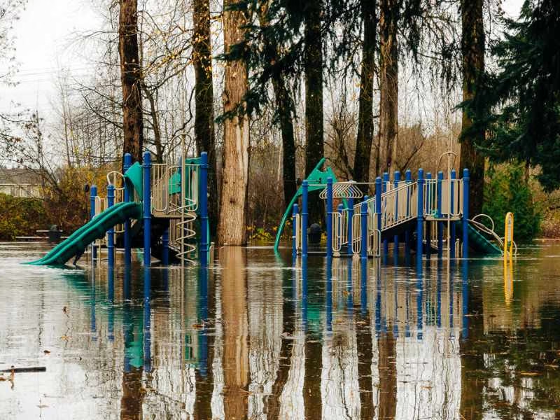
The National Weather Service issued an unusual Advisory Monday (Jan. 18th) – this one for a “minor tidal overflow” that will be in effect for Puget Sound Tuesday morning and possibly again Wednesday morning.
According to the report, “very high astronomical tides combined with lower than normal atmospheric pressures” as well as high winds may cause some flooding.
So, if you live near the shoreline and your street/yard/area has a tendency to flood, you might want to put out some sandbags just in case.
Here’s the actual advisory:
… Coastal Flood Advisory for minor tidal overflow is in effect for Puget Sound and the north interior from 5 am to 11 am PST Tuesday…
The National Weather Service in Seattle has issued a coastal Flood Advisory for minor tidal overflow from Puget Sound to the north interior… which is in effect from 5 am to 11 am PST Tuesday.
Minor tidal overflow may occur along some of the shorelines and nearby low-lying areas around Puget Sound and the north interior Tuesday morning… around the time of high tide. Minor tidal overflow is caused by very high astronomical tides combined with lower than normal atmospheric pressures. The Table below shows time of high tide for areas around Puget Sound… along with the normal tide table value and the expected total tide.
Time of tide table expected expected location high tide value anomaly total tide
- Seattle 7:30 am 12.2 ft 1.6 ft 13.8 ft
- Port Townsend 7:06 am 9.1 ft 1.8 ft 10.9 ft
- Bellingham 8:12 am 9.6 ft 1.9 ft 11.5 ft
Minor tidal overflow problems usually begin at 13.5 feet around Seattle and 11.5 feet around Bellingham… and the current forecasts for those areas just meet or exceed those levels. In addition… the atmospheric pressure could be a little lower than forecast… and local winds may cause water to pile up along shorelines more than expected… possibly higher than the expected total tide values. Southeast winds 20 to 30 knots are forecast over the northern inland waters Tuesday morning as another deep low pressure system moves northward offshore. Winds over the waters of Puget Sound are expected to be south 10 to 20 knots Tuesday morning.
Another very high astronomical tide will occur Wednesday morning. The forecast tides for Wednesday morning are slightly lower than for Tuesday… but computer model forecasts indicate the anomaly will still be large enough so that minor tidal overflow problems remain a possibility.
Precautionary/preparedness actions…
Minor tidal over flow can cause local flooding along shorelines and nearby low-lying areas.

The flooding Carbon River in Orting last week.
by Josh Hart
With all the flooding recently I wanted to find someone to talk to about what happened to them. I realized that someone very close to me had been affected, my great grandma and grandpa (Betty and Glen).
When I talked to them about the flooding this is what I found out:
Last Wednesday afternoon (Jan. 7th), they started to get phone calls from Pierce County Emergency Management saying that they should move to a higher location for the night. When Glen went to the store he saw that the water was getting pretty high on the roads. They debated leaving; they hadn’t had any flooding in their housing area yet.
They finally decided they were in danger when two fire trucks drove through the area with sirens on and announcing to everyone to “evacuate immediately” over their loudspeakers.

The Orting street where my great-grandparents live looks like it could easily turn into a river.
Their housing area is in Orting, between the Puyallup River and the Carbon River. Both rivers were over their banks and were starting to flood the roads. Many of the stores were closing so they decided they would leave the area.
They were worried and didn’t know what to expect. They didn’t know what belongings they should take with them or how long they would have to be out of the area. They had many people offer them a place to stay but didn’t know where the best place to stay was. Many of them were too far to drive to at the time, because traffic was so bad.
That night they stayed at a motel in Sumner and listened to the flood news on TV. The next morning it seemed like it would be safe to go home. So at about 9am in the morning they headed back to their housing area in Orting. It took them longer than usual, because the traffic was bad again.

However beautiful Orting is, it can still be very dangerous, not because of the two rivers, but because it lies in the shadow of Mt. Rainier.
While they were driving home they saw some places that were underwater. As they crossed the Carbon River, the water was coming right up to the banks. Despite the dangerous conditions, they got home safely and found that there was no damage to their yard or their house. It seems like their housing area hadn’t been affected at all.
They were thankful everything was safe and they were happy to be home with all their belongings and things they cherish safe and unharmed. And I am happy that my great-grandparents were spared and harm or damage.
However beautiful Orting is, it can still be very dangerous, not because of the two rivers, but because it lies in the shadow of Mt. Rainier.
[EDITOR'S NOTE: Josh Hart is the B-Town Blog's first Intern! He's also a 15-year old student at Highline's “Big Picture High School” in SeaTac.
You can read more of his writing here...]

Long story short: if you live in a valley, near a river or flood zone, or on a bluff above or near a slide zone, you’re SCREWED, as a major storm is moving in and the National Weather Service has issued THREE advisories:
- Flood Watch (previously posted here)
- Major Wind Advisory
- “Special Weather Statement” on increased landslide danger
Here’s the Wind Advisory:
… Wind Advisory in effect until 10 am PST Wednesday…
The National Weather Service in Seattle has issued a Wind Advisory… which is in effect until 10 am PST Wednesday.
A strong storm which is bringing heavy rain to the mountains is also causing strong winds in the Seattle area. These winds will last off and on through the night and diminish Wednesday morning.
Precautionary/preparedness actions…
A Wind Advisory is issued when sustained winds of 30 to 39 mph or gusts of 45 to 57 mph are likely. Winds this strong can snap small tree branches… topple small or shallow-rooted trees… and cause local power outages.
And now, the “Special Weather Statement” regarding heavy rains and the potential for landslides:
… Heavy rain to dramatically increase risk for rainfall induced landslides…
Previous rainfall amounts have been around two to three inches in the Seattle area over the past 18 days. This has resulted in moderate levels of soil moisture around western Washington. Heavy rainfall of nearly two inches in 24 hours and over three inches in 48 hours is expected this afternoon through Wednesday night. This amount of rain will put extra pressure on soil instability leading to an increased risk of landslides in slide prone areas. A diminishing risk of landslides will continue for several days after the rain ends.
The slow melt of the snow that has fallen over the last couple of weeks has had an additional soil wetting effect. In areas outside of Seattle… storm total rainfall could be 3 to 8 inches in The Lowlands and 10 to 20 inches in the mountains. For these reasons the landslide risk is higher than the USGS charts would suggest.
The amount of rainfall forecast in 24 hours… on top of the cumulative rainfall over the last three weeks… will push western Washington soils to the point where they are above the USGS landslide index. When cumulative rainfall exceeds the USGS landslide cumulative threshold index… rainfall induced landslides are possible during intense rainfall or when rainfall amounts exceed two inches in 24 hours.
While the USGS rainfall thresholds were designed for the Seattle area of the Puget Sound… most of The Lowlands of western Washington are similarly susceptible to landslides caused by wet soils. Areas most susceptible to landslides under these conditions are steep coastal Bluffs and other steep hillsides.
For more information about current conditions… visit www.Weather.Gov/Seattle… select hydrology… and then scroll down for the link to the USGS landslide information Page.
If you need help, here’s some info that may come in handy:
- Sandbags are available for anyone in flood area – check this website here for details
- King County’s Flood Warning Center is operating; a recorded flood-information hotline is also updated each hour for citizens wanting information in flood areas:
- Call 206-296-8200 or 1-800-945-9263
- Citizens who need help interpreting flood information should call 206-296-4535 or 1-800-768-7932
- Call 206-296-8200 or 1-800-945-9263
- Problems on county-maintained roads can be reported by calling 206-296-8100 or 1-800-KC-ROADS
The City of Burien is offering free disposal of flood-damaged stuff:
Disposal fees at transfer stations are being waived Dec. 13-16 for King County residents with flood-damaged debris.
Residents must show proof of residence such as a current utility bill or other piece of mail containing the resident’s current address.
See details or call 206-296-4466.
Visit the City of Burien’s Emergency Information page for emergency information and resources.


