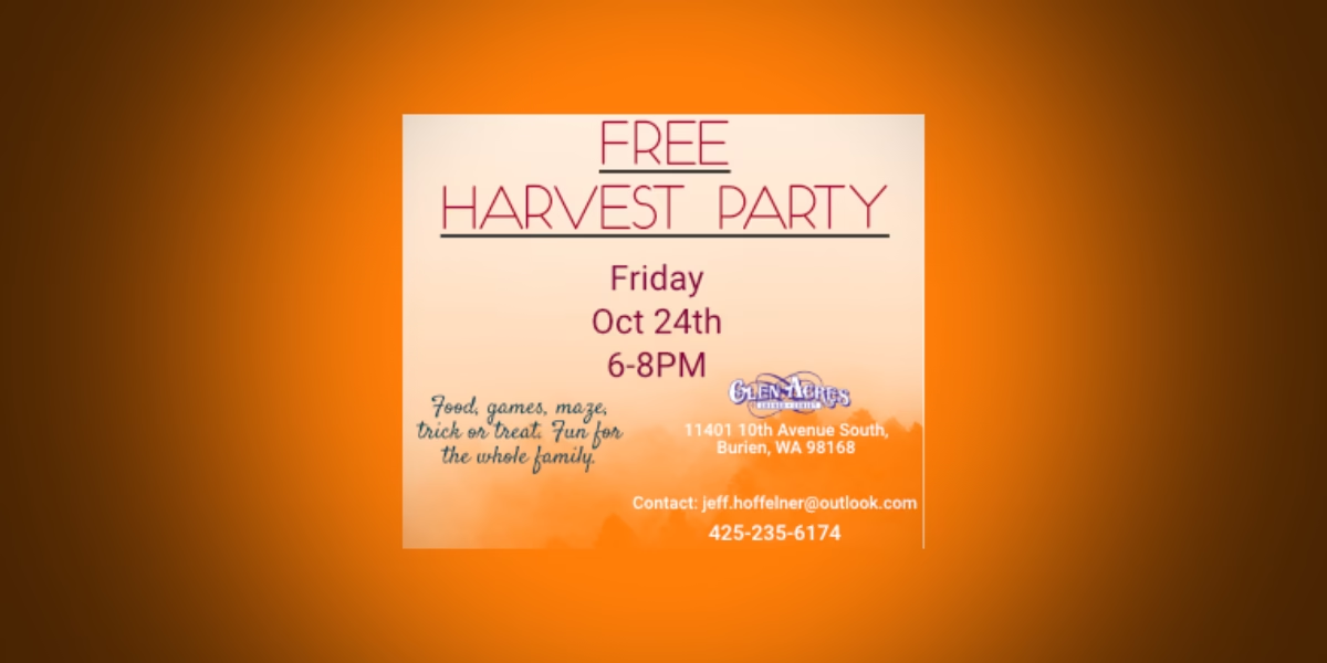
The National Weather Service issued a “Wind Advisory” early Wednesday morning, so again, be sure to double-tie down your blue (and other colored) tarps Burien, as sustained winds of 20-30mph may be coming.
Here’s the advisory in all its weatherspeak glory:
… Wind Advisory in effect from 1 PM this afternoon to 1 am PST Thursday…
The National Weather Service in Seattle has issued a Wind Advisory… which is in effect from 1 PM this afternoon to 1 am PST Thursday.
Southerly winds will increase today… peaking late this afternoon through the evening hours. Sustained winds of 20 to 30 mph are expected with gusts to 40 to 50 mph… mainly this evening. The strongest winds are expected to occur over the north Hood Canal across to western Snohomish County… the entrances to the Strait and over the lower Chehalis valley.
Precautionary/preparedness actions…
A Wind Advisory is issued when sustained winds of 30 to 39 mph or gusts of 45 to 57 mph are likely. Winds this strong can snap small tree branches… topple small or shallow-rooted trees… and cause local power outages.
You know it’s November in the Northwest when another Weather Advisory gets posted – this one a “Wind Advisory” predicted to hit around 6pm Sunday night and continue for at least another 24 hours.
As usual, batten down your blue tarps Burien!
Here’s the statement, issued by the National Weather Service at 3:22pm Sunday, Nov. 15th:
Statement as of 3:22 PM PST on November 15, 2009
… Wind Advisory in effect from 6 PM this evening to 6 PM PST Monday…
… High wind watch in effect from Monday evening through Tuesday afternoon…
The National Weather Service in Seattle has issued a Wind Advisory… which is in effect from 6 PM this evening to 6 PM PST Monday. A high wind watch has also been issued. This high wind watch is in effect from Monday evening through Tuesday afternoon.
South winds of 25 to 35 mph with local gusts to 50 mph are expected to develop tonight and continue through much of the day Tuesday.
A deeper low is expected to move north through the coastal waters late Monday night and Tuesday. Widespread damaging winds of 40 mph with gusts to 60 mph are possible with this second deeper system.
Precautionary/preparedness actions…
A Wind Advisory is issued when sustained winds of 30 to 39 mph or gusts of 45 to 57 mph are likely. Winds this strong can snap small tree branches… topple small or shallow-rooted trees… and cause local power outages.
A high wind watch means conditions are favorable for damaging winds. High winds can topple trees… down power lines… and damage some structures. People in the watch area should prepare for the possibility of power outages.
Ala one of our favorite blogs – Boingboing.net – this posting is intended to serve as a “chaser” to the previous, horrific child abuse story.
Here is original artwork from our new artist Danielle Burton, a nice fall scene of downtown Burien that may help clear your mental palate if you stare at it long enough:
Fall has definitely fallen unto our area, and to celebrate the refreshing, crisp air and colorful leaves, we present to you a very zen-like Photo/Audio Slideshow created at Seahurst Park by Photographer Michael Brunk:

Click to Play Michael Brunk’s Zen-like Autumn SoundSlideshow
According to our friends at Burien Parks:
“Due to seasonal changes, Burien’s two gated parks (Seahurst & Eagle Landing) are now closing earlier.
Gates now closed at 7pm.”
So, now you know to get yourself outta there before you’re trapped like you’re in a b-rate, B-Town horror movie…
At precisely 2:18pm PDT today (Tuesday, Sept. 22nd), the autumnal equinox takes place, shifting us into the wonderful Fall season chock full of colorful, crunchy leaves, football, and our favorite, walking through freshly-woven spider webs every flippin’ morning.
However, oddly enough, today’s weather will be anything but fall-like, with a high predicted to be in the mid-80s (perhaps this is Summer’s last hurrah?). According to Meteorologist Cliff Mass:
A huge, high-amplitude upper ridge is developing over the west coast … This is really amazing…with unusually high pressure developing aloft and at low levels. Such a major ridge is associated with warm temps aloft and with offshore flow and added warming at low levels … Very, very warm temps in California, offshore and downslope flow over the Cascades, warming over our region.
Western Washington should surge into the mid-70s tomorrow and mid-80s on Wednesday and Thursday. Impressive for late September!
Back to Fall – according to people much smarter than us, the September equinox is defined as:
“When the sun crosses the celestial equator and moves southward, out of the northern hemisphere. The location on the earth where the sun is directly overhead at solar noon is known as the ’subsolar point.’ The point is located on the equator during both the September (fall) and March (spring) equinox. At those days, the earth’s axis of rotation is perpendicular to the line connecting the centers of the earth and the sun. “
Some say that you can stand an egg on its end “only on an equinox” (Sept. or March), but, according to Snopes, that isn’t necessarily true:
“”Rarely does a year go by in which a local TV station doesn’t send a reporter out to a neighborhood park to capture images of people decidedly placing eggs on the ground and watching in amazement as the eggs stand on end. Rarely do we see any new stories reporting that this same feat can be achieved every other day of the year as well.
“The Chinese are thought to have originated the practice of standing eggs on end during the equinox. Just as the equinox symbolically restores balance to the world by signalling its rebirth after a season of darkness, the equinox literally balances the day by dividing it into equal portions of darkness and light. If the symbol of fertility — eggs — could be balanced on end during a day equally divided between day and night, this was a sign that all nature was in harmony. That the balancing of eggs could be achieved on any day of the year was of no importance; what everyone wanted and needed was a familiar, reassuring ritual to demonstrate that all was right with the world.”
However, we still invite all Readers to try and balance an egg on its end today, take some pics and email ‘em in – we’ll print the most interesting and make you famous, at least in Burien.
Here’s a tip on how to successfully get eggs to balance:
- Because most eggs’ yolks are off center, try shaking the egg – this will break up the yolk and lower the egg’s center of gravity to help it balance.
- And because egg shells have tiny bumps on them, they can act as “feet” to stand the egg up.
- Have one person stand the egg up while the other takes the pic.
- Stop bumpin’ the table dude, I’m trying to make the egg stand on its end!
Found this nicely-moistened and unusually-placed spider web on the rear view mirror of the B-Town Blogmobile the other morning and took this pic:

(don’t worry, the spider who made this masterpiece survived the short commute and shortly re-built his/her mini mansion…)
Fall officially begins at 8:44am PDT today (Monday, Sept. 22), and what better way to celebrate the season of spiders, colorful leaves and pumpkin slingshots than by taking a look back at summer through this exclusive B-Town Blog slideshow:

The patented, trademarked and copyrighted B-Town Blog Weather Rock®™© looks like its on the verge of needing a very absorbent diaper soon, as it’s just issued the following Weather Advisory:
… A powerful and wet Pacific storm will bring significant rainfall to western Washington tonight through Wednesday…
A powerful storm more typical of autumn will bring rain… locally heavy… to the area tonight through Wednesday. Storm total rainfall amounts are expected to be in the 2 to 4 inch range in the Olympics… and the 1 to 3 inch range on the coast and Cascades. Elsewhere… amounts will be less or generally in the quarter to one inch range. It is possible that the heavy rains could lead to water rises on small creeks as well as ponding of water in low lying areas.
In addition to the significant rainfall… this storm system will bring gusty winds and usher in a colder air mass Wednesday night. By early Thursday… the snow levels are expected to be mainly in the 6000 to 6500 foot range. People planning on hiking or camping in the mountains should be prepared for Fall-like weather and plan accordingly.
If you don’t have your own patented, trademarked and copyrighted Weather Rock®™©, you can get the full weather report here.


