UPDATE 2:45pm 11/16/09: It appears that Seattle City Light lineworkers restored power about 2pm Monday (Nov. 16th) to most of the 4,000 homes and businesses affected by an outage in Burien and unincorporated King County.
According to Seattle City Light’s website, the outage started about 12:40pm as the result of an equipment failure that started a utility pole fire on SW 104th Street.
The repair crew expected to restore service for the remaining 360 customers without power by 5pm.
The general boundaries of the remaining outage were SW 100th Street on the north, SW 108th Street on the south, Occidental Way SW on the east, and 10th Avenue SW on the west.
PREVIOUSLY: According to the latest “Tweet” from Seattle City Light:
Power restored to most customers in Burien, King County outage.
Remaining 360 customers should have power back by 5 p.m
A previous Tweet from SCL said:
Burien, King County outage caused by pole fire. Crews on site making repairs. Estimate to restore power by 4 p.m.
EVEN MORE PREVIOUSLY: On Monday afternoon (Nov. 16th) around 12:40pm, 
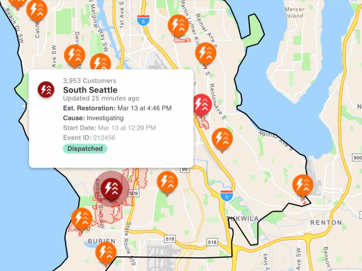
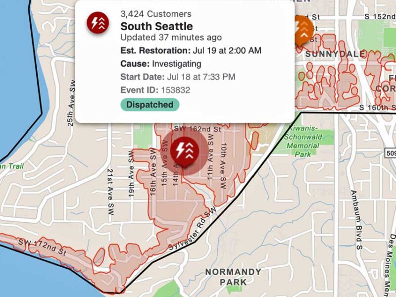
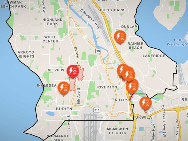
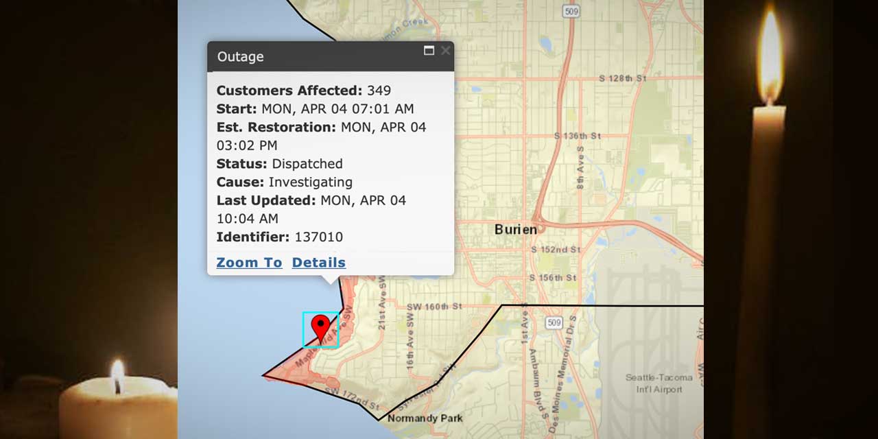
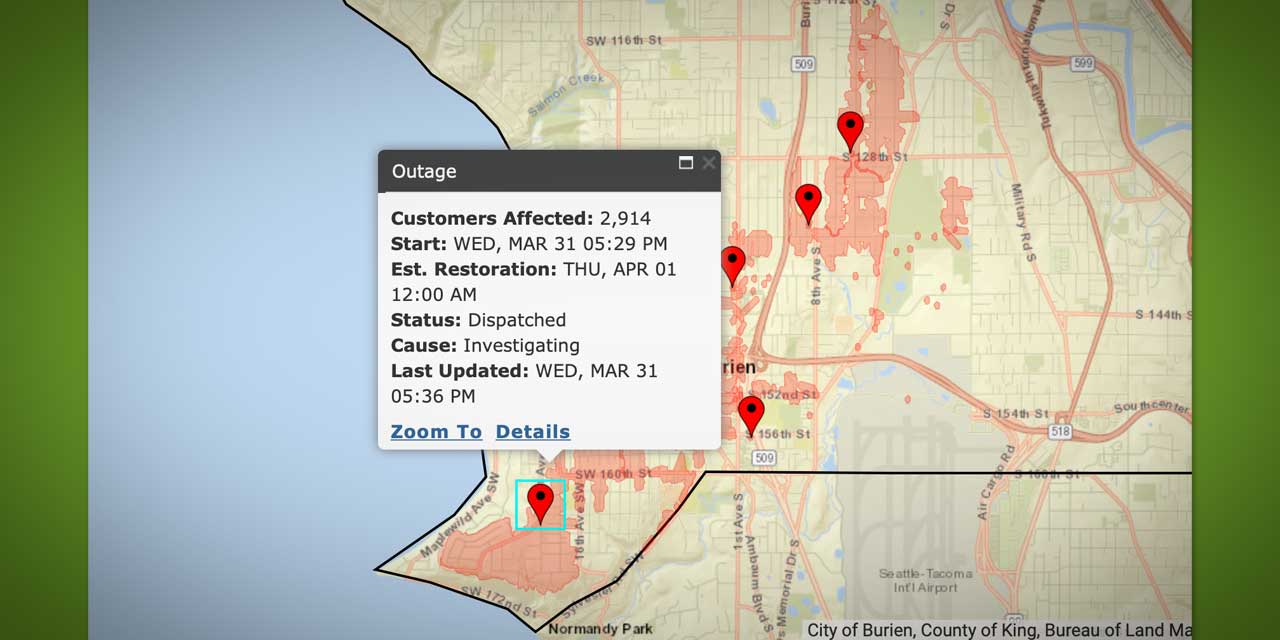
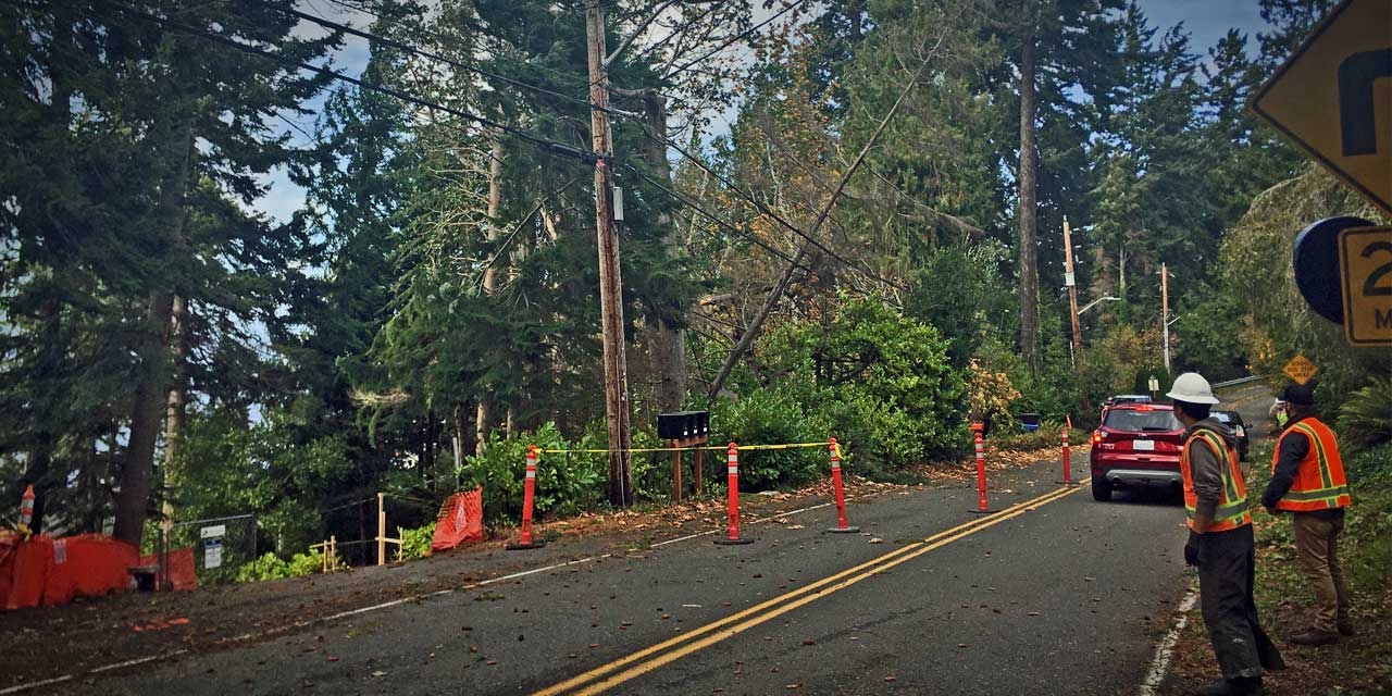
Seattle City Light reported that around 4,000 customers have lost power in the Burien and North Highline areas.
According to their website:
A repair crew was immediately dispatched to identify the problem and make repairs. An estimate for when power might be restored was not immediately available.
The general boundaries of the outage were SW 95th Street on the north, SW 131st Street on the south, Glendale Way S on the east, and Seola Beach Drive SW on the west.
A proposed 8.8 percent rate increase by Seattle City Light, which would begin in January, “will affect most of our residents,” Burien City Manager Mike Martin said last week.
City Light provides electrical service to almost all of Burien and all of the North Highline area. The Seattle City Council will vote on whether to accept or amend the rate increase request later this month.
Included in City Light’s rate analysis supporting the proposed increase are additional increases of 5.4 percent in 2011 and 6.6 percent in 2012.
Because City Light is a publicly owned utility, it is not regulated by the Washington Utilities and Transportation Commission. Oversight comes instead from the Seattle City Council.
Martin said Burien has asked City Light for clarification about the need for a rate hike at this time, “since it will affect so many of our residents,” but has not yet received a reply.
Outgoing Seattle Mayor Greg Nickels called for the increase when he submitted in September his proposed 2010 budget.
In a report to the Burien City Council, Martin noted that reasons given for a higher power rate when Nickels announced his budget proposal were the poor economy, a sharp decline in sales of surplus power and a larger-than-proposed rate decrease in 2007.
Surplus power sales have been driven down by low natural-gas prices, according to Seattle budget director Dwight Dively. While Seattle’s 2009 budget anticipated surplus power sales of $140 million, only about half that amount has been sold – leaving City Light with a $70 million shortfall.
Martin added that City Light also says the increase is needed to maintain its net operating income reserve, although “there is no legal reserve requirement” for that reserve as structured by the utility.
Citing City Light’s reference to cash flow, Martin replied, “The economy is also hurting our residents’ cash flow.”
In a statement to The B-Town Blog, he said, “At this time, it’s still not entirely clear what’s going on.” Burien staff will seek more information from City Light within the next couple of weeks.

Notes from Monday night’s Burien City Council meeting (Feb. 9th):
LAKE-TO-SOUND TRAIL
King County Council Chair Julia Patterson and her team presented the 17-mile Lake-To-Sound Trail that would begin in Renton, end at Puget Sound in Des Moines and wind its way through Tukwila, Burien and SeaTac. The proposed trail would connect the Cedar River Trail, Green River Trail, Westside Trail and the Des Moines Creek Trail, making its way along the light rail station in Tukwila and then over to Burien and possibly along Des Moines Memorial Drive.
Voters have already approved a levy that would contribute $705,000 over the next year as well as $3.75 million over the next five years, pledged from the King County Parks expansion levy in 2007. Deputy Mayor Rose Clark said:
“I can’t tell you how long I have wanted a trail in Burien like this one.”
Council Chair Patterson has already made visits to Washington DC asking for measures to be included in upcoming stimulus budgets for the Lake-To-Sound Trail. According to Patterson, DC is listening to any proposals that would open up jobs for local residents and this project would do just that.
Here’s a map of the proposed trail, which starts in Renton and ends in Des Moines:

DISCOVER BURIEN
Executive Director of Discover Burien Patty Sader presented promotional efforts put forth from the Discover Burien team building community awareness for local businesses. Large banners reminding the community to shop local, a restaurant guide brochure, newsletters and welcome wagon bags given to each new business that opens in the Burien community.
Coming up with ideas business and residents alike can do to overcome tough economic times, Sader brought to light the average of 10-12 business that applied for licenses despite the odds. With 147 new business owners in Burien a light of hope and perseverance shines in what could be seen as a dark financial time.
CITY LIGHT PLANNED POWER OUTAGE
The City Council addressed the City Light project that had proposed to shut power off to many businesses along 152nd Monday February 9th for 8 hours in the middle of the day. With a vehement protest from the business along this main stretch of Burien, City Light agreed to move the scheduled power outage to late Thursday February 12th overnight. Power is scheduled to be restored after the electricity to the new city library and city hall building has been installed approximately 6 am.
ANNEXATION UPDATE
On Monday the Seattle City Council voted 8 to 1 against Burien’s memo proposed to split and adopt the North Highline neighborhoods.
Council Member Gordon Shaw said:
“The current proposal will save money in the long run.”
“I think it’s an ideal situation for Burien to finally be in an adversarial position. It’s good for Burien to not have opposition.”
“Woo! Snow happens even in Burien” by Flickr Photog Crocidillicus
The big storm’s a-comin’ folks, and should hit sometime tonight and continue through Sunday morning.
Most likely there will be significant snowfall in the Burien area (4-8 more inches), since we lie in the zone where the storm will hang out. Also be prepared, as there will be high winds and possibly sleet, which means ice on power lines, tree branches, etc. and you know what that means – power outages.
Here’s the Weather Advisory as of Saturday 12/20/08 at 5:18am:
The Winter Storm Warning is now in effect from 4 PM this afternoon to 10 am PST Sunday.
A major winter storm is on tap for later today into Sunday. Heavy snow is expected to develop along the coast this afternoon and then spread into the interior of western Washington early this evening. Heaviest snow will occur on the Kitsap peninsula… along Hood Canal… and from Olympia and Chehalis west to the central coast near Ocean Shores. 10 to 18 inches of snow is expected close to the Hood Canal. Other locations within this area should get 5 to 12 inches of snow.
Along the I-5 Corridor North of Tacoma… including Seattle and Everett… storm total snowfall of 4 to 8 inches is expected. In general… lighter amounts will occur near the Cascade foothills with heavier amounts farther west along the shores of Puget Sound. Some parts of eastern King County… where wind is a big threat… will receive 1 inch or less of snowfall. The heaviest snowfall is expected between 7 PM tonight and 4 am Sunday morning.
Late tonight into Sunday morning… locations from Tacoma on south through Lewis County and west to the coast the precipitation could possibly change over to sleet or freezing rain. Freezing rain is most likely in Grays Harbor County and the lower Chehalis valley. If more precipitation occurs in the form of freezing rain than snow… then an ice storm would be possible with ice accumulations in excess of one quarter of an inch. This is not a certainty but should be kept in mind. Ice storms are capable of causing power lines and large tree branches to snap and cause major travel disruptions.
Precautionary/preparedness actions…
A Winter Storm Warning means significant amounts of snow… sleet… and ice are expected or occurring. Strong winds are also possible. This will make travel very hazardous or impossible.
Have any cool snow/ice photos to share?
Please either email us or add ‘em to our Flickr Group so we can share them!
As of 8:30pm Friday night (Dec. 12th), Seattle City Light crews have restored power to Burien, the last large outage from today’s storm that once affected 4,000 customers.
During the afternoon, more than 8,000 customers lost power in City Light’s service area.
The range of the outage started on the north at South Director Street to SW 150th Street on the south; and on the east from 12th Ave. South to the west at 25th Ave SW.
Seattle City Light says they’re prepared for any further outages due to wind or cold, and they also offer up this warning:
In the event of a large-scale outage, residents should be ready to fend for themselves for at least three days.
One of the best steps is to assemble an emergency kit with at least three days of food and water for each person in the family and any family pets. Other items to include are a hand-crank or battery-operated flashlight and radio, fresh batteries, a survival blanket, a first aid kit, pocket tissues and hand sanitizer wipes. For a complete list of what to include, please visit http://www.govlink.org/3days3ways/.
City Light also reminds people that barbecue grills and emergency generators should never be operated indoors. Doing so could cause fatal carbon monoxide poisoning. If you lose power, dress in layers to stay warm and seal up drafty windows and doors to slow the loss of heat in your home.
Our advice:
- Stock up Saturday on groceries (for the entire week – see weather warning below) before it gets too cold and the roads become difficult
- Go to McLendon’s and get some wrap to use on your water pipes and do some serious winterizing around the house
- Make sure your car has anti-freeze
- Get ready for no school on several days this coming week (perhaps)
- Be prepared to stay home if indeed the snow and ice arrive
The Weather Service is predicting up to a week or longer of a major cold snap starting Saturday, and they’re calling it “the coldest since 1990″:
An Arctic cold front will move south through western Washington on Saturday…pulling in much colder air in its wake. The front will first arrive over the north interior early in the morning…where Fraser outflow winds will pick up on Saturday morning… bringing in very cold and very windy conditions. As the front slips further south during the day with unsettled conditions continuing…snow accumulations of 1 to 3 inches are possible for much of The Lowlands on Saturday afternoon and evening. With the passage of the cold front… daytime temperatures will actually fall. As temperatures fall below freezing… wet surfaces could quickly become icy… so be sure to watch your footing and avoid slip-and-fall accidents.
By Monday… temperatures will generally reach daytime highs only in the 20s with nighttime lows in the teens or lower. With the continuation of strong northeast winds over the north interior… wind chill values should drop to 10 or 15 below zero. Wind chills this low can cause frostbite to exposed skin in about 30 minutes. The north interior will be under the gun for brutally cold wind chills for much of the week ahead as cold air continues to funnel out of the Fraser valley.
Cold sub-freezing weather should continue over nearly all of western Washington through next week. In addition… a weather system on Wednesday could interact with the stubborn cold air mass to produce a renewed threat of accumulating snow nearly everywhere except perhaps the immediate coastline.
The bottom line is that western Washington should experience the coldest weather in a couple of decades during the week ahead. Please be prepared for an unusually prolonged and intense period of winter weather.


